Painting with three prominent indigenous warriors in single file facing left, wearing cloaks and grasping staves, followed by a dog. Below them and to the right is the smaller image of a mounted Spaniard with a raised lance. To the left and indigenous porter carries a pack fixed by a strap across his forehead, and sports a staff in one hand. All are apparently moving towards a doorway at top left.
← ホームへ戻る

グアテマラ征服の歴史スペイン帝国によるマヤ文明への侵攻

🗓 2026年8月10日

16世紀、スペイン帝国はアステカ帝国を崩壊させた勢いのまま、中米の地へと進出しました。その中心となったのが、現在のグアテマラ地域における征服活動です。この過程は単なる軍事的な衝突にとどまらず、高度な文明を築いていたマヤの人々と、欧州からもたらされた未知の病原体、そして複雑な政治的同盟が絡み合った激動の時代でした。

スペイン側の作戦は、少数の精鋭兵と、彼らに協力した先住民の補助兵を組み合わせた戦略的なものでした。彼らは地形の険しさと先住民の激しい抵抗に直面しながらも、徐々にその支配圏を広げていきました。
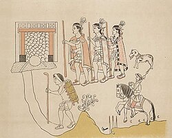
Painting with three prominent indigenous warriors in single file facing left, wearing cloaks and grasping staves, followed by a dog. Below them and to the right is the smaller image of a mounted Spaniard with a raised lance. To the left and indigenous porter carries a pack fixed by a strap across his forehead, and sports a staff in one hand. All are apparently moving towards a doorway at top left.

Key Facts

  • 主要指導者: スペイン側はペドロ・デ・アルバラードが中心となり、エルナンド・コルテスやゴンサロ・デ・アルバラード・イ・コントレラスらが関与しました。
  • 壊滅的な被害: 1525年から1550年の間に、天然痘や麻疹などの旧世界由来の感染症により、推定160万人が死亡しました。
  • 地理的展開: 高地(ハイランド)の王国から、北部のペテン低地、太平洋沿岸の低地へと段階的に征服が進みました。
  • 最終的な結果: 激しい抵抗があったものの、最終的にスペイン帝国が勝利し、植民地支配を確立しました。

征服の舞台:グアテマラの地理と勢力図

当時のグアテマラは、地理的に大きく3つのエリアに分かれていました。南部の太平洋低地、中央の険しい高地、そして北部のペテン低地です。これらの地域には異なる言語や文化を持つマヤの諸王国が点在しており、スペイン人はこの分断された状況を利用して攻略を進めました。
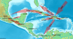
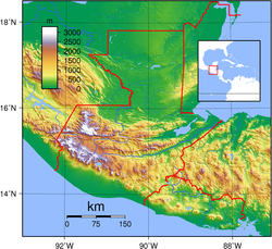
Spanish expansion routes in the Caribbean during the early 16th century
Guatemala is situated between the Pacific Ocean to the south and the Caribbean Sea to the northeast. The broad band of the Sierra Madre mountains sweeps down from Mexico in the west, across southern and central Guatemala and into El Salvador and Honduras to the east. The north is dominated by a broad lowland plain that extends eastwards into Belize and north into Mexico. A narrower plain separates the Sierra Madre from the Pacific Ocean to the south.

特に高地地域では、キチェ王国などの強力な勢力が支配しており、彼らは独自の軍事戦術と武器を用いて侵略者に立ち向かいました。しかし、スペイン側は鉄製の武器、馬、そして火器という圧倒的な技術的優位を持っていました。
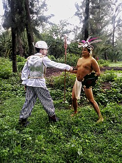
Representation of a battle between a native and a conquistador.
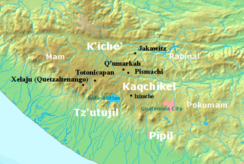
The highlands of Guatemala are bordered by the Pacific plain to the south, with the coast running to the southwest. The Kaqchikel kingdom was centred on Iximche, located roughly halfway between Lake Atitlán to the west and modern Guatemala City to the east. The Tzʼutujil kingdom was based around the south shore of the lake, extending into the Pacific lowlands. The Pipil were situated further east along the Pacific plain and the Pocomam occupied the highlands to the east of modern Guatemala City. The Kʼicheʼ kingdom extended to the north and west of the lake with principal settlements at Xelaju, Totonicapan, Qʼumarkaj, Pismachiʼ and Jakawitz. The Mam kingdom covered the western highlands bordering modern Mexico.

高地王国の陥落と激しい抵抗

スペイン軍の最初の大きな目標となったのが、キチェ王国の首都クマルカフでした。激しい戦闘の末、この都市はスペイン軍によって焼き払われ、キチェの支配体制は崩壊しました。その後、スペイン人はカクチケル族と一時的な同盟を結び、共通の敵であるツトゥヒル王国などを攻略しました。
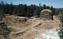
Grass- and scrub-covered ruins set against a backdrop of low pine forest. A crumbling squat square tower stands behind to the right, all that remains of the Temple of Tohil, with the remains of the walls of the ballcourt to the left in the foreground.
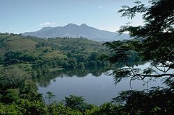
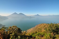
View across hills to a broad lake bathed in a light mist. The mountainous lake shore curves from the left foreground backwards and to the right, with several volcanoes rising from the far shore, framed by a clear blue sky above.

しかし、同盟関係は不安定であり、後にカクチケル族も反旗を翻します。スペイン軍は数ヶ月に及ぶ包囲戦の末にザクレスを陥落させるなど、執拗な軍事行動を続けました。また、クチュマタネスのような遠隔地や険しい地形の地域では、征服に多大な時間を要しました。
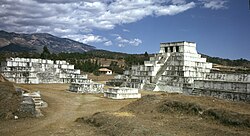
A cluster of squat white step pyramids, the tallest of them topped by a shrine with three doorways. In the background is a low mountain ridge.
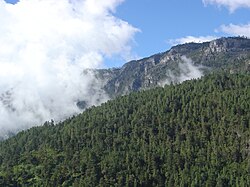
View over a heavily forested mountain slope towards rugged peaks beyond, separated from them by a mass of low cloud.

低地への拡大とペテンの攻略

高地の制圧後、スペインの関心は低地へと移りました。太平洋沿岸ではシンカ族との激しい衝突が繰り返され、北部の低地ではイサバル湖周辺にサン・フェリペ城などの要塞を築き、防衛と支配を固めました。
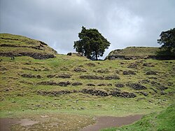
A series of semi-collapsed dry-stone terraces, overgrown with short grass. On top of the uppermost of five terraces stand the crumbling, overgrown remains of two large buildings flanking the ruins of a smaller structure. A tree grows from the right hand side of the smaller central building, and another stands in at extreme right, on the upper terrace and in front of the building also standing on it. The foreground is a flat plaza area, with the collapsed flank of a grass-covered pyramid at bottom right. The sky is overcast with low rainclouds.
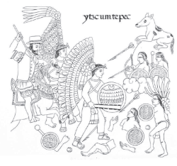
Page from the Lienzo de Tlaxcala depicting the conquest of Izcuintepeque
The Pacific slope of Jutiapa was the scene of a number of battles with the Xinca.

特筆すべきは、アステカ征服者エルナンド・コルテスの遠征です。彼は1525年、反乱を起こしたクリストバル・デ・オリドを鎮圧するため、メキシコから陸路でペテン地域を横断しました。この遠征には、スペイン兵だけでなく、数千人のメキシコ人戦士やチョンタル・マヤの運搬人が同行していました。
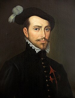
Painting of Hernán Cortés
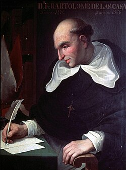
Painting of Bartolomé de las Casas
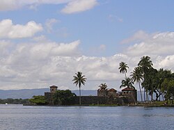
The Castillo de San Felipe was a Spanish fort that guarded the entrance to Lake Izabal.

北部の低地は、その密林と隔絶された環境から、スペインによる完全な支配が最も遅れた地域となりました。最終的にノフペテンが陥落することで、この地域の征服は完結へと向かいました。
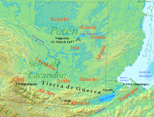
Northern Guatemala is a flat lowland plain dropping off from the Cuchumatanes mountain range sweeping across in an arc to the south. To the east of the mountains is the large lowland Lake Izabal, with an outlet into the Amatique Bay to the east, which itself opens onto the Gulf of Honduras. Immediately north of the mountains is the Lacandon forest, with Petén to the northeast. Ystapalapán was a settlement in the western Cuchumatanes, in the territory of the Chuj. Cobán was in Qʼeqchiʼ territory, in the foothills halfway between Ystapalapán in the west and Lake Izabal in the east. Xocolo was at the northeastern extreme of Lake Izabal, where it flows out towards the sea. Nito, also known as Amatique, was on the coast where the river flowing out of the lake opened into the Amatique Bay. The area south of the lake was Toquegua territory. The Manche occupied the lands to the northwest of the lake, with the Acala to their west between the Manche and the Chuj. The Lacandon were northwest of the Acala, straddling the border with Mexico. Lake Petén Itzá was in the centre of Petén, to the north. It was the location of Nojpetén, with the Itza lands stretching southwards from the lake. To the east of the Itza and northeast of the Manche were the Mopan, on the border with Belize. North of the Mopan were the Yalain, east of Lake Petén Itzá. The Kowoj were to the northeast of the lake and the Kejache to the northwest. The "Tierra de Guerra" ("Land of War") covers a broad northern swathe of the mountains and the southern portion of the lowlands.

征服の概要まとめ

グアテマラ征服の主要データ
項目 詳細内容
主要期間 16世紀前半(1524年〜)から17世紀末まで
スペイン側指揮官 ペドロ・デ・アルバラード、エルナンド・コルテス
先住民側指導者 テクン・ウマン、ベレヘ・カト等
最大の死因 天然痘、麻疹などの旧世界由来の感染症
結果 スペイン帝国の勝利と植民地化

Frequently Asked Questions

スペイン軍が少人数で征服できた理由は?

鉄製の武器や馬、火器といった軍事技術の圧倒的な差に加え、先住民同士の対立を利用して同盟を組み、内部から崩壊させたことが大きな要因です。

感染症はどのような影響を与えましたか?

天然痘や麻疹などの病原体に対し、先住民は免疫を持っていませんでした。これにより、戦闘以前に人口の大部分が失われ、社会構造が崩壊したため、スペイン側の支配が容易になりました。

ペテン地域の征服が遅れたのはなぜですか?

ペテン地域は深い密林に囲まれ、地理的に非常に隔絶されていたため、スペイン軍にとってアクセスが困難であり、抵抗勢力が長く生き残ることができました。

バルトロメ・デ・ラス・カサスとはどのような人物ですか?

ドミニコ会修道士であり、スペインによる先住民への残酷な扱いを批判し、武力ではなく平和的な手段によるキリスト教への改宗を提唱した人物です。

References

  1. While most sources accept the modern town of Flores on Lake Petén Itzá as the location of Nojpetén/Tayasal, Arlen Chase argued that this identification is incorrect and that descriptions of Nojpetén correspond better to the archaeological site of on . Chase 1976. See also the detailed rebuttal by Jones, Rice and Rice 1981.
  2. In the original this reads: ...por servir a Dios y a Su Majestad, e dar luz a los questaban en tinieblas, y también por haber riquezas, que todos los hombres comúnmente venimos a buscar. "(...those who died) to serve God and His Majesty, and to bring light to those who were in darkness, and also because there were riches, that all of us came in search of." Díaz del Castillo 1632, 2004, p. 720. Chapter CCX: De otras cosas y proyectos que se han seguido de nuestras ilustres conquistas y trabajos "Of other things and projects that have come about from our illustrious conquests and labours".
  3. Recinos places all these dates two days earlier (e.g. the Spanish arrival at Iximche on 12 April rather than 14 April) based on vague dating in Spanish primary records. Schele and Fahsen calculated all dates on the more securely dated Kaqchikel annals, where equivalent dates are often given in both the Kaqchikel and Spanish calendars. The Schele and Fahsen dates are used in this section. Schele & Mathews 1999, p. 386. n. 15.
  4. A peso was a Spanish coin. One peso was worth eight reales (the source of the term "pieces of eight") or two tostones. During the conquest, a peso contained 4.6 grams (0.16 oz) of gold. Lovell 2005, p. 223. Recinos 1952, 1986, p. 52. n. 25.
  5. Recinos 1998, p. 19. gives sixty deserters.
  6. The location of the historical city of Mixco Viejo has been the source of some confusion. The archaeological site now known as Mixco Viejo has been proven to be Jilotepeque Viejo, the capital of the Chajoma. The Mixco Viejo of colonial records has now been associated with the archaeological site of Chinautla Viejo, much closer to modern Mixco. Carmack 2001a, pp. 151, 158.
  7. The rebellion and the Spanish response, led by Pedro de Portocarrero, is described in Part One Book 13 Chapter IV of the Recordación Florida.
  8. Most of these were native allies.
  9. The colony of Guatemala at this time consisted only of the highlands and Pacific plain. Lovell et al. 1984, p. 460.
  10. His baptismal name.

📸 フォトギャラリー

Painting with three prominent indigenous warriors in single file facing left, wearing cloaks and grasping staves, followed by a dog. Below them and to the right is the smaller image of a mounted Spaniard with a raised lance. To the left and indigenous porter carries a pack fixed by a strap across his forehead, and sports a staff in one hand. All are apparently moving towards a doorway at top left.
Spanish expansion routes in the Caribbean during the early 16th century
Guatemala is situated between the Pacific Ocean to the south and the Caribbean Sea to the northeast. The broad band of the Sierra Madre mountains sweeps down from Mexico in the west, across southern and central Guatemala and into El Salvador and Honduras to the east. The north is dominated by a broad lowland plain that extends eastwards into Belize and north into Mexico. A narrower plain separates the Sierra Madre from the Pacific Ocean to the south.
Representation of a battle between a native and a conquistador.
The highlands of Guatemala are bordered by the Pacific plain to the south, with the coast running to the southwest. The Kaqchikel kingdom was centred on Iximche, located roughly halfway between Lake Atitlán to the west and modern Guatemala City to the east. The Tzʼutujil kingdom was based around the south shore of the lake, extending into the Pacific lowlands. The Pipil were situated further east along the Pacific plain and the Pocomam occupied the highlands to the east of modern Guatemala City. The Kʼicheʼ kingdom extended to the north and west of the lake with principal settlements at Xelaju, Totonicapan, Qʼumarkaj, Pismachiʼ and Jakawitz. The Mam kingdom covered the western highlands bordering modern Mexico.
Grass- and scrub-covered ruins set against a backdrop of low pine forest. A crumbling squat square tower stands behind to the right, all that remains of the Temple of Tohil, with the remains of the walls of the ballcourt to the left in the foreground.
View across hills to a broad lake bathed in a light mist. The mountainous lake shore curves from the left foreground backwards and to the right, with several volcanoes rising from the far shore, framed by a clear blue sky above.
A cluster of squat white step pyramids, the tallest of them topped by a shrine with three doorways. In the background is a low mountain ridge.
View over a heavily forested mountain slope towards rugged peaks beyond, separated from them by a mass of low cloud.
A series of semi-collapsed dry-stone terraces, overgrown with short grass. On top of the uppermost of five terraces stand the crumbling, overgrown remains of two large buildings flanking the ruins of a smaller structure. A tree grows from the right hand side of the smaller central building, and another stands in at extreme right, on the upper terrace and in front of the building also standing on it. The foreground is a flat plaza area, with the collapsed flank of a grass-covered pyramid at bottom right. The sky is overcast with low rainclouds.
Page from the Lienzo de Tlaxcala depicting the conquest of Izcuintepeque
The Pacific slope of Jutiapa was the scene of a number of battles with the Xinca.
Painting of Hernán Cortés
Painting of Bartolomé de las Casas
The Castillo de San Felipe was a Spanish fort that guarded the entrance to Lake Izabal.
Northern Guatemala is a flat lowland plain dropping off from the Cuchumatanes mountain range sweeping across in an arc to the south. To the east of the mountains is the large lowland Lake Izabal, with an outlet into the Amatique Bay to the east, which itself opens onto the Gulf of Honduras. Immediately north of the mountains is the Lacandon forest, with Petén to the northeast. Ystapalapán was a settlement in the western Cuchumatanes, in the territory of the Chuj. Cobán was in Qʼeqchiʼ territory, in the foothills halfway between Ystapalapán in the west and Lake Izabal in the east. Xocolo was at the northeastern extreme of Lake Izabal, where it flows out towards the sea. Nito, also known as Amatique, was on the coast where the river flowing out of the lake opened into the Amatique Bay. The area south of the lake was Toquegua territory. The Manche occupied the lands to the northwest of the lake, with the Acala to their west between the Manche and the Chuj. The Lacandon were northwest of the Acala, straddling the border with Mexico. Lake Petén Itzá was in the centre of Petén, to the north. It was the location of Nojpetén, with the Itza lands stretching southwards from the lake. To the east of the Itza and northeast of the Manche were the Mopan, on the border with Belize. North of the Mopan were the Yalain, east of Lake Petén Itzá. The Kowoj were to the northeast of the lake and the Kejache to the northwest. The "Tierra de Guerra" ("Land of War") covers a broad northern swathe of the mountains and the southern portion of the lowlands.