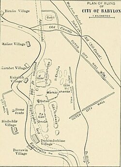
A map of Babylon, with major areas and modern-day villages
← ホームへ戻る
バビロンメソポタミアイラクハンムラビネブカドネザル2世

バビロンの歴史と遺構メソポタミアを象徴する古代都市の栄枯盛衰

🗓 2026年8月11日

現代のイラク、ヒッラ近郊に位置するバビロンは、かつてメソポタミア南部のユーフラテス川流域で、政治・文化の頂点に君臨した伝説的な都市です。アッカド語を話すバビロニア地域の中心地として、古代世界で最も重要な都市の一つとなり、その名は後世の文学や宗教においても象徴的な意味を持ち続けています。

バビロンは、紀元前18世紀の古バビロニア帝国と、紀元前7世紀から6世紀にかけての新バビロニア帝国という、二つの巨大な帝国の首都として繁栄しました。また、アケメネス朝ペルシアなどの他帝国の地方首都としても機能し、ヘレニズム時代に衰退するまで、近東における都市文明の先駆的な役割を果たしました。
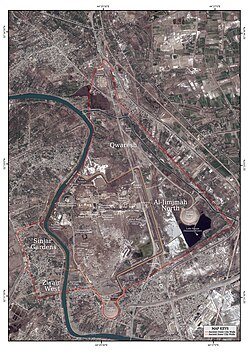
A map of Babylon, with major areas and modern-day villages

主要な事実(Key Facts)

  • 所在地: イラク共和国バビル県ヒッラ(バグダッドの南約85km)
  • 最盛期の人口: 推定20万人以上(紀元前1770-1670年頃および紀元前612-320年頃)
  • 主要な統治者: ハンムラビ王(古バビロニア)、ネブカドネザル2世(新バビロニア)
  • 世界遺産: 2019年にユネスコ世界文化遺産に登録
  • 都市規模: 全体で約1,000ヘクタール、城壁内部は約450ヘクタール

都市の変遷と歴史的展開

黎明期から古バビロニア時代へ

バビロンの起源については諸説あり、古典的な記録では紀元前23世紀頃の創建が伝えられています。当初は小さな独立した都市国家でしたが、紀元前18世紀にアモリ人の王ハンムラビが古バビロニア帝国を築いたことで、地域最大の都市へと急成長しました。これにより、バビロンは聖都ニップルを凌ぐ宗教的・政治的中心地となり、南メソポタミア全域が「バビロニア」と呼ばれるようになりました。
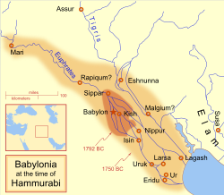
A map showing the Babylonian territory upon Hammurabi's ascension in 1792 BC and upon his death in 1750 BC

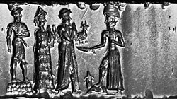
当時の行政や法整備の象徴として、印章などの工芸品が作られており、太陽神シャマシュへの献身を示す意匠などが残されています。

Old Babylonian cylinder seal, hematite. This seal was probably made in a workshop at Sippar (about 65 km or 40 mi north of Babylon on the map above) either during, or shortly before, the reign of Hammurabi.[83] It depicts the king making an animal offering to the sun god Shamash.
Linescan camera image of the cylinder seal above, reversed to resemble an impression

支配者の交代と新バビロニアの黄金時代

その後、バビロンはカッシート人、エラム人、そしてアッシリア人の支配を受けるなど、激動の時代を過ごします。アッシリアによる破壊と再建を経て、紀元前626年から539年にかけて、短期間ながら強力な新バビロニア帝国の首都として再び栄華を極めました。特にネブカドネザル2世の時代には、焼成煉瓦を用いた大規模な建築プロジェクトが進められ、都市の景観が一変しました。

A cuneiform cylinder from reign of Nebuchadnezzar II, honoring the exorcism and reconstruction of the ziggurat Etemenanki by Nabopolassar.[88]

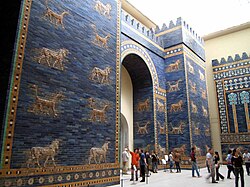
この時代の象徴が、青いタイルで装飾されたイシュタル門や、神マルドゥクを象徴する龍や牡牛のレリーフが並ぶ行列道です。これらの遺構は、当時の高度な建築技術と芸術性を今に伝えています。
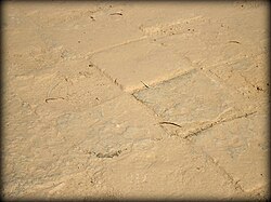
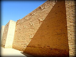
Original tiles of the processional street. Ancient Babylon, Mesopotamia, Iraq.
Mušḫuššu (sirrush) and aurochs on either side of the processional street. Ancient Babylon, Mesopotamia, Iraq.
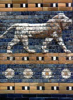
Detail of a relief from the reconstruction of the Ishtar Gate in the Pergamon Museum, Berlin
A reconstruction of the blue-tiled Ishtar Gate, Pergamon Museum, Berlin, which was the northern entrance to Babylon. It was named for the goddess of love and war. Bulls and dragons, symbols of the god Marduk, decorated the gate.

帝国の崩壊と緩やかな衰退

紀元前539年、アケメネス朝ペルシアによる征服を経て、都市はペルシア、セレウコス朝、パルティア、ローマ、ササン朝、そしてイスラム帝国へと支配者が移り変わりました。かつての栄光は次第に失われ、11世紀頃には「バベルの小さな村」と呼ばれるまでになり、最終的に放棄されました。
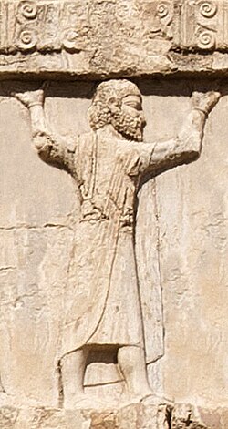
A Babylonian soldier in the Achaemenid army, c. 470 BC, Xerxes I tomb
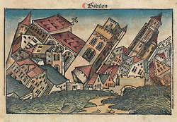
A 1493 woodcut in the Nuremberg Chronicle, depicting the fall of Babylon

考古学的調査と現代の状況

科学的発掘の始まり

1899年から1917年にかけて、ロベルト・コルデヴァイ率いるドイツ東方協会が初の科学的な発掘調査を実施しました。彼らはマルドゥク神殿や行列道、市壁などの重要な構造物を明らかにしましたが、19世紀以降に地元で焼成煉瓦が建築資材として乱掘されていたため、多くの遺構が損なわれていたことが課題となりました。
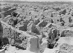
Babylon in 1932
A map of ruins in 1905, with locations and names of villages

近現代の混乱と保存への取り組み

20世紀後半、サダム・フセイン政権下で一部の村落が強制的に撤去され、古代の遺構の上にジッグラト様式の近代的な宮殿(サダム・ヒル)が建設されるという、文化財保護の観点から問題となる開発が行われました。また、2003年のイラク戦争時には、軍事作戦による遺跡の損傷が報告されました。
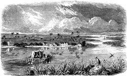
The location of the Qurnah Disaster, where hundreds of cases of antiquities from Fresnel's mission were lost in 1855
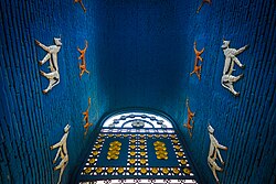
Inside the replica gate built in 1930

しかし、2009年に観光客向けに再開放され、2019年にはついにユネスコの世界遺産に登録されました。現在は、地下水位の上昇や環境変化という新たな課題に直面しながらも、人類共通の遺産として保存活動が続けられています。
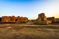
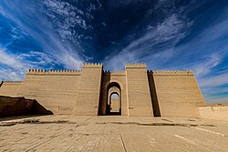
Ruins of Babylon
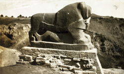
The Lion of Babylon
A gate in Babylon (2017)

バビロンの概要まとめ

バビロンの歴史的・地理的概要
項目 詳細内容
主要文化圏 メソポタミア(バビロニア)
主要建築素材 日干し煉瓦(初期)、焼成煉瓦およびビチューメン(後期)
代表的な遺構 イシュタル門、行列道、エテメンアンキ(ジッグラト)
歴史的転換点 ハンムラビの帝国建設 → 新バビロニアの繁栄 → ペルシア征服
現在のステータス ユネスコ世界文化遺産(2019年登録)

バビロンは単なる都市の跡ではなく、法典や天文学、建築術など、人類文明の基礎を築いた知の集積地でした。その姿は、後世の画家たちによっても想像的に描かれ、今なお人々の想像力を刺激し続けています。
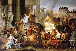
"Entry of Alexander into Babylon", a 1665 painting by Charles LeBrun, depicts Alexander the Great's uncontested entry into the city of Babylon, envisioned with pre-existing Hellenistic architecture.
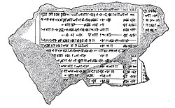
Illustration by Leonard William King of fragment K. 8532, a part of the Dynastic Chronicle listing rulers of Babylon grouped by dynasty
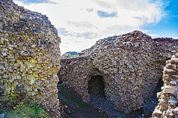
Brick structures in Babylon, 2016
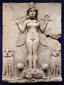
The Queen of the Night relief. The figure could be an aspect of the goddess Ishtar, Babylonian goddess of sex and love.
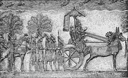
Sennacherib of Assyria during his Babylonian war, relief from his palace in Nineveh
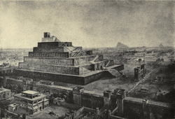
"The Walls of Babylon and the Temple of Bel (Or Babel)", by 19th-century illustrator William Simpson – influenced by early archaeological investigations
Flag of Iraq

Frequently Asked Questions

バビロンはいつ頃に建設されたのですか?

古典的な記録では紀元前23世紀頃の創建とされていますが、楔形文字の記録による確実な証拠は限られています。都市として大きく発展したのは、紀元前18世紀のハンムラビ王の時代からです。

イシュタル門とはどのようなものですか?

新バビロニア帝国の首都バビロンの北門であり、愛と戦いの女神イシュタルに捧げられました。鮮やかな青い釉薬をかけた煉瓦で造られ、神マルドゥクの象徴である龍や牡牛のレリーフで装飾されていたのが特徴です。

バビロンが世界最大の都市だった時期はありますか?

推定では、紀元前1770年〜1670年頃、および紀元前612年〜320年頃の2つの時期に、世界最大の都市であったと考えられています。人口は20万人を超えていたと推測されています。

なぜバビロンは衰退したのですか?

ペルシアやギリシャ(セレウコス朝)などの外部勢力による支配が続き、政治的な中心地としての機能を失ったためです。その後、徐々に居住者が減少し、11世紀頃には小さな村落へと縮小し、最終的に放棄されました。

現在のバビロン遺跡はどこで見ることができますか?

イラク共和国のバビル県ヒッラに位置しています。2019年にユネスコ世界遺産に登録されており、観光客向けに公開されています。

References

  1. Please see for more discussion on dating events in the , including the Sack of Babylon.

📸 フォトギャラリー

A map of Babylon, with major areas and modern-day villages
Babylon in 1932
A map of ruins in 1905, with locations and names of villages
The location of the Qurnah Disaster, where hundreds of cases of antiquities from Fresnel's mission were lost in 1855
"Entry of Alexander into Babylon", a 1665 painting by Charles LeBrun, depicts Alexander the Great's uncontested entry into the city of Babylon, envisioned with pre-existing Hellenistic architecture.
Original tiles of the processional street. Ancient Babylon, Mesopotamia, Iraq.
Mušḫuššu (sirrush) and aurochs on either side of the processional street. Ancient Babylon, Mesopotamia, Iraq.
Illustration by Leonard William King of fragment K. 8532, a part of the Dynastic Chronicle listing rulers of Babylon grouped by dynasty
Brick structures in Babylon, 2016
The Queen of the Night relief. The figure could be an aspect of the goddess Ishtar, Babylonian goddess of sex and love.
A map showing the Babylonian territory upon Hammurabi's ascension in 1792 BC and upon his death in 1750 BC
Old Babylonian cylinder seal, hematite. This seal was probably made in a workshop at Sippar (about 65 km or 40 mi north of Babylon on the map above) either during, or shortly before, the reign of Hammurabi.[83] It depicts the king making an animal offering to the sun god Shamash.
Linescan camera image of the cylinder seal above, reversed to resemble an impression
Sennacherib of Assyria during his Babylonian war, relief from his palace in Nineveh
A cuneiform cylinder from reign of Nebuchadnezzar II, honoring the exorcism and reconstruction of the ziggurat Etemenanki by Nabopolassar.[88]
Detail of a relief from the reconstruction of the Ishtar Gate in the Pergamon Museum, Berlin
A reconstruction of the blue-tiled Ishtar Gate, Pergamon Museum, Berlin, which was the northern entrance to Babylon. It was named for the goddess of love and war. Bulls and dragons, symbols of the god Marduk, decorated the gate.
A Babylonian soldier in the Achaemenid army, c. 470 BC, Xerxes I tomb
Ruins of Babylon
The Lion of Babylon
Inside the replica gate built in 1930
A gate in Babylon (2017)
A 1493 woodcut in the Nuremberg Chronicle, depicting the fall of Babylon
"The Walls of Babylon and the Temple of Bel (Or Babel)", by 19th-century illustrator William Simpson – influenced by early archaeological investigations
Flag of Iraq