地球を赤道で二分した際、南側に位置する領域が南半球です。この地域は、北半球に比べて陸地面積が少なく、表面の約80.9%が海洋に覆われているという大きな特徴があります。南極大陸のすべて、オセアニア全域、南米の約90%、そしてアフリカの約3分の1が含まれており、地球全体の陸地の32.7%を占めています。
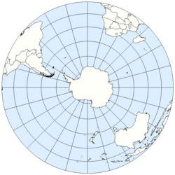
視覚的に見ると、南半球は広大な海が支配的な世界であり、北半球(水域比率60.7%)とは対照的な構成となっています。
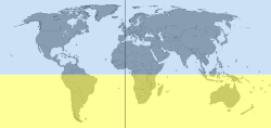
Key Facts
- 水域比率:表面の80.9%が水であり、北半球より大幅に高い。
- 人口:世界人口の約10〜12%にあたる8億5,000万人以上が居住。
- 季節:12月〜2月が夏、6月〜8月が冬となる。
- 気候:海洋の影響が強く、同緯度の北半球より穏やかな傾向がある(南極を除く)。
- 天文:南十字星やマゼラン雲など、南半球からしか見えない天体が存在する。
自然環境と科学的特性
気候と季節のメカニズム
地球の自転軸が傾いているため、南半球の季節は北半球と正反対になります。春分は9月22日または23日、秋分は3月20日または21日です。また、陸地が少なく海洋が広いため、比熱の大きい水の影響で、同緯度の北半球よりも気温の変化が緩やかで穏やかな気候になる傾向があります。ただし、南極地域だけは北極圏よりも極めて低温です。
天体観測と太陽の動き
南半球では、太陽は北側の空を通り、東から西へと移動します。このため、日時計の影は反時計回りに回転します。また、天の川の中心を含むいて座や、大マゼラン雲・小マゼラン雲といった天体が観測でき、空気が澄んでいる地域では非常に鮮明な星空を楽しむことができます。
物理現象と生態系の独自性
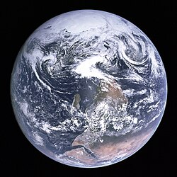
地球の自転によるコリオリの力の影響で、サイクロンや熱帯低気圧は北半球とは逆に時計回りに回転します。生態面では、ペンギンの多くがこの地域に生息しているほか、チリやオーストラリアに見られるナンキョクブナ(Nothofagus)や、オーストラリア原産のユーカリなど、独自の植生が発達しています。
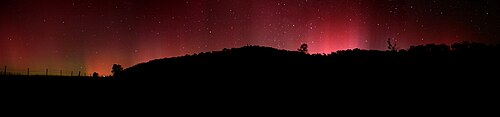
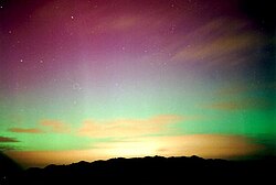
また、南半球の夜空を彩るオーロラ・オーストラリス(南極光)は、ニュージーランドやオーストラリア南部などで観測される幻想的な現象です。
人口統計と人間地理学
南半球に住む人々は約8億5,000万人で、その多くはブラジルやインドネシアなどの大国に集中しています。特にインドネシアは南半球で最も人口が多い国であり、世界で最も人口密度の高い島であるジャワ島を抱えています。また、言語面ではブラジルやアンゴラ、モザンビークなどで話されるポルトガル語が広く普及しています。
経済的な視点では、オーストラリアやニュージーランドが高い人間開発指数(HDI)を誇る一方で、アフリカの一部地域では開発途上の状況が続いており、地域間の経済格差が顕著です。主要な金融センターとしては、サンパウロ、シドニー、ジャカルタ、ヨハネスブルグ、ブエノスアイレスなどが挙げられます。

歴史と文化の痕跡
人類の居住史において、ペルー北岸のノルテ・チコ文明やカスマ・セチン文化は、紀元前3600年まで遡る最古の記念碑的文明の一つです。また、イースター島は、大航海時代以前に人間が定住した場所として世界で最も隔絶された地点の一つとされています。
地域別構成まとめ
| 区分 | 主な地域・国 | 地理的特徴 |
|---|---|---|
| 大陸 | 南極(全域)、オセアニア(全域)、南米(約90%)、アフリカ(約1/3) | 南極点を含む広大な範囲 |
| 海洋 | 南氷洋、インド洋(大部分)、南大西洋、南太平洋 | 表面の80.9%を占める水域 |
| 主要都市 | ジャカルタ、サンパウロ、キンシャサ、ブエノスアイレス | 巨大都市圏の形成 |
| 特殊地域 | ゼアランディア(沈没大陸) | ニュージーランド等を含む水没大陸 |
Frequently Asked Questions
南半球の季節はなぜ北半球と逆なのですか?
地球の自転軸が公転面に対して傾いているため、時期によって太陽光が強く当たる半球が入れ替わるからです。そのため、北半球が冬のとき、南半球は夏になります。
南半球でしか見られない星や天体はありますか?
はい。南十字星や、銀河系の伴星である大マゼラン雲、小マゼラン雲などは、南半球からのみ、あるいは南半球の方が圧倒的に観測しやすいため、象徴的な天体となっています。
南半球の気候は北半球とどう違うのでしょうか?
南半球は北半球よりも陸地が少なく海洋が広いため、海による温度調節機能が強く働きます。その結果、同緯度の地域と比較して気温の変化が緩やかで、穏やかな気候になる傾向があります。
南半球で最も人口が多い国はどこですか?
インドネシアです。国全体として南半球に多くの人口を抱えており、特にジャワ島は世界で最も人口が多い島として知られています。
南半球の台風(サイクロン)の回転方向は?
コリオリの力の影響により、南半球の低気圧やサイクロンは時計回りに回転します。これは北半球の反時計回りの回転とは正反対の動きです。
References
- "Hemisphere Map". WorldAtlas. Archived from the original on 22 April 2021. Retrieved 13 June 2014.
- Life on Earth: A - G.. 1. . 2002. p. 528. . Archived from the original on 22 January 2023. Retrieved 8 September 2016.
- "90% Of People Live In The Northern Hemisphere - Business Insider". Business Insider. 4 May 2012. Archived from the original on 19 January 2018. Retrieved 3 January 2023.
- "GIC - Article". galegroup.com. Archived from the original on 18 April 2016. Retrieved 3 January 2023.
- Granite specific heat = 0.79 and water = 4.18 J/g⋅K see .
- Kang, Sarah M.; Seager, Richard. "Croll Revisited: Why is the Northern Hemisphere Warmer than the Southern Hemisphere?" (PDF). Columbia University. Archived (PDF) from the original on 2021-09-07. Retrieved 2018-05-02.
- "Surface Ocean Currents". 's Ocean Service Education. Archived from the original on 6 July 2017. Retrieved 13 June 2014.
- Rix-Standing, Luke (2021-04-25). "World Penguin Day: 6 places you'd never have thought you could see them". The Independent. Archived from the original on 2022-03-05. Retrieved 2022-03-05.
- International Hydrographic Organization (1953). "Limits of Oceans and Seas" (PDF). Nature. 172 (4376) (3rd ed.): 484. :1953Natur.172R.484.. :10.1038/172484b0. 36029611. Archived from the original (PDF) on 8 October 2011. Retrieved 28 December 2020.
- "CIA – The World Factbook – Tanzania". Cia.gov. Archived from the original on January 9, 2021. Retrieved 11 May 2025.
📸 フォトギャラリー