Mount Rainier seen from the International Space Station
← ホームへ戻る
マウント・レーニアワシントン州カスケード山脈成層火山ラハール

マウント・レーニアの自然と火山リスクワシントン州の象徴的な名峰

🗓 2026年8月12日

アメリカ合衆国ワシントン州のピアース郡にそびえるマウント・レーニアは、カスケード山脈を代表する壮大な成層火山です。標高4,391メートルに達するこの山は、その圧倒的な存在感から地域のランドマークとなっており、マウント・レーニア国立公園として保護されています。先住民の間では「タホマ(Tahoma)」などの名称で呼ばれており、古くから神聖な山として敬われてきました。

宇宙からもその姿を確認できるほど巨大なこの山は、単なる景勝地ではなく、地質学的に非常に活動的な火山であるという側面を持っています。
Mount Rainier seen from the International Space Station

主要な事実(Key Facts)

  • 標高: 4,391メートル(北米で非常に高い卓越度を持つ山の一つ)
  • 山種: 成層火山(カスケード火山弧の一部)
  • 最終噴火: 西暦1450年
  • 気候: 山頂付近は氷帽気候(EF)に分類される極寒の地
  • 生態系: サブアルパインの野花やカスケードアカギツネなどが生息

地質学的構造と火山の脅威

マウント・レーニアは約50万年前に沈み込み帯の火山活動によって形成されました。現在は「10年火山(Decade Volcano)」に指定されており、世界的に見ても監視が必要な火山の一つとされています。最後に噴火したのは1450年ですが、内部では依然として地震活動が続いており、地質学的な休息状態にあります。
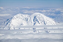
West face of Mount Rainier from an aircraft

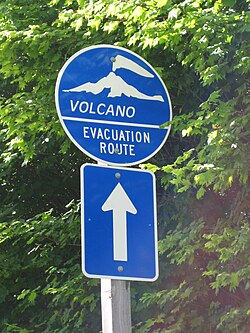
特に懸念されているのがラハール(火山泥流)です。これは火山活動や氷河の崩壊によって大量の泥と岩石が高速で流れ下る現象で、周辺地域に甚大な被害をもたらす可能性があります。そのため、地域には避難経路を示す標識が設置され、厳格なハザードマップによる管理が行われています。
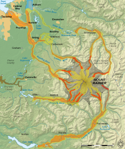
Hazard map of Mount Rainier Lava flows and pyroclastic flows Electron Mudflow-sized event (generally large in size) National Lahar-sized event (generally moderate in size) Lahars not necessarily associated with volcanism (generally small) Flooding after lahar event Potential area of inundation from failure of the Alder Dam County boundary Mount Rainier National Park boundary City
One of many emergency evacuation route signs in case of volcanic eruption or lahar around Mount Rainier
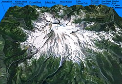
Three-dimensional representation of Mount Rainier

氷河とダイナミックな地形

この山は、米国本土で最大級の氷河系を擁しています。ニスカリー氷河などの巨大な氷河が山体を削り、独特の険しい地形を作り出しています。しかし、近年の気候変動の影響で氷河の後退が進んでおり、かつて氷に覆われていた岩場が露出するなど、山の形状自体が変化し続けています。
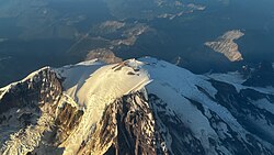
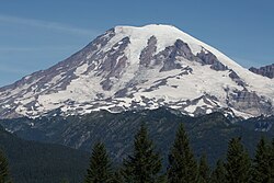
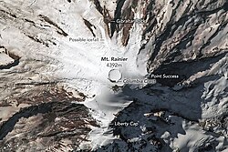
The summit of Mount Rainier showing summit calderas and the mountain's glaciers
Nisqually Glacier is seen clearly from southeast of the mountain
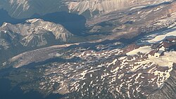
The rocky area left behind after the retreat of the North Mowich Glacier seen in July 2024

登山とアウトドア・レクリエーション

登山者にとってマウント・レーニアは挑戦的な目的地です。1870年にハザード・スティーブンスとP.B.ヴァン・トランプによって初登頂されました。現在では「ディサポイントメント・クリーバー」などのルートが知られていますが、氷河のクレバスや急激な天候変化など、常に危険が伴います。
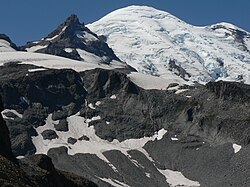
Little Tahoma Peak to the left of Mount Rainier, from Panhandle Gap
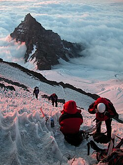
Climbers on Ingraham Glacier, above Little Tahoma

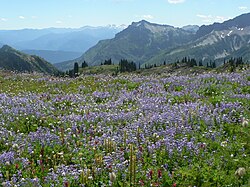
多くの登山者は、標高約3,080メートルに位置するキャンプ・ミュアをベースキャンプとして利用します。また、登山以外にも、パラダイス地域で見られる色鮮やかな高山植物の草原は、観光客に絶大な人気を誇ります。
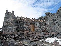
Camp Muir is commonly used by those attempting to summit Mount Rainier
Subalpine wildflower meadow in Paradise region of Mount Rainier

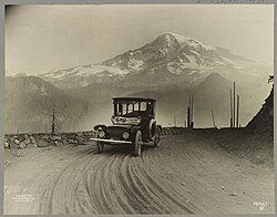
冬には厳しい寒さと深い雪に覆われますが、そこにはカスケードアカギツネのような野生動物が適応して生息しています。また、歴史的に見れば、1919年には電気自動車によるプロモーションツアーが行われるなど、古くから人々を惹きつけてきました。
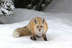
A Cascade red fox active during Paradise's long winter
A 1919 Detroit Electric car on a promotional tour from Seattle to Mt. Rainier, with the mountain in the background.
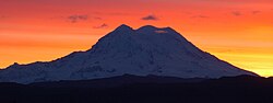
Mount Rainier sunset

マウント・レーニアの基本データまとめ

マウント・レーニアの地理・地質概要
項目 詳細内容
最高地点(標高) 4,391 m (14,406 ft)
山種 成層火山
親山脈 カスケード山脈
保護区分 マウント・レーニア国立公園
主要なリスク ラハール(火山泥流)、地震、氷河崩落

Frequently Asked Questions

マウント・レーニアは現在も活動している火山ですか?

はい、地質学的には活火山に分類されます。最後に噴火したのは1450年ですが、現在も地震活動が観測されており、米国地質調査所(USGS)によって厳重に監視されています。

「ラハール」とは具体的にどのような危険があるのでしょうか?

ラハールとは、火山灰や岩石が水と混ざり合って流れる泥流のことです。氷河の融解や噴火が引き金となり、非常に速い速度で山麓の街や集落を飲み込む可能性があるため、避難計画が策定されています。

登山をする際に最も一般的なルートはどこですか?

比較的登頂しやすいルートとして、岩と氷を登る「ディサポイントメント・クリーバー(Disappointment Cleaver)」経由のルートが広く利用されています。

山頂の気候はどのような状態ですか?

山頂は「氷帽気候(EF)」に属しており、一年を通じて非常に低温です。年間の平均最高気温が氷点下になる月が多く、極めて厳しい環境となっています。

先住民による元の名称は何ですか?

ルシュートシード語では「təqʷubəʔ」や「xʷaq̓ʷ」、カウルリッツ語では「təx̣ʷúma」や「təqʷúmen」、ヤカマ語では「Tax̱úma」など、複数の名称で呼ばれていました。

References

  1. Indigenous peoples around the mountain have names for it in their languages:
    • : təqʷubəʔ and xʷaq̓ʷ
    • : təx̣ʷúma and təqʷúmen
    • : Tax̱úma
  2. Before 2014, Mount Rainier's icecap at the Columbia Crest was the highest point on the mountain, and was surveyed at 14,410 feet (4,390 m) in 1956. Due to , the Columbia Crest has melted down to a height of 14,394.6 feet (4,387.5 m), while Mount Rainier's Southwest Rim was measured at 14,406.3 feet (4,391.0 m), which would make it the new highest point on the volcano.
  3. The 1999 survey was based on the , but the result was converted to NGVD29 by the original authors for comparison to previous values.

📸 フォトギャラリー

Mount Rainier seen from the International Space Station
West face of Mount Rainier from an aircraft
Little Tahoma Peak to the left of Mount Rainier, from Panhandle Gap
Hazard map of Mount Rainier Lava flows and pyroclastic flows Electron Mudflow-sized event (generally large in size) National Lahar-sized event (generally moderate in size) Lahars not necessarily associated with volcanism (generally small) Flooding after lahar event Potential area of inundation from failure of the Alder Dam County boundary Mount Rainier National Park boundary City
The summit of Mount Rainier showing summit calderas and the mountain's glaciers
One of many emergency evacuation route signs in case of volcanic eruption or lahar around Mount Rainier
Three-dimensional representation of Mount Rainier
Nisqually Glacier is seen clearly from southeast of the mountain
The rocky area left behind after the retreat of the North Mowich Glacier seen in July 2024
A 1919 Detroit Electric car on a promotional tour from Seattle to Mt. Rainier, with the mountain in the background.
Mount Rainier sunset
Climbers on Ingraham Glacier, above Little Tahoma
Camp Muir is commonly used by those attempting to summit Mount Rainier
Subalpine wildflower meadow in Paradise region of Mount Rainier
A Cascade red fox active during Paradise's long winter