1991年にフィリピンのルソン火山弧で発生したピナトゥボ山の噴火は、20世紀においてアラスカのノバルプタ噴火に次ぐ世界第2位の規模を記録した壊滅的な自然災害でした。この噴火は単なる局地的な災害に留まらず、地球規模の気候に影響を与えるほどの甚大なエネルギーを放ちました。
噴火の始まりは4月2日の水蒸気爆発(マグマが地下水と接触して起こる爆発)であり、その後数ヶ月にわたって活動が激化しました。地震計による監視が進む中、6月に入ると地震の回数が増加し、山頂付近に小さな溶岩ドームが形成されるなど、破滅的なクライマックスへと向かっていきました。
Key Facts
- 噴火期間:1991年4月2日 〜 9月2日
- 火山爆発指数 (VEI):6(極めて大規模な噴火)
- 人的被害:死者約847名、避難者約2万人、ホームレス化した人々約1万人
- 地形の変化:山頂が崩落し、直径2.5kmのカルデラが形成。標高が1,745mから1,486mへ低下
- 気候への影響:大量の火山灰とエアロゾルが放出され、地球規模の気温低下を招いた
噴火の激化とクライマックス
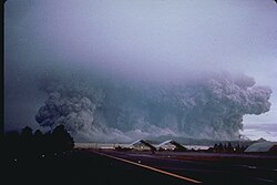
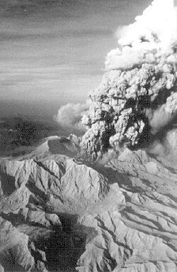
6月12日に最初の本格的な噴火が起こり、高さ19kmに達する噴煙柱が立ち上がりました。その後、地震活動はさらに激しさを増し、6月15日にはついに最大規模の噴火(クライマックス)を迎えます。このとき、ガスを大量に含んだマグマが地表に達し、噴煙は成層圏の高さ40kmまで到達しました。
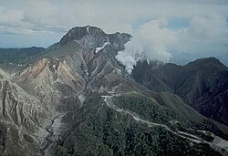
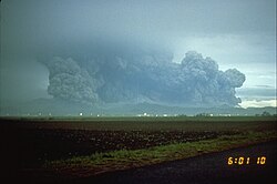
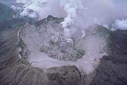
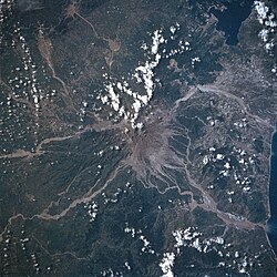
この爆発的な噴火により、大量の火山灰と軽石が周囲を覆い尽くし、猛烈な速度で流下する火砕流(高温のガスと火山砕屑物の混合流)が深い谷を埋め立てました。堆積物の厚さは最大で200mに及び、山頂部は自重に耐えきれず崩落して巨大なカルデラとなりました。
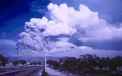
さらに不幸だったのは、噴火とほぼ同時に台風「ユニャ(現地名:ディディング)」が上陸したことです。台風による豪雨が火山灰と混ざり合い、泥流であるラハール(火山泥流)を発生させ、壊滅的な被害を拡大させました。
避難計画と人道的な対応
当局は危険度に応じて3つの避難区域を設定しました。最内圏の10km圏内から、最大40km圏内(クラーク空軍基地やアンヘレス市を含む)までを対象とし、段階的に避難指示を出しました。特に山麓に住んでいた先住民族アエタの人々は、4月の最初の爆発時から自発的に移動を開始し、噴火までに何度も移住を繰り返しました。
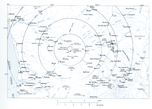
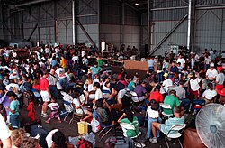
最終的に6月15日までに約6万人が避難し、多くはメトロ・マニラなどの避難キャンプへ身を寄せました。国際社会からも多大な支援が寄せられ、国連機関やオーストラリア、ドイツ、米国などの各国から資金や物資の援助が行われました。
社会・経済への甚大な打撃
噴火による経済的損失は計り知れず、特に農業への打撃が深刻でした。約800平方キロメートルの水田が破壊され、約80万頭の家畜や家禽が犠牲となりました。農業分野だけで約15億ペソの損失が出たと推定されています。
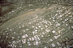
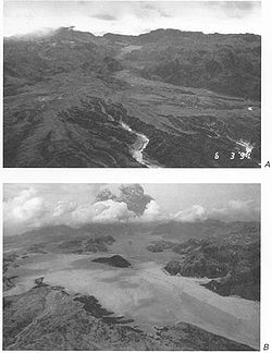
また、地域経済の柱であった産業も停滞し、地域国内総生産(GRDP)は前年比で3%以上減少しました。インフラの復旧には、道路や橋の再建、河川システムの整備など、多額の政府予算と国際的な融資(JICAや世界銀行など)が投入されました。
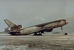
航空業界への影響も甚大で、降り積もった火山灰によって航空機が深刻なダメージを受けました。
地球環境への影響とその後
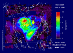
ピナトゥボ山の噴火は、局地的な災害に留まらず、地球全体の気温を低下させるという現象を引き起こしました。放出された大量の二酸化硫黄が成層圏で硫酸エアロゾルとなり、太陽光を遮ったためです。
| 項目 | 詳細内容 |
|---|---|
| 噴火形式 | 水蒸気爆発およびウルトラ・プリニー式噴火 |
| 最大噴煙高度 | 約34km 〜 40km |
| 地形変化 | 山頂崩落による直径2.5kmのカルデラ形成 |
| 農業被害 | 水田800km²喪失、家畜約80万頭死亡 |
| 経済損失 | 作物・財産被害 約3.74億ドル(1991年当時) |
Frequently Asked Questions
ピナトゥボ山の噴火はなぜこれほど大規模だったのですか?
大量のガスを含むマグマが地表に達し、爆発的なエネルギーを放つ「ウルトラ・プリニー式噴火」という非常に強力な形式であったためです。これにより、火山灰が成層圏まで達し、広範囲に影響を及ぼしました。
「ラハール」とは何ですか?
火山灰や岩石が雨水や洪水と混ざり合って流れる「火山泥流」のことです。1991年の噴火では、台風の豪雨が火山灰と混ざったことで大規模なラハールが発生し、多くの家屋やインフラを破壊しました。
噴火によって地球の気温が下がったというのは本当ですか?
はい。噴火によって放出された二酸化硫黄が成層圏で硫酸エアロゾルとなり、太陽光を反射したため、地球全体の平均気温が一時的に低下したことが観測されています。
噴火後の山頂はどうなりましたか?
噴火によって地下のマグマが大量に失われたため、山頂が崩落して直径2.5kmのカルデラ(陥没地形)が形成されました。その後、このカルデラの中にピナトゥボ湖が形成されました。
避難した人々への支援はどう行われましたか?
フィリピン政府による再定住計画や農業・産業の自立支援プログラムが実施されたほか、国連(UNDP, UNICEF, WHO, WFP)や世界各国の政府から多額の資金援助や物資提供が行われました。
References
- "Pinatubo". . . Archived from the original on April 6, 2023. Retrieved January 21, 2020.
- "The Cataclysmic 1991 Eruption of Mount Pinatubo, Philippines". U.S. Geological Survey Fact Sheet 113-97. U.S. Geologic Survey. 1997. Archived from the original on August 25, 2013. Retrieved January 21, 2020.
- Rosenberg, Matt (August 5, 2007). "The Volcanic Mount Pinatubo Eruption of 1991 that Cooled the Planet". About.com Geography. Archived from the original on October 13, 2007. Retrieved March 16, 2024.
- Department of the Interior, U.S. Geological Survey (June 13, 2016). "Remembering Mount Pinatubo 25 Years Ago: Mitigating a Crisis". www.usgs.gov. Archived from the original on December 4, 2021. Retrieved January 27, 2020.
 This article incorporates text from this source, which is in the .
 - USGS. "Earthquake Information for 1990". Archived from the original on December 6, 2009. Retrieved March 6, 2010.
- "USGS Earthquake Magnitude Policy". Archived from the original on May 4, 2016.
- Factoran, Fulgencio Jr. S. (2001). "The July 16 Luzon Earthquake: A Technical Monograph". Inter-Agency Committee for Documenting and Establishing Database on the July 1990 Earthquake. . Archived from the original on September 7, 2008. Retrieved January 7, 2009.
- "Chronology of the 1991 Pinatubo eruption, Philippines". Volcano Discovery. Archived from the original on May 28, 2012. Retrieved July 10, 2019.
- Lastovicka, Jan (2009). Geophysics and Chemistry – Volume II. EOLSS Publications. p. 162. . Archived from the original on August 31, 2024. Retrieved July 10, 2019.
- Sigurdsson, Haraldur; Houghton, Bruce; Rymer, Hazel; Stix, John; McNutt, Steve (1999). Encyclopedia of Volcanoes. Academic Press. p. 1193. . Archived from the original on August 31, 2024. Retrieved July 10, 2019.
 This article incorporates text from this source, which is in the .
📸 フォトギャラリー