火星の地表を眺めると、そこには地球を遥かに凌ぐ規模の火山地形が広がっています。1972年のマリナー9号による探査以来、私たちはこの赤い惑星が極めて活発な火山活動の歴史を持っていたことを知りました。広大な溶岩平原から、太陽系で最大とされる巨大火山まで、その多様な地形は火星の内部構造と進化の過程を物語っています。
火星の火山活動は、約37億年以上前のノアキス期から、5億年より新しいアマゾニア期に至るまで、惑星の歴史を通じて断続的に続いてきました。一部の研究者は、火星が現在も地質学的に生きている可能性を示唆しています。地球と同様に、火星も分化した惑星であり、コンドライトに近い組成を持つため、地球で起きているマグマのプロセスや火成岩の分類をそのまま適用することが可能です。
![Mariner 9 image of Ascraeus Mons.[1] This is one of the first images to show that Mars has large volcanoes.](/images/78/ce/78ce3fbadfce4aef31d11bce72a515577299150fb0ac478418a77e96ab3f6124.jpg)
Key Facts
- 太陽系最大の火山: オリンポス山は高さ約21kmに達し、地球のどの火山よりも巨大です。
- 長期的な活動: 火山活動は数十億年にわたり継続しており、現在も活動している可能性があります。
- 主要な火山地帯: タルシス地域とエリュシオン地域に大規模な火山が集中しています。
- 溶岩の性質: 主に流動性の高い玄武岩質の溶岩によって形成されたシールド火山が多く見られます。
- 氷との相互作用: 溶岩が氷や水と接触することで、特有の爆発的噴火や地形が形成されました。
火山活動の基礎メカニズム
火山活動とは、惑星内部で生成されたマグマが地殻を突き抜けて表面に噴出する現象です。このプロセスを通じて、惑星は内部に蓄積された熱を外部に放出します。噴出物は、溶融した岩石である溶岩、火山灰やテフラと呼ばれる破砕物質、そしてさまざまなガスで構成されています。
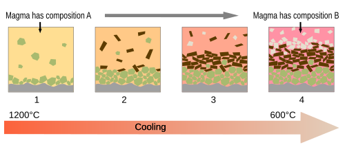
マグマが冷却される過程では、「分化結晶作用」という現象が起こります。これは、温度低下に伴い異なる鉱物が順番に結晶化することで、残った液体(メルト)の組成が変化していく仕組みです。例えば、最初にカンラン石が結晶化し、次に輝石、そして斜長石へと続きます。これにより、マグマ溜まりの底部には累積岩が形成されます。
火星の土壌分析(CheMinによるX線回折)では、斜長石、輝石、カンラン石などの鉱物が検出されており、これは地球のハワイにある火山に見られる「風化した玄武岩質土壌」に似た特徴を持っています。
![First X-ray diffraction view of Martian soil – CheMin analysis reveals minerals (including feldspar, pyroxenes and olivine) suggestive of "weathered basaltic soils" of volcanoes in Hawaii (Curiosity rover at "Rocknest", 2012).[18] Each ring is a diffraction peak that corresponds to a specific atom-atom distance, which are unique enough to identify minerals. Smaller rings corresponds to larger features and vice versa.](/images/3b/08/3b08b4fdcf4ca67376e727d3e1990d90306016f5a51b165f7dd8f2ea4e43a41a.jpg)
タルシス火山地域:巨大火山の集積地
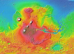
火星の赤道付近に位置するタルシス地域は、巨大な膨らみ(タルシス・バルジ)を形成しており、ここには驚異的な規模の火山が集中しています。
タルシス三山(Tharsis Montes)
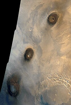
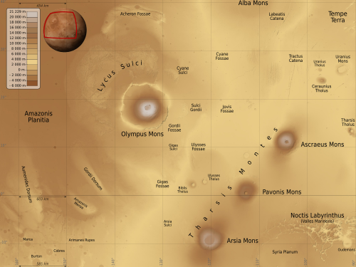
赤道付近に並ぶ3つのシールド火山で、それぞれ直径数百キロメートル、高さ14〜18kmに及びます。南のアルシア山は直径130kmの巨大な山頂カルデラを持ち、中央のパボニス山は深さ約5kmに達する二重カルデラを備えています。北のアスクライオス山は複雑なカルデラ構造を持ち、火星の歴史の大部分にわたって噴火を繰り返していたと考えられています。
オリンポス山(Olympus Mons)
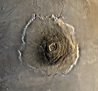
タルシス地域の北西に位置するオリンポス山は、太陽系で最も高く、かつ比較的新しい火山です。標高は約21kmに達し、山頂には6つのカルデラが重なり合った複雑な構造(幅72×91km、深さ3.2km)があります。非常に緩やかな傾斜(平均4〜5度)を持つシールド火山であり、数千回にわたる低粘度の溶岩流の積み重ねによって形成されました。山の麓には最大8kmの高さの断崖(エスカープメント)が存在し、あたかも台座の上に火山が乗っているような形状をしています。
アルバ山(Alba Mons)
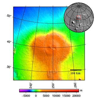
タルシス北部に位置するアルバ山は、他の火山とは全く異なる形態をしています。傾斜が極めて緩やか(平均約0.5度)で、溶岩流が南北に2000km、東西に3000kmという広大な範囲に広がっています。この特異な形成理由は、惑星の反対側にあるヘラス盆地への巨大衝突による地殻の弱体化が影響したという説があります。
エリュシオン火山地域とその他の地形
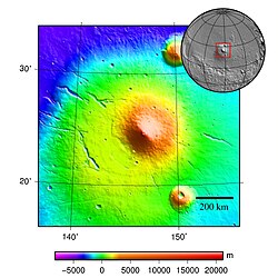
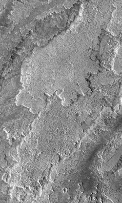
タルシス以外にも、エリュシオン地域などの火山地帯が存在します。ここでの最大峰であるエリュシオン山は高さ14km、直径375kmの円錐形の火山です。また、ヘカテス山は火山灰などの侵食されやすい物質で構成されていると考えられており、表面に多くのチャネル(流路)が見られます。
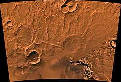
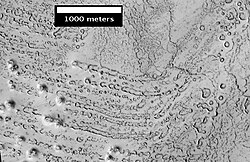
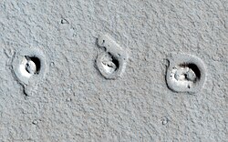
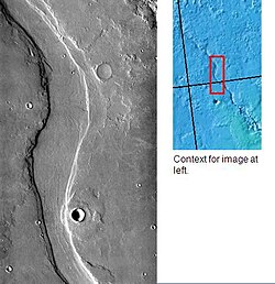
火星の火山活動は、単なる溶岩の噴出に留まりません。溶岩が水に富んだ地盤や氷の上を流れた際、水蒸気爆発が起こり「ルートレス・コーン(根のない円錐丘)」と呼ばれる特有の地形が形成されました。また、エリュシオン山周辺のフラド・バリスのような谷は、噴火によって地下氷や表面氷が融解したことで形成された可能性があります。
火星の地質学的特徴まとめ
| 火山名 | 地域 | 特徴 | 推定高さ/規模 |
|---|---|---|---|
| オリンポス山 | タルシス北西 | 太陽系最大、緩やかな傾斜のシールド火山 | 約21 km |
| タルシス三山 | タルシス赤道付近 | 3つの巨大シールド火山が並列 | 14 〜 18 km |
| アルバ山 | タルシス北部 | 極めて広大な面積と非常に緩やかな傾斜 | 高さ1.5 km / 幅3000 km |
| エリュシオン山 | エリュシオン | 円錐形のプロファイルを持つシールド火山 | 約14 km |
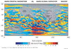
火星の地殻磁気などの研究からは、かつての地質学的ダイナミズムが示唆されており、地球のようなプレートテクトニクスの有無についても議論が続いています。
Frequently Asked Questions
火星の火山が地球よりも巨大になったのはなぜですか?
火星には地球のようなプレートテクトニクス(地殻プレートの移動)がないと考えられています。そのため、ホットスポット(マグマの供給源)の上に火山が固定され、数百万年以上にわたって同じ場所に溶岩が積み重なり続けたため、極めて巨大な山が形成されました。
火星で現在も火山活動は起きているのでしょうか?
確定的な証拠はありませんが、地質学的に新しい溶岩流の痕跡や、メタンガスの検出などのデータから、地下で依然として火山活動が続いている可能性を検討している研究者が多くいます。
「ルートレス・コーン」とはどのような地形ですか?
溶岩流が氷や水を含んだ地表を覆った際、下層の水が急激に加熱されて水蒸気爆発を起こし、地表に噴出したことで形成された円錐形の丘です。マグマの通り道(火道)が直接つながっていないため、「根のない」と呼ばれます。
火星の火山はどのような岩石でできていますか?
主に玄武岩質の岩石で構成されています。これは地球の海洋底やハワイの火山に見られる岩石と似ており、流動性の高いマグマから形成されたことを示しています。
References
- "History". www.jpl.nasa.gov. Archived from the original on 3 June 2016. Retrieved 3 May 2018.
- Head, J.W. (2007). The Geology of Mars: New Insights and Outstanding Questions in The Geology of Mars: Evidence from Earth-Based Analogs, Chapman, M., Ed; Cambridge University Press: Cambridge UK, p. 10.
- Masursky, H.; Masursky, Harold; Saunders, R. S. (1973). "An Overview of Geological Results from Mariner 9". J. Geophys. Res. 78 (20): 4009–4030. :1973JGR....78.4031C. :10.1029/JB078i020p04031.
- Carr, Michael H. (1973). "Volcanism on Mars". Journal of Geophysical Research. 78 (20): 4049–4062. :1973JGR....78.4049C. :10.1029/JB078i020p04049.
- Michalski, Joseph R.; Bleacher, Jacob E. (3 October 2013). "Supervolcanoes within an ancient volcanic province in Arabia Terra, Mars". . 502 (7469): 46–52. :2013Natur.502...47M. :10.1038/nature12482. :2060/20140011237. 24091975. 4152458.
- , p. 43
- "Hunting for young lava flows". Geophysical Research Letters. Red Planet. 1 June 2011. Archived from the original on 4 October 2013. Retrieved 4 October 2013.
- "An Ancient Meteorite Is The First Chemical Evidence of Volcanic Convection on Mars". Meteoritics & Planetary Science. ScienceAlert. 11 May 2020.
- Carr, 2006, p. 44.
- Wilson, L. (2007). Planetary Volcanism in Encyclopedia of the Solar System, McFadden, L.-A. et al., Eds., Academic Press: San Diego, CA, p. 829.
📸 フォトギャラリー