アメリカ西部の広大な大地に位置するネバダ州は、その過酷な自然環境と豊かな地下資源によって、独自のダイナミックな歴史を歩んできました。かつては「埋もれた希望の美しい砂漠」と称された時代もありましたが、鉱山ブームやギャンブルの合法化を経て、現在は世界的に有名な観光都市を抱える州へと変貌を遂げています。
Key Facts
- 州の愛称: 「シルバーステート(銀の州)」として知られる。
- 州制への道: 1864年10月31日にアメリカ合衆国の36番目の州となった。
- 経済の変遷: 銀・金の採掘から始まり、後にギャンブルと観光業が主軸となった。
- 人口の急増: 1930年に約5,000人だったラスベガスは、2013年までに200万人を超える規模に成長した。
- 特異な法整備: 1931年のギャンブル合法化と、全米で最も緩やかな離婚法が発展を後押しした。
太古の記憶と初期の探検
ネバダの歴史は、州制よりも遥か昔に遡ります。グレートベースン地域には、北米で最古級の岩絵(ペトログリフ)が存在しており、その年代は10,500年から14,800年前と推定されています。
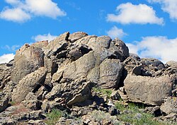
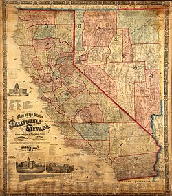
ヨーロッパ人の足跡は1770年代、スペイン出身のフランシスコ・ガルセス神父によって刻まれました。その後、この地はスペイン帝国の「新スペイン」の一部となり、1804年にはアルタ・カリフォルニア州に組み込まれました。1821年のメキシコ独立後はメキシコ領となりますが、1848年の米墨戦争とグアダルーペ・イダルゴ条約を経て、最終的にアメリカ合衆国の領土となりました。
州制への急ぎ足と「銀の時代」
1860年代、バージニアシティでコムストック鉱脈という巨大な銀鉱床が発見されると、爆発的な鉱山ブームが到来しました。この経済的価値と、南北戦争下での政治的思惑(エイブラハム・リンカーン大統領の再選に向けた選挙人票の確保)が重なり、ネバダは異例の速さで州制への移行を進めました。
1864年、州憲法が電信で議会に送信されました。これは当時、最大かつ最高額の通信記録となりました。州制移行後も、境界線の変更が何度か行われ、特に南部の境界拡大は、地域の金鉱発見に伴う管理体制の強化を目的としていました。
![The Nevada 1861 territory boundary (blue) changed three times: 1864 statehood shifted eastern border from 39th to 38th meridian, 1866 May 5; east border (pink) moved eastward 53.3 mi (85.8 km), from the 38th to 37th meridian, and 1867 January 18; south boundary (yellow) moved from the 37th parallel north southward to the current boundary (14 Stat. 43)[5]](/images/be/fd/befd11bd6d248078add58c44207ec7574d0ddfb7949dc30155ad2ea824bb862c.png)
鉱山街の栄枯盛衰
19世紀後半から20世紀初頭にかけて、トノパやゴールドフィールド、ライオライトなどで金や銀の採掘が盛んになり、多くの人々が富を夢見て集まりました。例えばゴールドフィールドは、1903年にはわずか36人だった人口が、1908年には25,000人を超える州最大の都市へと急成長しました。
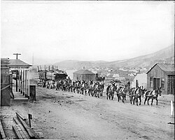
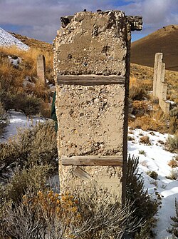
しかし、資源の枯渇とともにこれらの街は急速に衰退しました。かつての賑わいは消え、現在は廃墟となったミル(鉱石処理場)などが当時の面影を伝えています。
20世紀の転換点:ギャンブルと近代化
20世紀初頭、社会改革を目指す動きもありましたが、1910年代の経済崩壊により人口が4分の1減少するなど、州は深刻な不況に陥りました。この状況を打破したのが、1931年のギャンブル合法化です。
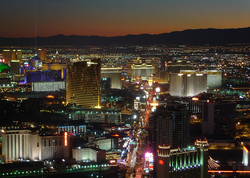
交通インフラの整備、特にカリフォルニア州の都市圏からのアクセス向上と、簡便な離婚手続き(リノでの「クイック離婚」)が相まって、ネバダは再び活気を取り戻しました。これにより、ラスベガスを中心とした爆発的な人口増加と経済発展が実現しました。
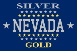
また、州の象徴として1905年から1915年まで使用された旗など、独自のアイデンティティを形成していきました。
軍事利用と科学的挑戦
地理的な隔離性と広大な土地を持つネバダは、軍事拠点としても重要視されました。第二次世界大戦中には多くの陸軍航空基地が建設され、戦後は1951年からネバダ試験場での核実験が開始されました。1,000回以上の核爆発が行われたこの地は、後にユッカ山核廃棄物処分場の計画地としても議論されることになります。
ネバダ州の基本データまとめ
| 項目 | 内容 | 決定・制定年 |
|---|---|---|
| 州の愛称 | シルバーステート (The Silver State) | - |
| 州のモットー | All For Our Country | 1866年 |
| 州花 | セージブラシ | 1917年 |
| 州木 | シングルリーフ・ピニョン | 1953年 |
Frequently Asked Questions
なぜネバダ州は急いで州制になったのですか?
主な理由は政治的な戦略です。南北戦争中の1864年、エイブラハム・リンカーン大統領の再選を確実にするための選挙人票を確保し、共和党の議会多数派を維持することを目的として、州制への移行が急がれました。
「シルバーステート」という愛称の由来は何ですか?
1859年にバージニアシティで発見されたコムストック鉱脈をはじめとする、大規模な銀鉱山ブームによって州の経済が発展したことに由来しています。
ラスベガスが急成長した要因は何ですか?
1931年のギャンブル合法化に加え、カリフォルニア州などの大都市からの交通アクセスが改善されたこと、そして全米で最も緩やかな離婚法が整備されたことで、観光客と移住者が急増したためです。
ネバダ州での核実験はいつ行われていましたか?
1951年にネバダ試験場で開始されました。1962年まで大気圏内での爆発が行われ、その後は地下核実験へと移行し、1992年に最後の爆発が実施されました。
かつての鉱山街は今どうなっていますか?
多くの街が資源の枯渇とともに衰退しました。ゴールドフィールドやゴルコンダのように、かつての繁栄を伝える廃墟や少数の施設だけが残り、現在は牧場や農場、あるいは小さな停留所となっている場所がほとんどです。
References
- Michael Green, "Abraham Lincoln, Nevada, and the Law of Unintended Consequences," Nevada Historical Society Quarterly, Summer 2009, Vol. 52#2 pp. 85–108
- Wilbur S.. Shepperson, "Nevada: Beautiful Desert Of Buried Hopes," Nevada Historical Society Quarterly, Dec 1991, Vol. 34# 4, pp. 439–465
- William D. Rowley, "People of Good Hope in the Land of Nod," Nevada Historical Society Quarterly, Mar 1999, Vol. 42#1 pp. 3–20
- Louise L. Schiavone, "Vegas Revisited," Mortgage Banking Vol. 69#12 (September 2009) pp. 48+.
- Gannett, Henry (1855). Boundaries of the United States. Washington, Govt. Print. Off.
- (1916). Physiographic Subdivision of the United States. Vol. 3. of the . pp. 17–22. :10.1073/pnas.3.1.17. 1091163. 16586678. Retrieved 2010-04-17.
{{}}:|work=ignored () - GoodReads.com book review of: Hulse, James W (2009). Nevada's Environmental Legacy: Progress or Plunder. Reno: . .
- Noble, Scotchmoor, Springer (2005); "Paleontology and geology".
- Murray, Marian (1974). Hunting for Fossils: A Guide to Finding and Collecting Fossils in All 50 States. Collier Books. p. 348. .
- Cutright, Emerson (19 July 2020). "Explore One Of The Country's Richest Fossil Beds At Ice Age Fossils State Park In Nevada". Only In Your State. Retrieved 23 August 2021.
📸 フォトギャラリー