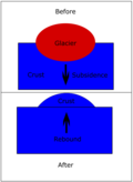
かつての氷河期、地球の広大な領域は数キロメートルにも及ぶ厚い氷床に覆われていました。この想像を絶する重量は、地球の表面を押し下げ、地殻を歪ませる原因となりました。しかし、氷が溶けてその重みが取り除かれると、押し下げられていた大地が再びゆっくりと上昇し始めます。この現象を氷河後リバウンド(または地殻均衡リバウンド)と呼びます。
このプロセスは単なる局所的な現象ではなく、地球全体の地殻変動や海面レベルに影響を与えるダイナミックな地球物理学的プロセスです。氷床の消失に伴う地殻の変形と復元は、「氷河アイソスタシー」という大きなサイクルの一部として理解されています。
Key Facts
- 定義: 氷河期の氷床による荷重がなくなった後、地殻が元の高さに戻ろうとする隆起現象。
- メカニズム: 粘弾性を持つマントル物質が、荷重の除去に伴い元の位置へゆっくりと戻ることで発生する。
- 時間軸: 氷が消えた直後の弾性的な反応の後、数千年から数万年かけて緩やかに進行する。
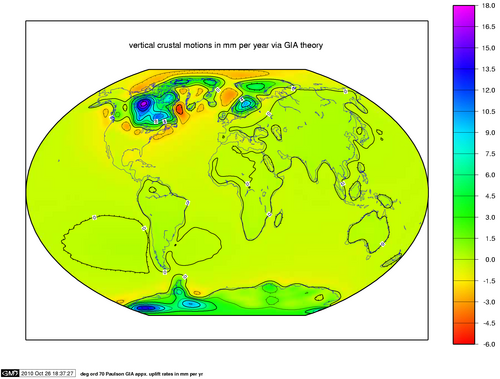
- 影響範囲: 北欧、北米、南極などで顕著だが、海面変動を通じて地球規模で影響が及ぶ。
- 現代の速度: 地域によっては年間1cm以下の速度で現在も隆起が続いている。
地殻が隆起する仕組みとプロセス
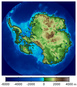
約2万年前の最終氷期最盛期には、北欧や北米、南極などの地表に最大3kmに達する氷床が存在していました。この巨大な質量が地殻を押し下げると、その下の粘弾性マントル(ゆっくりと流動する性質を持つ地球内部の層)が周囲に押し出されました。これが「アイソスタシーによる沈降」です。
氷河が後退し荷重がなくなると、隆起は2つの段階を経て進みます。まず、地殻の弾性反応により、氷が消えた直後に急速な上昇が起こります。その後、粘性の高いマントル物質が再び元の場所へ流れ戻ることで、非常に緩やかな上昇が始まります。マントルの粘性が極めて高いため、完全に平衡状態に戻るまでには数万年という膨大な時間を要します。
現代における観測例
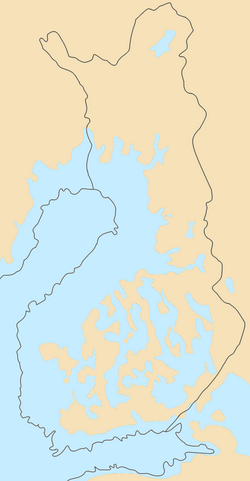
現代でもこの現象は続いており、フィンランドではGPSデータにより、国土面積が年間約7平方キロメートルずつ拡大していることが確認されています。研究によれば、このリバウンドは今後少なくとも1万年以上は続くと予測されています。
地球環境への多角的な影響
垂直方向の地殻変動と地形の変化
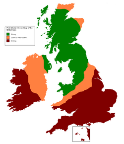
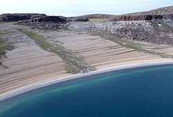
リバウンドによる隆起は、地域の地形を劇的に変えます。例えば、北欧のボトニア湾にあるクヴァルケン(ユネスコ世界自然遺産)は、この現象を象徴する地域として知られています。また、イギリスでは北部のスコットランドが隆起する一方で、南部のイングランドが相対的に沈降しており、将来的に南部での洪水リスクが高まると懸念されています。
海面レベルへのグローバルな影響
氷河最盛期には、大量の水が氷として陸上に固定されていたため、世界的な海面は約120メートルも低下していました。これにより、現在は海である場所が陸地となり、アジアとインドネシアを結ぶ「スンダランド」や、欧州と英国を結ぶ「ドッガーランド」、さらにはシベリアとアラスカを結ぶ陸橋が存在し、人類や動物の移動を可能にしていました。
地表の傾斜と水系への影響
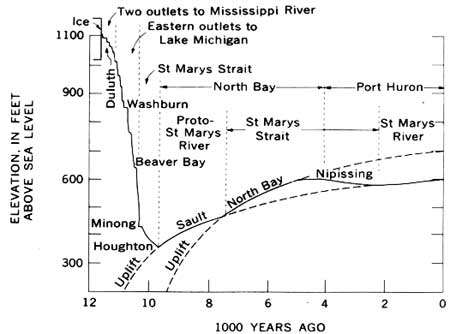
隆起の速度は場所によって異なるため、地表に「傾き(ティルト)」が生じます。氷床の中心に近いほど速く隆起するため、湖の底が傾き、水流の方向が変わることがあります。フィンランドのピエレネン湖では、この傾斜によって排水口が変わり、新しい河川(ピエリヨキ川)が形成されました。このような変動は、現代の水資源管理においても重要な検討事項となります。
地質学的ストレスと地球内部への影響
地震と火山活動への関与
地殻への荷重変化は、内部のストレス状態を大きく変えます。プレート境界から離れた地域(カナダ東部や北欧など)で発生する「プレート内地震」の一部は、この氷河後リバウンドによるストレスの解放が引き金になったと考えられています。一般的に、巨大な氷の荷重は地震を抑制しますが、急速な氷河の後退は地殻の不安定化を招き、既存の断層を再活性化させます。
また、火山活動にも影響を与えます。氷床の重圧はマグマの生成を抑制しますが、除荷(荷重の除去)によって圧力が下がると、アイスランドやグリーンランドなどの地域で溶融量が増え、火山活動が20〜30倍に活性化することがあります。
地球の形状と重力場
マントル物質が元の位置に戻ることで、地球全体の形状がわずかに変化し、扁平率が減少します。これは地球の重力場の長波長成分に影響を与え、精密な地球物理学的観測の対象となっています。
まとめ:氷河後リバウンドの概要
| 項目 | 氷河最盛期(沈降期) | 氷河後退後(リバウンド期) |
|---|---|---|
| 地殻の状態 | 氷床の重量で押し下げられる | 荷重が消え、ゆっくりと上昇する |
| マントルの動き | 荷重地域から外側へ流出 | 再び荷重地域へと流入 |
| 海面レベル | 氷として固定され、大幅に低下 | 氷が溶け出し、世界的に上昇 |
| 地質学的影響 | 地震や火山活動の抑制 | プレート内地震や火山活動の促進 |
Frequently Asked Questions
氷河後リバウンドは今でも起きているのですか?
はい、現在も進行しています。特に北欧やカナダなどの地域では、GPS観測によって年間数ミリから1センチ程度の速度で地殻が上昇し続けていることが確認されています。
なぜリバウンドに数万年もかかるのですか?
地殻の下にあるマントルが非常に高い粘性(ドロドロとした、流れにくい性質)を持っているためです。物質が元の位置に戻るまでには極めて長い時間を要します。
この現象は地震とどのような関係がありますか?
氷床が消えたことで地殻にかかる圧力が急激に変化し、蓄積されていたストレスが解放されることで、プレート境界以外の場所でも地震が発生しやすくなることがあります。
海面の上昇とは違う現象ですか?
異なります。海面上昇は氷が溶けて水が増えることによるものですが、氷河後リバウンドは「陸地そのものが盛り上がる」現象です。地域によっては、海面が上昇していても、陸地の隆起速度がそれを上回るため、相対的に海面が下がっているように見えることがあります。
どのような場所でこの現象が観察できますか?
かつて厚い氷床に覆われていた地域で顕著です。具体的には、スカンジナビア半島、カナダ、アラスカ、南極などの高緯度地域で、段丘状の海岸線(隆起海浜)などの地形で観察できます。
References
- Milne, G.; Shennan, I. (2013). "Isostasy: Glaciation-Induced Sea-Level Change". In Elias, Scott A.; Mock, Cary J. (eds.). Encyclopedia of Quaternary Science. Vol. 3 (2nd ed.). Elsevier. pp. 452–459. :10.1016/B978-0-444-53643-3.00135-7. .
- Milne, G.A., and J.X. Mitrovica (2008) Searching for eustasy in deglacial sea-level histories. Quaternary Science Reviews. 27:2292–2302.
- Johansson, J.M.; et al. (2002). "Continuous GPS measurements of postglacial adjustment in Fennoscandia. 1. Geodetic results". Journal of Geophysical Research. 107 (B8): 2157. :2002JGRB..107.2157J. :10.1029/2001JB000400.[]
- "e_Opin oppikirjat: eMaantieto: Maankohoaminen". Peda.net (in Finnish). Retrieved July 12, 2021.
{{}}: CS1 maint: deprecated archival service () - "Maa kohoaa ja maisema muuttuu". e-Opin kustantama e-kirja (in Finnish). Retrieved July 12, 2021.
- Sella, G.F.; Stein, S.; Dixon, T.H.; Craymer, M.; et al. (2007). "Observation of glacial isostatic adjustment in "stable" North America with GPS". Geophysical Research Letters. 34 (2): L02306. :2007GeoRL..34.2306S. :10.1029/2006GL027081.
- (1998). "Postglacial variations in the level of the sea: implications for climate dynamics and solid-earth geophysics". Reviews of Geophysics. 36 (4): 603–689. :1998RvGeo..36..603P. :10.1029/98RG02638.
- Mitrovica, J.X.; W.R. Peltier (1993). "Present-day secular variations in zonal harmonics of the Earth's geopotential". Journal of Geophysical Research. 98 (B3): 4509–4526. :1993JGR....98.4509M. :10.1029/92JB02700.
- Wu, P.; P. Johnston (2000). "Can deglaciation trigger earthquakes in N. America?". Geophysical Research Letters. 27 (9): 1323–1326. :2000GeoRL..27.1323W. :10.1029/1999GL011070.
- Wu, P.; W.R.Peltier (1984). "Pleistocene deglaciation and the earth's rotation: a new analysis". Geophysical Journal of the Royal Astronomical Society. 76 (3): 753–792. :1984GeoJ...76..753W. :10.1111/j.1365-246X.1984.tb01920.x.
📸 フォトギャラリー