Schematic cross section of image at left. Surface units are interpreted as a sequence of layers (strata), with the youngest at top and oldest at bottom in accordance with the law of superposition.
← ホームへ戻る
ノアキアン火星地質学後期重爆撃期火星の水タルシス

ノアキアン時代火星の黎明期を彩った激動の地質学

🗓 2026年8月11日

火星の長い歴史の中で、最もダイナミックで謎に満ちた時代がノアキアン(Noachian)です。この時代は、惑星の表面が激しい隕石衝突にさらされ、同時に液体の水が豊富に存在していた可能性が高い、火星の「幼少期」にあたります。地球でいうところの冥王代から太古zoic代初期に相当し、生命の誕生に不可欠な環境が整っていたかもしれない重要な期間です。

Key Facts

  • 期間: 約41億年前から37億年前まで。
  • 特徴: 激しい隕石衝突(後期重爆撃期)と、広範な液体の水の存在。
  • 地表: 表面の約45%を占め、主に南半球の高地に分布する険しい地形。
  • 火山活動: タルシス地域を中心に大規模な火山活動が発生。
  • 浸食: 後続の時代よりも遥かに激しい浸食が行われ、谷やデルタが形成された。

ノアキアンの定義と地質学的背景

ノアキアンという名称は、ヘラス盆地の西側に位置し、クレーターが密集する高地「ノアキス・テラ(Noachis Terra)」に由来しています。この時代の地層は、非常に起伏が激しく、月面の高地のような荒々しい景観が特徴です。多くの古いクレーターから放出された堆積物(エジェクタ)が幾重にも重なり合い、複雑な層を形成しています。

地質学的な年代測定では、地層の重なり順で相対的な古さを判断する「地層累重の法則」が用いられます。新しい地層は古い地層の上に積み重なるため、表面に見えるユニットの配置から、火星の表面がどのように変化してきたかを読み解くことができます。
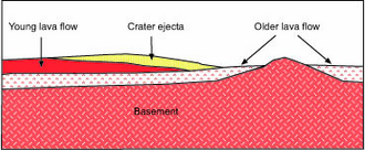
Schematic cross section of image at left. Surface units are interpreted as a sequence of layers (strata), with the youngest at top and oldest at bottom in accordance with the law of superposition.

例えば、暗い色の溶岩流が明るい色のクレーター地帯を覆っている場合、溶岩流の方が新しいと判断されます。さらにその上にクレーターの噴出物が乗っていれば、そのクレーターが最も新しい出来事であると分かります。
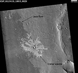
HiRISE image illustrating superpositioning, a principle that lets geologists determine the relative ages of surface units. The dark-toned lava flow overlies (is younger than) the light-toned, more heavily cratered terrain (older lava flow?) at right. The ejecta of the crater at center overlies both units, indicating that the crater is the youngest feature in the image. (See schematic cross section, right.)

時代区分と地球との比較

ノアキアンは、月における「前ネクタリウス期」から「初期インブリウス期」に相当します。この時期は太陽系全体で隕石の衝突頻度が急増した「後期重爆撃期」と重なっており、火星だけでなく月にも巨大な衝突盆地が数多く形成されました。

激動の環境:衝突・火山・そして水

絶え間ない隕石の猛攻

約40億年前の太陽系内部では、現在の500倍もの頻度で衝突が起きていたと考えられています。火星では100万年ごとに直径100km級のクレーターが1つ形成される計算になり、小規模な衝突はさらに頻繁でした。これらの衝撃は地殻を数キロメートルまで破砕し、放出された熱によって大気や地表が高温に加熱されました。また、この激しい衝突が初期の火星大気を宇宙空間へ剥ぎ取る要因になったという説もあります。

水による地形の形成

ノアキアン時代の最大の特徴は、液体の水が地表に存在した強力な証拠が数多く見つかることです。多くの古いクレーターは縁が削られ、内部に堆積物が溜まっており、これは後のヘスペリア時代よりも1,000倍から100,000倍も浸食速度が速かったことを示唆しています。

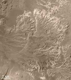
特に、樹枝状に広がる「谷ネットワーク」は、かつて地表を水が流れていた決定的な証拠とされています。また、エバースワルデ・クレーターに見られるようなデルタ地帯の形成は、湖や海のような安定した水域が存在した可能性を裏付けています。
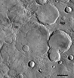
Geologic contact of Noachian and Hesperian Systems. Hesperian ridged plains (Hr) embay and overlie older Noachian cratered plains (Npl). Note that the ridged plains partially bury many of the old Noachian-aged craters. Image is THEMIS IR mosaic, based on similar Viking photo shown in Tanaka et al. (1992), Fig. 1a, p. 352.
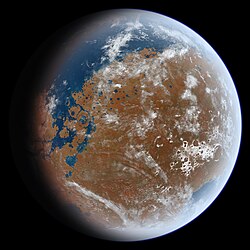
Artist's impression of an early wet Mars. Late Hesperian features (outflow channels) are shown, so this does not present an accurate picture of Noachian Mars, but the overall appearance of the planet from space may have been similar. In particular, note the presence of a large ocean in the northern hemisphere (upper left) and a sea covering Hellas Planitia (lower right).
Branched valley network of Warrego Valles (Thaumasia quadrangle), as seen by Viking Orbiter. Valley networks like this provide some of the strongest evidence that surface runoff occurred on early Mars.[50]
Delta in Eberswalde Crater, seen by Mars Global Surveyor.

タルシスの隆起と火山活動

この時代、火星のタルシス地域では猛烈な火山活動が展開されました。巨大なタルシス膨らみの大部分はこの時期に形成されたと考えられています。火山から放出された大量の二酸化炭素や水蒸気は、火星に厚い大気層(推定1.5バールのCO2大気)と、全地球を120mの深さで覆うほどの水を供給した可能性があります。

化学的証拠と鉱物の変質

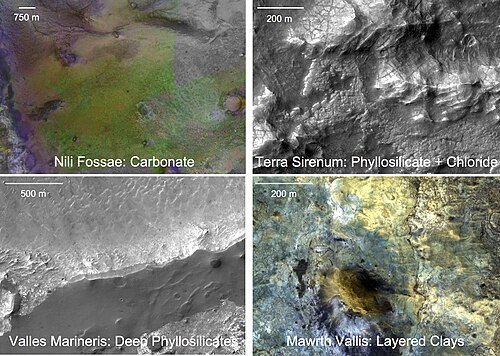
地表に残された鉱物の分析からも、水の存在が証明されています。ゲール・クレーターなどの堆積丘では、水との反応で形成されるフィロケイ酸塩(粘土鉱物)や硫酸塩の層が確認されています。また、下部ノアキアンの岩石からは、水による化学的な変質を受けたスペクトル特性が検出されており、当時の火星が化学的に活性な環境であったことを物語っています。
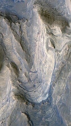
Layers of phyllosilicates and sulfates exposed in sediment mound within Gale Crater (HiRISE).
Four outcroppings of Lower Noachian rocks showing spectral signatures of mineral alteration by water. (CRISM and HiRISE images from the Mars Reconnaissance Orbiter)

ノアキアン時代の概要まとめ

ノアキアン時代の主要特性
項目 詳細 影響・結果
推定年代 41億年 〜 37億年前 太陽系初期の激動期に一致
主要イベント 後期重爆撃期 (LHB) 巨大盆地の形成、地殻の破砕
気候・環境 温暖で湿潤な可能性 谷ネットワーク、湖、海の形成
火山活動 タルシス地域の成長 大気成分の供給、温室効果
代表的な鉱物 フィロケイ酸塩、硫酸塩 液体の水による岩石の変質

Frequently Asked Questions

ノアキアン時代に海は存在したのでしょうか?

確定的な結論は出ていませんが、北半球の低地やヘラス盆地などの巨大な窪地に、広大な海や湖が存在したという説が有力視されています。デルタ地帯や谷ネットワークの分布がその根拠となっています。

なぜノアキアン時代のクレーターは摩耗しているのですか?

後の時代に比べて、水や大気による浸食作用が非常に強かったためです。液体の水が地表を流れたことで、クレーターの縁が削られ、内部に堆積物が溜まったと考えられています。

タルシスの火山活動は環境にどう影響しましたか?

大量の二酸化炭素や水蒸気を大気中に放出したことで、温室効果を高め、液体の水が安定して存在できる温暖な環境を作り出したと考えられています。

ノアキアン時代と地球の歴史はどう対応していますか?

地球の冥王代(Hadean)から太古zoic代(Archean)の初期に相当します。地球において最初の生命体が誕生したとされる時期とほぼ重なっています。

「地層累重の法則」とは火星の調査にどう役立つのですか?

「新しい地層は古い地層の上に積み重なる」という原則です。これにより、どのクレーターが先にでき、その後にどの溶岩流が覆ったかという相対的な時間軸を特定でき、火星の歴史を再構成することが可能になります。

References

  1. The size-distribution of Earth-crossing asteroids greater than 100 m in diameter follows an inverse power-law curve of form N = kD−2.5, where N is the number of asteroids larger than diameter D. Asteroids with smaller diameters are present in much greater numbers than asteroids with large diameters.

📸 フォトギャラリー

Schematic cross section of image at left. Surface units are interpreted as a sequence of layers (strata), with the youngest at top and oldest at bottom in accordance with the law of superposition.
HiRISE image illustrating superpositioning, a principle that lets geologists determine the relative ages of surface units. The dark-toned lava flow overlies (is younger than) the light-toned, more heavily cratered terrain (older lava flow?) at right. The ejecta of the crater at center overlies both units, indicating that the crater is the youngest feature in the image. (See schematic cross section, right.)
Geologic contact of Noachian and Hesperian Systems. Hesperian ridged plains (Hr) embay and overlie older Noachian cratered plains (Npl). Note that the ridged plains partially bury many of the old Noachian-aged craters. Image is THEMIS IR mosaic, based on similar Viking photo shown in Tanaka et al. (1992), Fig. 1a, p. 352.
Artist's impression of an early wet Mars. Late Hesperian features (outflow channels) are shown, so this does not present an accurate picture of Noachian Mars, but the overall appearance of the planet from space may have been similar. In particular, note the presence of a large ocean in the northern hemisphere (upper left) and a sea covering Hellas Planitia (lower right).
Branched valley network of Warrego Valles (Thaumasia quadrangle), as seen by Viking Orbiter. Valley networks like this provide some of the strongest evidence that surface runoff occurred on early Mars.[50]
Delta in Eberswalde Crater, seen by Mars Global Surveyor.
Layers of phyllosilicates and sulfates exposed in sediment mound within Gale Crater (HiRISE).
Four outcroppings of Lower Noachian rocks showing spectral signatures of mineral alteration by water. (CRISM and HiRISE images from the Mars Reconnaissance Orbiter)