To illustrate Mauna Kea's dry prominence, imagine raising the sea level of the Pacific Ocean to submerge the top of Mauna Kea. Then slowly lower it again. The first thing to appear is the peak of Mauna Kea. Then Mauna Loa and peaks of the surrounding Hawaiian Islands will emerge from the ocean. If the ocean drains further, the island around Mauna Kea will grow and merge with the adjacent islands. Continue draining until a land bridge forms between the Hawaiian Islands and a continent so that it is possible to walk all the way there without getting wet. Stop draining at this point, and this bridge is the key col of a dry Mauna Kea, connecting it to Mount Everest. Mauna Kea's peak stands 30,610 ft (9,330 m) above this key col.
← ホームへ戻る
マウナケアハワイ楯状火山天文台最高峰

マウナケア山の全貌ハワイの最高峰が持つ地質学的価値と天文学的重要性

🗓 2026年8月11日

太平洋に浮かぶハワイ諸島の中で、ひときわ高い存在感を放つのがマウナケア山です。海抜4,207メートルという標高を誇るこの山は、単なる地域の最高峰にとどまらず、地球規模での地質学的特異性と、宇宙の謎を解き明かす天文学の聖地としての二つの顔を持っています。

この山は、緩やかな傾斜を持つ「楯状火山(たてじょうかざん)」の一種であり、その巨大な質量は地球の地殻にまで影響を与えています。裾野は海底深くから広がっており、海底からの全高を考慮すれば、世界で最も高い山の一つと言えるでしょう。
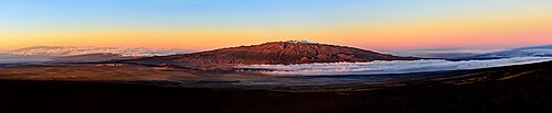
Mauna Kea, one of the volcanoes constituting the island of Hawai‘i, is an inactive shield volcano and one of the tallest mountains on Earth at an elevation of 13,786 feet.

Key Facts

  • 標高:海抜4,207メートル(ハワイ州最高峰)
  • 火山タイプ:現在は活動していない楯状火山
  • 地質学的特徴:巨大な体積により、下の海洋地殻を約6km押し下げている
  • 天文学的価値:世界有数の観測条件を備え、複数の国際的な天文台が設置されている
  • 生態系:高山砂漠地帯など、厳しい環境に適応した固有種が生息している

地質学的構造と地形的特異性

マウナケアは、ハワイ・エンペラー海山列の一部を構成する火山です。その体積は32,000立方キロメートルを超え、隣接するマウナロア山と共に、そのあまりの重さで海洋地殻を3.7マイル(約6km)も沈み込ませているという驚くべき事実があります。

Clickable imagemap of Hawaiʻi island showing the location of Mauna Kea, making up 22.8 percent of the island's surface area[4]

地質学的な時間軸で見ると、最古の岩石は約23万7,000年前のものと推定されており、山全体の形成には約100万年を要したと考えられています。最後の噴火は約紀元前2,460年頃に起こったとされており、現在は不活性な状態にあります。
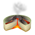
Scheme of a Hawaiian eruption

また、「地形的突出度(プロミネンス)」という観点から見ると、マウナケアは世界的に見ても非常に高い数値を示しています。もし太平洋の海面を上げて山頂だけを残し、そこから大陸まで繋がる最低地点(鞍部)を基準に高さを測れば、エベレストとの接続点から9,330メートルもの高さがある計算になります。
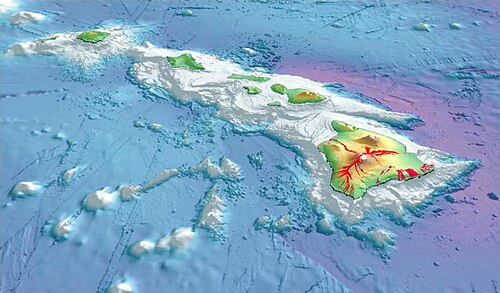
To illustrate Mauna Kea's dry prominence, imagine raising the sea level of the Pacific Ocean to submerge the top of Mauna Kea. Then slowly lower it again. The first thing to appear is the peak of Mauna Kea. Then Mauna Loa and peaks of the surrounding Hawaiian Islands will emerge from the ocean. If the ocean drains further, the island around Mauna Kea will grow and merge with the adjacent islands. Continue draining until a land bridge forms between the Hawaiian Islands and a continent so that it is possible to walk all the way there without getting wet. Stop draining at this point, and this bridge is the key col of a dry Mauna Kea, connecting it to Mount Everest. Mauna Kea's peak stands 30,610 ft (9,330 m) above this key col.

多様な生態系と厳しい自然環境

標高が高くなるにつれ、マウナケアの環境は劇的に変化します。低地から中腹にかけては、ママネ(Sophora chrysophylla)やナイオの森が広がり、さらに高所へ進むと、厳しい気候に適応した高山砂漠地帯へと移行します。
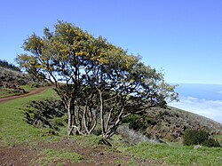
A pair of māmane (Sophora chrysophylla) trees

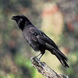
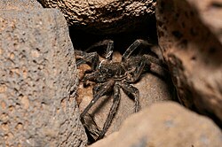
この過酷な環境下では、マウナケア・シルバーソードのような希少な固有植物や、未記載のコモリグモなどの特異な生物が生き残っています。また、野生では絶滅したとされるハワイカラス(ʻalalā)の再導入計画など、生物多様性の保全活動も行われています。
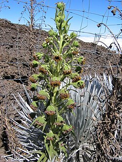
Mauna Kea silversword (Argyroxiphium sandwicense sandwicense) growing near the volcano's summit
Undescribed Lycosa wolf spider endemic to the summit alpine desert on Mauna Kea
The ʻalalā or Hawaiian crow (Corvus hawaiiensis) is a bird in the crow family. It is extinct in the wild, with plans to reintroduce the species into the Hakalau Forest National Wildlife Refuge.

気候面では、山頂付近は年間を通じて低温であり、冬には季節的な積雪が見られます。平均最高気温が10度を下回る月が多く、非常に厳しい気象条件にさらされています。

世界最高峰の天体観測拠点

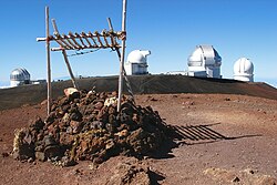
マウナケアの山頂は、空気が薄く乾燥しており、雲海の上に位置するため、地上で最も天体観測に適した場所の一つとされています。そのため、すばる望遠鏡やケック望遠鏡、ジェミニ北望遠鏡など、世界各国の最先端施設が集結しています。
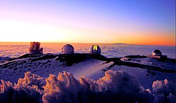
Sunset over four telescopes of the Maunakea Observatories. From left to right: the Subaru Telescope, the twin Keck I and II telescopes, and the NASA Infrared Telescope Facility.
Four observatories from the summit (left to right): United Kingdom Infrared Telescope, UH88, Gemini North, and the Canada–France–Hawaii Telescope

これらの施設は、宇宙の起源や遠方の銀河を研究するための重要な拠点となっています。一方で、この地は先住民ハワイアンにとって神聖な場所でもあり、科学的な開発と文化的価値の保存という難しいバランスの維持が求められています。
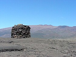
A stone structure or Ahu facing Mauna Kea, on Saddle Road between Mauna Kea and Mauna Loa

観光とレクリエーション

多くの人々がこの山を訪れます。サドルロード(Saddle Road)を経由して山頂へ向かうルートが一般的であり、そこからは隣接するマウナロア山や、遠くマウイ島のハレアカラ山まで見渡すことができます。
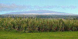
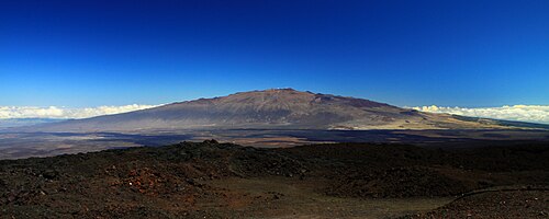
Mauna Kea from the Saddle Road near Hilo
View of the mountain from Mauna Loa Observatory
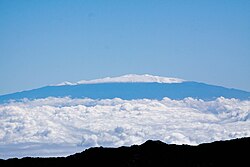
Mauna Kea from the summit of Haleakalā on Maui, approximately 78 mi (126 km) away

登山や星空観測などのアクティビティが人気ですが、急激な標高上昇による高山病のリスクがあるため、十分な注意が必要です。また、近隣のマウナロア山では現在も火山活動が続いており、クラウドカムなどの監視システムで常に状況がチェックされています。
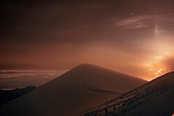
Lava flows from Mauna Loa caught by one of the International Gemini Observatory's Cloudcams, which operates 24/7 near the snow-covered summit of Maunakea (the highest point in the image).(on 27 November 2022).

歴史的には、1834年にこの山で亡くなったスコットランドの植物学者デビッド・ダグラスのように、自然科学への情熱を持ってこの地を訪れた先駆者たちの足跡が残っています。
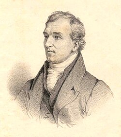
David Douglas, a Scottish botanist who died on Mauna Kea in 1834

マウナケアの基本データまとめ

以下に、マウナケア山の主要なデータをまとめました。

マウナケア山の主要諸元
項目 詳細内容
最高標高 4,207メートル (13,803フィート)
山種 不活性な楯状火山
推定形成期間 約100万年
最後の噴火 紀元前2,460年 ± 100年
主な植生 ママネ、シルバーソード(固有種)
主な施設 国際的な天文台群

Frequently Asked Questions

マウナケアは現在も噴火する可能性がありますか?

マウナケアは現在「不活性」な火山とされており、最後の噴火は約4,000年以上前です。そのため、隣接するマウナロアやキラウエアのような頻繁な活動は見られません。

なぜ山頂に多くの天文台があるのですか?

標高が高いため大気の影響を受けにくく、また乾燥した空気が広がっているため、星の光が歪みにくく、非常にクリアな観測が可能だからです。

登山する際に注意すべき点は何ですか?

最も注意すべきは高山病です。短時間で4,000メートル級の高さまで上昇するため、十分な水分補給と休息が必要です。また、山頂付近は極めて低温になるため、防寒装備が不可欠です。

マウナケアとエベレストはどちらが高いですか?

海抜(海面からの高さ)ではエベレストが世界最高峰ですが、海底からの全高を測定した場合、マウナケアはエベレストを凌ぐ高さを持つと言われています。

どのような固有種が住んでいますか?

シルバーソードという独特な形状の植物や、高山砂漠に適応したコモリグモなどが代表的です。これらは世界中でここだけにしか存在しない貴重な種です。

References

  1. Such as , , and the . Definitions of base vary and it is less clearly defined than the concept of prominence. This is discussed further in the section of this article.

📸 フォトギャラリー

To illustrate Mauna Kea's dry prominence, imagine raising the sea level of the Pacific Ocean to submerge the top of Mauna Kea. Then slowly lower it again. The first thing to appear is the peak of Mauna Kea. Then Mauna Loa and peaks of the surrounding Hawaiian Islands will emerge from the ocean. If the ocean drains further, the island around Mauna Kea will grow and merge with the adjacent islands. Continue draining until a land bridge forms between the Hawaiian Islands and a continent so that it is possible to walk all the way there without getting wet. Stop draining at this point, and this bridge is the key col of a dry Mauna Kea, connecting it to Mount Everest. Mauna Kea's peak stands 30,610 ft (9,330 m) above this key col.
Clickable imagemap of Hawaiʻi island showing the location of Mauna Kea, making up 22.8 percent of the island's surface area[4]
Lava flows from Mauna Loa caught by one of the International Gemini Observatory's Cloudcams, which operates 24/7 near the snow-covered summit of Maunakea (the highest point in the image).(on 27 November 2022).
A stone structure or Ahu facing Mauna Kea, on Saddle Road between Mauna Kea and Mauna Loa
View of the mountain from Mauna Loa Observatory
Mauna Kea, one of the volcanoes constituting the island of Hawai‘i, is an inactive shield volcano and one of the tallest mountains on Earth at an elevation of 13,786 feet.
David Douglas, a Scottish botanist who died on Mauna Kea in 1834
Mauna Kea silversword (Argyroxiphium sandwicense sandwicense) growing near the volcano's summit
Undescribed Lycosa wolf spider endemic to the summit alpine desert on Mauna Kea
A pair of māmane (Sophora chrysophylla) trees
The ʻalalā or Hawaiian crow (Corvus hawaiiensis) is a bird in the crow family. It is extinct in the wild, with plans to reintroduce the species into the Hakalau Forest National Wildlife Refuge.
Sunset over four telescopes of the Maunakea Observatories. From left to right: the Subaru Telescope, the twin Keck I and II telescopes, and the NASA Infrared Telescope Facility.
Mauna Kea from the summit of Haleakalā on Maui, approximately 78 mi (126 km) away
Mauna Kea from the Saddle Road near Hilo
Four observatories from the summit (left to right): United Kingdom Infrared Telescope, UH88, Gemini North, and the Canada–France–Hawaii Telescope
Scheme of a Hawaiian eruption