Global topography of Mars based on MOLA data. The Tharsis bulge is the large area at left (shown in shades of red and white). Amazonis and Chryse Planitiae are the blue areas left (west) and right (east) of Tharsis, respectively. In this image, the higher average elevation of the southern hemisphere (zonal spherical harmonic degree 1) has been removed to highlight the elevation contrast of Tharsis with the rest of the planet.
← ホームへ戻る

タルシス地域火星最大級の火山台地とその地質学的謎

🗓 2026年8月11日

火星の西半球に位置するタルシスは、惑星全体の地形を決定づけるほど巨大な火山台地です。赤道付近を中心に広がるこの地域は、太陽系で最大規模の火山群を擁しており、その圧倒的な質量と高度は火星の地質学的進化を解き明かす鍵となっています。

一般的に「タルシスの膨らみ(Tharsis bulge)」と呼ばれるこの広大な隆起帯は、地球の火山島列を形成するホットスポットに似たメカニズムによって形成されたと考えられています。
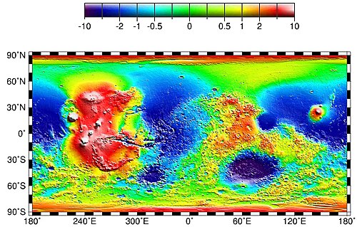
Global topography of Mars based on MOLA data. The Tharsis bulge is the large area at left (shown in shades of red and white). Amazonis and Chryse Planitiae are the blue areas left (west) and right (east) of Tharsis, respectively. In this image, the higher average elevation of the southern hemisphere (zonal spherical harmonic degree 1) has been removed to highlight the elevation contrast of Tharsis with the rest of the planet.

Key Facts

  • 規模: 直径約5,000kmに及び、火星表面の最大25%をカバーする。
  • 高度: 火山を除いた台地部分だけでも平均約7kmの高さがある。
  • 主要火山: 太陽系最大のオリンポス山と、タルシス三山(アルシア山、パボニス山、アスクライオス山)が存在する。
  • 質量: 準惑星ケレスに匹敵する約1022kgの質量を持つ。
  • 地質学的影響: その巨大な質量により、火星の自転軸に対する地殻の向きが変化した(真極移動)可能性がある。

タルシスの地理的構造と区分

タルシスは明確な境界線を持つ地域ではありませんが、大きく分けて南北の台地領域と、その間に位置する火山密集地帯に分類されます。

南部:タウマシア高原と高地

南部の広大な領域は、古いクレーターが点在する高地の上に形成されています。東側には幅約3,000kmに及ぶタウマシア高原が広がり、その西端には「サソリの尾」のような形状をした断層帯(クラリタス溝)や山脈が連なっています。この地域にはシリア平原やシナイ平原などの盆地が含まれ、タルシスの中でも特に標高が高い地点が集中しています。
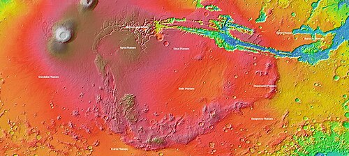
MOLA topography of the Thaumasia Plateau (Syria-Thaumasia block) and southern Tharsis. The volcano shown at the left is Arsia Mons. Valles Marineris extends across the northern edge. The areas in brown have the highest elevations on the Tharsis Plateau and may be considered the "summit region" of the Tharsis bulge.

中央部:タルシス三山と溶岩平原

地域の中心部には、アルシア山、パボニス山、アスクライオス山の3つの巨大な盾状火山(タルシス三山)が並んでいます。周囲には比較的新しい時代の溶岩流が広がっており、北西方向には幅200kmに達する巨大な谷が走っています。これらの谷は、かつて大規模な洪水が発生した際に形成されたと考えられています。
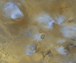
Orographic water ice clouds hover over the volcanic peaks of the central Tharsis region in this color image mosaic from Mars Global Surveyor. Olympus Mons dominates at upper left. At center are the three Tharsis Montes: Arsia Mons at bottom, Pavonis Mons at center, and Ascraeus Mons at top.

北西部:オリンポス山領域

メインの隆起帯から少し離れた位置に、太陽系最大の火山であるオリンポス山がそびえ立っています。この火山とその周囲の溶岩流は独立したサブプロビンスを形成しており、タルシスの火山活動の中でも比較的若い時代に形成されました。

地質学的特性と惑星への影響

大気形成への寄与

タルシスの形成は、火星の環境に劇的な変化をもたらしました。約37億年前のノアキス紀末までには台地の基礎が完成していたとされています。火山活動によって放出された大量の二酸化炭素や水蒸気は、かつての火星に厚い大気層と全球的な海洋を形成した主因であるという説があります。また、放出された硫黄や塩素が水と反応し、硫酸塩鉱物を生成させる化学風化を引き起こしたと考えられています。

真極移動(True Polar Wander)

タルシスの質量があまりに巨大であるため、火星の慣性モーメントに影響を与え、地殻ごと自転軸に対する位置がずれる「真極移動」が発生した可能性が指摘されています。ある研究では、タルシスはもともと北緯50度付近で形成され、その後赤道方向へ移動したとされており、これが惑星規模の激しい気候変動を招いたと推測されています。

単一の巨大火山説

近年の地質学的視点では、タルシス全体を「一つの巨大な火山」と捉える大胆な説が提唱されています。この説では、オリンポス山やタルシス三山は、巨大な火山体の上にできた寄生火山や山頂円錐丘に過ぎないとされます。マリネリス峡谷のような巨大な溝は、火山体の拡大に伴う裂け目(リフト)であると解釈されます。
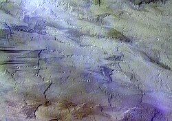
Images of ice water clouds over Tharsis taken by the ExoMars Trace Gas Orbiter, 2016

タルシス概要まとめ

タルシス地域の主要データ
項目 詳細
位置 火星西半球(赤道付近)
推定直径 約5,000 km
台地平均高度 約7 km(火山除く)
主要地形 オリンポス山、タルシス三山、マリネリス峡谷
形成時期 ノアキス紀末(約37億年前)から継続的に活動
推定質量 約1022 kg

Frequently Asked Questions

タルシスはなぜこれほど巨大になったのですか?

地球のようなプレートテクトニクスが存在せず、地殻が固定されていたため、一つのホットスポットから噴出した溶岩が数億年にわたって同じ場所に積み重なり続けたためと考えられています。

オリンポス山はタルシスの一部ですか?

はい。地形的な中心からは少し離れていますが、地質学的なプロセスはタルシスの火山活動と密接に関連しており、この地域のサブプロビンスとして分類されます。

タルシスの火山は現在も活動していますか?

大部分は古代の火山ですが、一部の溶岩流は地質学的に見て比較的最近(アマゾニアン期)のものとされており、非常に長い期間にわたって断続的に活動していたことが示唆されています。

真極移動とは具体的にどのような現象ですか?

惑星の内部質量分布が変化することで、自転軸に対する地殻全体の向きが変わる現象です。タルシスの巨大な質量が火星のバランスを崩し、地表の地形が北極方向から赤道方向へと「滑った」ような状態を指します。

マリネリス峡谷とタルシスの関係は?

マリネリス峡谷は、タルシスの隆起に伴う地殻の歪みや、火山活動による地表の引き裂き(リフティング)によって形成された巨大な断層系であると考えられています。

References

  1. Officially, "Tharsis" is an albedo feature.

📸 フォトギャラリー

Global topography of Mars based on MOLA data. The Tharsis bulge is the large area at left (shown in shades of red and white). Amazonis and Chryse Planitiae are the blue areas left (west) and right (east) of Tharsis, respectively. In this image, the higher average elevation of the southern hemisphere (zonal spherical harmonic degree 1) has been removed to highlight the elevation contrast of Tharsis with the rest of the planet.
MOLA topography of the Thaumasia Plateau (Syria-Thaumasia block) and southern Tharsis. The volcano shown at the left is Arsia Mons. Valles Marineris extends across the northern edge. The areas in brown have the highest elevations on the Tharsis Plateau and may be considered the "summit region" of the Tharsis bulge.
Orographic water ice clouds hover over the volcanic peaks of the central Tharsis region in this color image mosaic from Mars Global Surveyor. Olympus Mons dominates at upper left. At center are the three Tharsis Montes: Arsia Mons at bottom, Pavonis Mons at center, and Ascraeus Mons at top.
Images of ice water clouds over Tharsis taken by the ExoMars Trace Gas Orbiter, 2016