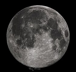
月の南端に位置する月南極は、現代の宇宙探査において最も注目を集める領域の一つです。この地域が科学者を惹きつけてやまない最大の理由は、太陽光が永遠に届かない「永久影」と呼ばれるエリアに、水氷などの揮発性物質が保存されている可能性が高いためです。これらの氷は、太陽系初期の歴史を刻んだ「化石記録」としての価値を持っており、宇宙の起源を解き明かす鍵を握っています。
北極地域と比較して、南極にはこのような遮蔽されたクレーターが多く存在しており、資源の宝庫として期待されています。
Key Facts
- 水氷の存在: 永久影にある「コールドトラップ」に水や氷、水酸基(OH)が蓄積している。
- 極端な地形: 地球上のどの山よりも高いエプシロンピーク(約9.05km)や、巨大な南極エイトケン盆地が存在する。
- 特殊な照明条件: クレーターの縁はほぼ常に日光に照らされる一方、内部は完全な暗闇という対照的な環境にある。
- 探査の先駆者: インドのチャンドラヤーン3号が、世界で初めて月南極付近へのソフトランディングに成功した。
- 豊富な資源: 酸素(重量比約45%)、鉄、シリコンなどの有用元素が豊富に含まれている。
地理的特徴と環境
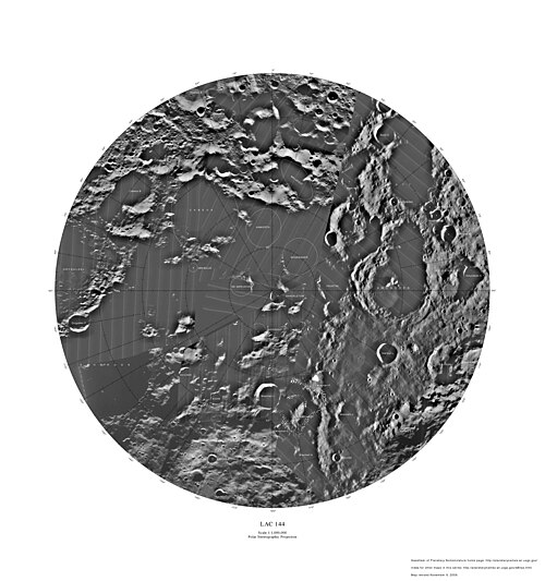
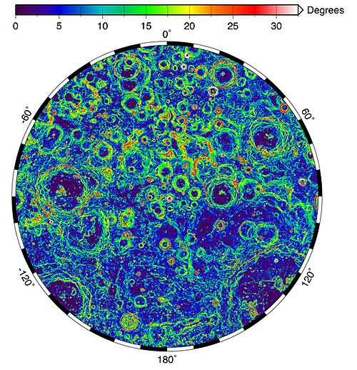
月南極は南緯80度から90度の南極圏に位置しています。数十億年前には現在の位置から約5.5度ずれており、この回転軸の変化によって、かつての影の領域に光が当たり、逆に新たな影が生まれるという変動を繰り返してきました。
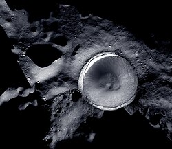
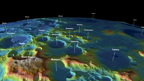
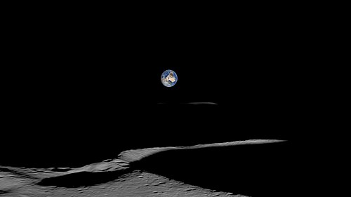
この地域の平均温度は約260K(マイナス13℃)ですが、地形によって環境は劇的に異なります。特にシャクルトンクレーターのような場所では、縁の部分はほぼ絶え間なく太陽光を浴びていますが、底の方は極低温のまま維持されています。
主要な地形とクレーター
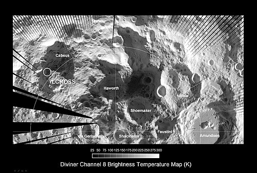
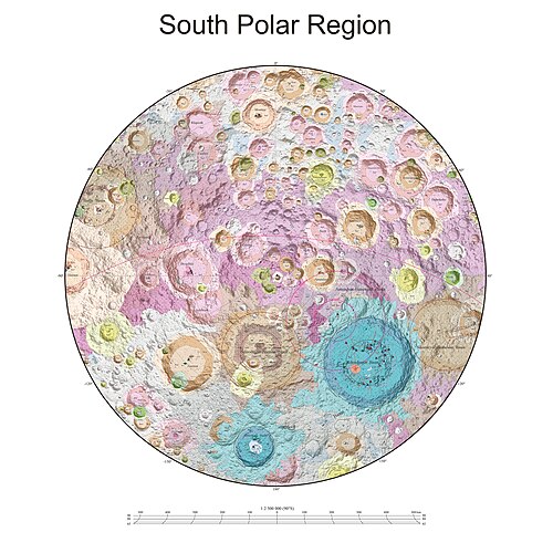
回転軸の中心点となるシャクルトンクレーターを中心に、デ・ゲルラッシュ、スベルドルプ、シューメーカー、ファウスティーニ、ハワース、ノビレ、カベウスといった重要なクレーターが点在しています。また、月全体の地質を理解する上で不可欠な南極エイトケン盆地もこの領域の象徴的な地形です。
コールドトラップと資源の科学
コールドトラップとは、熱的に極めて低温に保たれているため、一度入り込んだ揮発性物質が蒸発せずに留まる「罠」のような場所を指します。ここには彗星や隕石、あるいは太陽風による鉄還元プロセスによってもたらされた水や氷が蓄積しています。
これらの氷の保持は、散乱光や内部熱、地球からの照り返しといった熱物理学的特性によって制御されています。また、月表面から反射される中性水素原子の解析により、この地域の磁気ダイナミクスやプラズマの挙動についても研究が進んでいます。
月表面の化学組成
月南極付近には、将来の有人基地建設に不可欠な資源が豊富に存在します。特に酸素、鉄、シリコンが代表的であり、これらを現地で調達・加工することで、持続可能な探査が可能になります。
| 化合物 | 化学式 | 海(Maria) | 高地(Highlands) |
|---|---|---|---|
| シリカ | SiO2 | 45.4% | 45.5% |
| アルミナ | Al2O3 | 14.9% | 24.0% |
| 石灰 | CaO | 11.8% | 15.9% |
| 酸化鉄(II) | FeO | 14.1% | 5.9% |
| 酸化マグネシウム | MgO | 9.2% | 7.5% |
| 二酸化チタン | TiO2 | 3.9% | 0.6% |
| 酸化ナトリウム | Na2O | 0.6% | - |
月南極探査の歴史と最新ミッション
多くの国が月南極の解明に挑んできました。NASAのLRO(ルナー・リコネッサンス・オービター)は2009年から現在まで詳細なマッピングを続けており、Diviner放射計を用いて水氷の潜伏場所を特定しています。また、LCROSSミッションではカベウスクレーターに意図的に衝突させ、約5%の水が含まれていることを突き止めました。
近年の主要ミッション
- チャンドラヤーン1号 (ISRO): 月面への水存在を示唆し、MIP(ムーン・インパクト・プローブ)をシャクルトンクレーター縁に衝突させた。
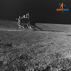
- チャンドラヤーン3号 (ISRO): 2023年8月、世界で初めて月南極付近へのソフトランディングに成功。
- ルナ25号 (ロシア): 2023年に打ち上げられたが、着陸直前に通信が途絶し失敗に終わった。
- IM-1 オデュッセウス (Intuitive Machines): 2024年2月、21世紀初の米国による月面着陸を実現。
- IM-2 (Intuitive Machines): 2025年3月に着陸したが、機体が横倒しになるトラブルに見舞われた。
未来の展望:月面拠点と天文学
月南極は、将来の有人基地(アウトポスト)の建設地として最適と考えられています。日光がほぼ常時当たる山頂部は太陽光発電に利用でき、一方で隣接する永久影からは水や鉱物を調達できるためです。NASAのアルテミス計画では、2020年代後半の有人着陸に向けて準備が進められています。
また、天文学的な利点もあります。地球からの電波干渉を受けないため、30MHz以下の低周波電波観測に理想的な環境です。中国のLongjiang-2などのミッションが、この可能性を切り拓いています。
今後の予定
- 嫦娥7号 (中国): 2026年、シャクルトンクレーターへの着陸と氷の探索を計画。
- Blue Moon Pathfinder (Blue Origin): 2026年、垂直着陸技術を用いた設備輸送を計画。
- アルテミス計画 (NASA): CLPS(商業月惑星輸送サービス)を通じたロボット探査の拡充と、その後の有人着陸。
Frequently Asked Questions
なぜ月南極に水があると考えられているのですか?
太陽光が全く届かない「永久影」と呼ばれるエリアがコールドトラップとして機能し、彗星や隕石などがもたらした水や揮発性物質が蒸発せずに氷の状態で保存されているためです。
チャンドラヤーン3号の功績は何ですか?
2023年8月、世界で初めて月南極付近という非常に困難な領域へのソフトランディング(緩やかな着陸)に成功し、現地での科学実験を可能にしたことです。
月南極に基地を作るメリットは何ですか?
生存に不可欠な水資源(氷)が確保できる可能性が高いことと、一部の山頂部でほぼ永続的に太陽光発電が行えるという、エネルギーと資源の両面で利点があるためです。
月南極でどのような天体観測ができるのですか?
地球からの電波ノイズに邪魔されないため、地球上では観測が不可能な30MHz以下の低周波電波を用いた宇宙観測を行うことができます。
IM-2ミッションで何が起きたのですか?
2025年3月に着陸しましたが、高度計の故障により正確な高度が把握できず、プラトー(台地)に衝突して機体が横倒しになったため、計画していた一部の実験に支障が出ました。
References
- "NASA Takes Aim at Moon with Double Sledgehammer". . 27 February 2008. Archived from the original on 15 July 2019. Retrieved 4 March 2010.
- Lunar South Pole. Archived 24 June 2017 at the NASA. 2017. Accessed on 16 July 2019.
- "South Pole Region of the Moon as Seen by Clementine". . 3 June 1996. Archived from the original on 27 July 2011. Retrieved 4 March 2010.
- "The Lunar Arctic Circle". xefer.com. Retrieved 16 May 2024.
- Wall, Mike (23 March 2016). "How the Moon Moved: Lunar Poles Have Wandered". Space.com. Retrieved 23 June 2024.
- Lunar South Pole Archived 18 April 2017 at the . (2017). Fossweb.com. Retrieved 29 March 2017.
- Spudis, P. D.; Stockstill, K. R.; Ockels, W. J.; Kruijff, M. (1995). "Physical Environment of the Lunar South Pole from Clementine Data: Implications for Future Exploration of the Moon". Abstracts of the Lunar and Planetary Science Conference. 26: 1339. :1995LPI....26.1339S.
- Gläser, P.; Scholten, F.; De Rosa, D.; Marco Figuera, R.; Oberst, J.; Mazarico, E.; Neumann, G. A.; Robinson, M. S. (2014). "Illumination conditions at the lunar south pole using high resolution Digital Terrain Models from LOLA". Icarus. 243: 78–90. :2014Icar..243...78G. :10.1016/j.icarus.2014.08.013.
- Vorburger, A. (2015). "Imaging the South Pole–Aitken basin in backscattered neutral hydrogen atoms." Planetary And Space Science, 115, 57–63.
- Wei, Guangfei; Li, Xiongyao; Wang, Shijie (2016). "Thermal behavior of regolith at cold traps on the Moon's south pole: Revealed by Chang'E-2 microwave radiometer data". Planetary and Space Science. 122: 101. :2016P&SS..122..101W. :10.1016/j.pss.2016.01.013.
📸 フォトギャラリー