私たちの目の前に広がる山々や深い谷、海岸線といった風景は、単なる静止した景色ではありません。これらは、地球の内部から湧き上がるエネルギーと、表面で絶えず作用する自然現象が複雑に絡み合って作り出された「動的な作品」です。地形学(Geomorphology)とは、こうした地表や海底の形態がどのようにして生まれ、時間とともにどう変化していくのかを科学的に解明する学問です。
地形学者は、フィールドワークによる観察、物理的な実験、そして高度な数値シミュレーションを組み合わせることで、現在の地形が形成された歴史を紐解き、将来どのような変化が起こるかを予測しようとしています。この分野は、地質学や物理地理学だけでなく、気候学、考古学、土木工学など、多岐にわたる専門領域と密接に連携しています。
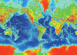
地球の表面は、赤道付近の熱帯雨林から極地の氷原まで、高度や環境によって多様な表情を見せています。
Key Facts
- 定義: 物理的、化学的、生物学的なプロセスによって形成される地表および海底の形態とその進化を研究する科学。
- 形成要因: 地殻変動(隆起・沈降)などの地質学的プロセスと、水・風・氷・生物による地表プロセスの相互作用で決定される。
- 学際的性質: 地理学、地質学、気候学、工学など、地球科学の多くの分野が交差する領域である。
- 現代の傾向: 記述的な観察から、数学的なモデルや直接的な測定に基づく定量的な分析へと進化している。
地形を決定づける2つの大きな力
地球の景観は、大きく分けて「地質学的プロセス」と「地表プロセス」という2つのメカニズムの交差点にあります。
1. 地質学的プロセス(内部からの力)
地球内部のエネルギーによる活動です。山脈を押し上げる隆起や、火山活動による地形の構築、地殻の沈降による堆積盆地の形成などが含まれます。また、地表の質量変化に応じて地殻が上下するアイソスタシー(地殻均衡)も重要な役割を果たします。
!["Cono de Arita" at the dry lake Salar de Arizaro on the Atacama Plateau, in northwestern Argentina. The cone itself is a volcanic edifice, representing complex interaction of intrusive igneous rocks with the surrounding salt.[10]](/images/01/9b/019b65fe1a46dc21b3e6eacc5812f37aad965ca0a38d24814e702de681eb9269.jpg)
2. 地表プロセス(外部からの力)
大気や水、生物が地表に働きかける作用です。雨水や河川による浸食、風による砂の運搬、氷河による削剥、さらには化学反応による岩石の風化や土壌の形成が含まれます。近年では、人間活動による地形改変も無視できない要因となっています。これらのプロセスは、その地域の気候に強く依存しています。
地形学の歴史的変遷
古代から近代までの洞察
地形への関心は古く、紀元前5世紀のヘロドトスは土壌の観察からナイルデルタの成長を指摘し、アリストテレスは陸地と海洋が周期的に入れ替わるという大胆な仮説を立てました。中国の宋代の科学者、沈括(しんかつ)は、山頂付近で貝殻の化石を発見したことから、かつてそこが海岸線であったことを見抜き、浸食と堆積による地形変化を論じました。
理論モデルの対立と進化
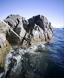
19世紀後半になると、ウィリアム・モリス・デイビスが「浸食サイクル」というモデルを提唱しました。これは、地殻が隆起した後、河川などの浸食によって徐々に平坦化していくという定性的な理論です。これに対し、ヴァルター・ペンクは、隆起と浸食が同時に進行し、互いに影響し合うという動的なモデルを提示し、議論を深めました。
![Part of the Great Escarpment in the Drakensberg, southern Africa. This landscape, with its high altitude plateau being incised into by the steep slopes of the escarpment, was cited by Davis as a classic example of his cycle of erosion.[33]](/images/31/16/3116892f3faa30faade41b9ec7cf9d3c054399c3bd85c1901567c269decda535.jpg)
気候の影響と定量化への移行
20世紀半ばには、気候が地形分布を決定づけるという「気候地形学」が台頭しました。しかし、その後、物理法則は地球上のどこでも共通であるという視点から、より厳密な数値測定と物理モデルを用いる「定量的地形学」へとシフトしました。これにより、地形の挙動を数学的に予測することが可能になりました。
![Badlands incised into shale at the foot of the North Caineville Plateau, Utah, within the pass carved by the Fremont River and known as the Blue Gate. G. K. Gilbert studied the landscapes of this area in great detail, forming the observational foundation for many of his studies on geomorphology.[1]](/images/ef/0e/ef0ebf5f57befe1043e3d90fc9ccf0487d753f774b5ed15d96d4371a9737d2e4.jpg)
多様な地形形成プロセスと事例
地形学では、作用する媒体ごとに以下のようなプロセスを研究します。
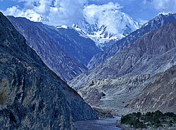
- 河川プロセス(Fluvial): 水の流れが岩盤を削り、深い峡谷を作ります。世界で最も深い河川峡谷であるインダス川の峡谷はその典型です。
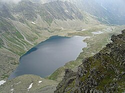
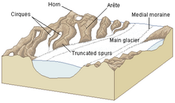
- 氷河プロセス(Glacial): 巨大な氷の塊が地表を削り取り、U字谷や氷河湖を形成します。
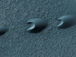
- 風成プロセス(Aeolian): 風が砂を運び、砂丘を形成します。これは地球上だけでなく、火星のような他惑星でも見られる現象です。
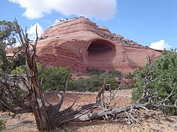
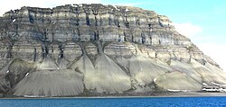
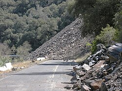
- 斜面プロセス(Hillslope): 重力によって岩石や土砂が崩落し、崖の下に崖錐(がいすい)と呼ばれる堆積地形を作ります。
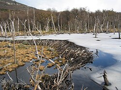
- 生物プロセス(Biological): ビーバーがダムを作るように、生物が地形を改変することを生物地形学と呼びます。
地形学の概要まとめ
地形学が扱う主要な要素を以下の表にまとめます。
| プロセス分類 | 主な駆動要因 | 代表的な地形・現象 |
|---|---|---|
| 地質学的 | プレートテクトニクス、マグマ | 山脈の隆起、火山、地溝帯 |
| 水文学的 | 河川、降雨、地下水 | V字谷、デルタ、峡谷 |
| 氷河学的 | 氷の移動、凍結融解 | 氷河湖、モレーン、フィヨルド |
| 風成学的 | 風による運搬・堆積 | 砂丘、ヤルダン |
| 生物学的 | 動物・植物の活動 | ビーバーダム、サンゴ礁 |
Frequently Asked Questions
地形学と地質学はどう違うのですか?
地質学が主に地球の構成物質(岩石や鉱物)やその内部構造、時間的な層序を扱うのに対し、地形学はそれらが地表に現れたときの「形(形態)」と、それがどう変化するかという「プロセス」に焦点を当てます。
気候が変わると地形はどう変わりますか?
気候は浸食の速度や種類を決定します。例えば、温暖湿潤な地域では化学的風化が進み土壌が厚くなりますが、寒冷地では凍結と融解の繰り返しによる物理的な破砕が支配的になります。また、氷河期になれば氷河による大規模な削剥が起こります。
人間は地形にどのような影響を与えていますか?
ダムの建設、大規模な採鉱、都市開発による土地造成などは、自然な地形変化の速度を遥かに上回るペースで地表を改変しています。これは現代の地形学において重要な研究対象となっています。
地形学の知識は実生活にどう役立ちますか?
地滑りや土砂崩れなどの自然災害の危険箇所を予測する防災計画や、道路・ダムなどのインフラ建設における地盤評価(工学的地質学)など、安全な社会基盤を築くために不可欠な知識です。
References
- Gilbert, Grove Karl, and Charles Butler Hunt, eds. Geology of the Henry Mountains, Utah, as recorded in the notebooks of GK Gilbert, 1875–76. Vol. 167. Geological Society of America, 1988.
- Huggett, Richard John (2011). "What Is Geomorphology?". Fundamentals Of Geomorphology. Routledge Fundamentals of Physical Geography Series (3rd ed.). . p. 3. .
- Willett, Sean D.; Brandon, Mark T. (January 2002). "On steady states in mountain belts". Geology. 30 (2): 175–178. :2002Geo....30..175W. :10.1130/0091-7613(2002)030<0175:OSSIMB>2.0.CO;2. 8571776.
- Roe, Gerard H.; Whipple, Kelin X.; Fletcher, Jennifer K. (September 2008). "Feedbacks among climate, erosion, and tectonics in a critical wedge orogen" (PDF). American Journal of Science. 308 (7): 815–842. :2008AmJS..308..815R. 10.1.1.598.4768. :10.2475/07.2008.01. 13802645.
{{}}: Cite uses deprecated parameter|citeseerx=() - Summerfield, M.A. (1991). Global Geomorphology. . p. 537. .
- Dunai, T.J. (2010). Cosmogenic Nucleides. . p. 187. .
- Messina, Paul (2 May 1997). "What is Digital Terrain Analysis?". Department of Geography, New York.
- Hargitai, Henrik; Kereszturi, Ákos, eds. (2015). Encyclopedia of Planetary Landforms. New York, NY: Springer New York. :10.1007/978-1-4614-3134-3. . 132406061.
- "International Conference of Geomorphology". Europa Organization. Archived from the original on 2013-03-17.
- Patowary, Kaushik (16 July 2014). "Cono de Arita in Argentina". amusingplanet.com.
📸 フォトギャラリー