熱帯太平洋における風の変化と海面水温の変動によって引き起こされるエルニーニョ・南方振動(ENSO)は、世界中の気象パターンを左右する巨大な気候現象です。この現象は不規則な周期で発生しますが、大気と海洋が密接に連動して起こるため、熱帯地方のみならず、高緯度地域にまで影響を及ぼす「テレコネクション(遠隔相関)」を持つことが特徴です。
ENSOは、海面水温が上昇する「エルニーニョ」相と、逆に低下する「ラニーニャ」相、そしてその中間の「中立」相の3つの状態で構成されています。これらの変動は通常2年から7年ごとに発生し、それぞれ1年程度の期間持続します。
Key Facts
- ENSOの正体:太平洋の海面水温変動(エルニーニョ/ラニーニャ)と大気の気圧変動(南方振動)が組み合わさった現象。
- 発生周期:不規則だが、一般的に2〜7年おきに発生する。
- エルニーニョ:東太平洋の海面水温が上昇し、インドネシアやオーストラリア付近で気圧が高くなる状態。
- ラニーニャ:東太平洋の海面水温が低下し、中・東太平洋で気圧が高くなる状態。
- 地球への影響:熱帯サイクロンの活動変化、深刻な干ばつや洪水など、世界的な異常気象を誘発する。
ENSOを駆動する科学的メカニズム
ビヤークネス・フィードバックとウォーカー循環
ENSOの核心にあるのは、大気と海洋が互いに影響を強め合う「ビヤークネス・フィードバック」という正のフィードバック機構です。通常、太平洋では東から西へ吹く貿易風が暖かい海水を西側に蓄積させます。これにより、西太平洋では対流が活発になり、低気圧と降雨が発生します。この東から西への大気の循環をウォーカー循環と呼びます。
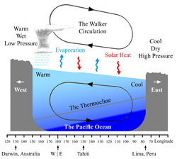
しかし、何らかの理由で貿易風が弱まると、西側に溜まっていた暖水が東へ流れ出し、赤道付近の湧昇(深海から冷たい水が上がってくる現象)が抑制されます。これがエルニーニョの始まりであり、水温上昇がさらに貿易風を弱めるという連鎖反応が起こります。最終的に西太平洋の暖水が減少すると、システムは再び正常な状態へと戻ります。
南方振動(Southern Oscillation)
海面水温の変化に呼応して起こる大気の気圧変動が「南方振動」です。これは太平洋の東側と西側で表面気圧が交互に変動する現象を指し、海面水温の変動とセットで機能しています。
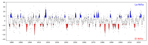
海面水温の3つのフェーズ
エルニーニョ相(温暖期)
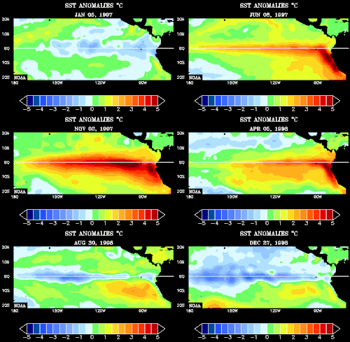
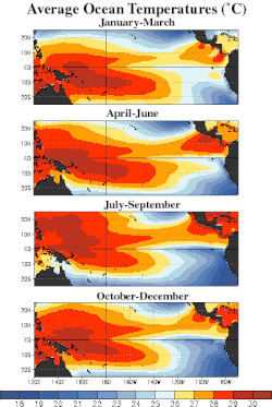
東太平洋の海面水温が平年より高くなる状態です。この時期、インドネシアやオーストラリア、インド洋から大西洋にかけて気圧が高くなる傾向にあります。過去には1997-98年などの極めて強力なイベントが記録されています。
ラニーニャ相(寒冷期)
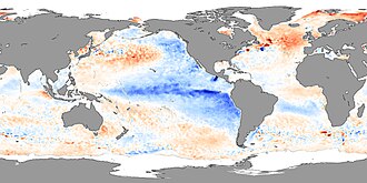
エルニーニョとは逆に、中・東太平洋の海面水温が平年より低下します。このとき、中・東太平洋で気圧が高まり、その他の熱帯・亜熱帯地域では気圧が低くなる傾向があります。ラニーニャはエルニーニョよりも持続期間が長く、繰り返し発生することがあります。
中立相
海面水温や気圧の変動が小さく、極端な傾向が見られない安定した状態を指します。
モニタリングと変動のパターン
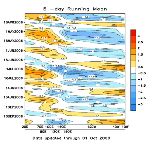
科学者は太平洋の特定の海域(Niño 1から4などの領域)の海面水温を継続的に監視することで、現在のENSOフェーズを判定しています。
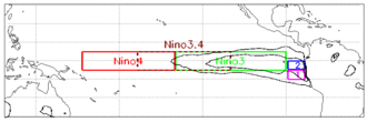
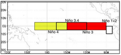
また、標準的なENSO以外にも、変動の中心地が異なる「ENSOモドキ」や、沿岸域で発生する「ENSOコステロ」といったバリエーションが存在することが分かっています。
地球環境と人間社会への影響
気象パターンと自然災害への影響
ENSOは世界的な気象変動を引き起こします。特に熱帯サイクロンの活動に大きな影響を与え、エルニーニョとラニーニャでは発生地域や頻度が異なります。
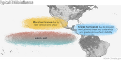
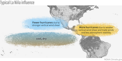
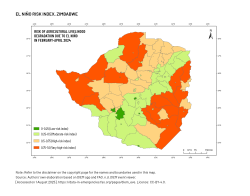
地域別の影響としては、アフリカでの深刻な干ばつや、オーストラリア・南米での豪雨などが挙げられます。例えば、2011年の東アフリカの干ばつでは、5万人から10万人が死亡したと報告されています。
![Between 50,000 and 100,000 people died during the 2011 East Africa drought.[166]](/images/21/8a/218a0ddb5b1dc660a93b25f78b8d3d45fd352b9e1bab1aaf63787b7077427855.jpg)
生態系と経済への打撃
海洋生態系への影響は甚大です。エルニーニョによる水温上昇は、プランクトンの濃度を変化させ、魚類の分布や量に影響を与えます。また、サンゴの白化現象を引き起こす主要な要因の一つとなります。
![El Niño has the most direct impact on life in the equatorial Pacific. Its effects propagate north and south along the coast of the Americas, affecting marine life around the Pacific. Changes in chlorophyll-a concentrations are visible in this animation, which compares phytoplankton in January and July 1998. Since then, scientists have improved both the collection and presentation of chlorophyll data.[clarification needed]](/images/3d/be/3dbeb34276b768bbcba9eb13967e64c933ba471d70eb13846f32c3006e2214d6.gif)
これらの環境変化は、漁業の不振や農業被害を通じて、地域経済に深刻な打撃を与えます。
気候変動と長期的な視点
IPCC(気候変動に関する政府間パネル)の第6次評価報告書では、将来的なENSOの挙動について研究が進められています。また、ENSOが気候システムの「ティッピング・ポイント(臨界点)」、つまりある閾値を超えると不可逆的な変化が起こる要素であるかどうかも議論の対象となっています。
![Earlier (2008) list of tipping elements in the climate system.[133] When compared to later lists, the major differences are that in 2008 ENSO, Indian summer monsoon, Arctic ozone hole and all of Arctic sea ice were all listed as tipping points. Labrador-Irminger circulation, mountain glaciers and East Antarctic ice however were not included. This 2008 list also includes Antarctic bottom water (part of the Southern Ocean overturning circulation), which was left out of the 2022 list, but included in some subsequent ones.](/images/72/76/727672e2298402cf6f298b04eb72f5f66e869c75baf4b638961c57330bb5f563.webp)
地質学的時間スケールでの記録
ENSOのような変動は、人類の歴史よりも遥か昔から存在していました。サンゴのコアや堆積物の分析により、数百万年前のマイオセン期やプリオセン期にも同様の変動があったことが示唆されています。
関連する気候振動
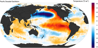
ENSO以外にも、太平洋十年規模振動(PDO)やマッデン・ジュリアン振動(MJO)、太平洋子午線モード(PMM)など、異なる時間・空間スケールの変動が相互に影響し合っています。
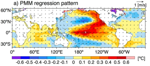
ENSOの概要まとめ
| 項目 | エルニーニョ (El Niño) | ラニーニャ (La Niña) |
|---|---|---|
| 東太平洋の水温 | 上昇(温暖) | 低下(寒冷) |
| 貿易風 | 弱まる | 強まる |
| 西太平洋の気圧 | 高くなる傾向 | 低くなる傾向 |
| 主な影響 | 東太平洋の豪雨、西太平洋の干ばつ | 東太平洋の干ばつ、西太平洋の豪雨 |
| 持続期間 | 約1年(強烈な場合がある) | 約1年(長期化・反復しやすい) |
Frequently Asked Questions
エルニーニョとラニーニャの最大の違いは何ですか?
最大の違いは太平洋赤道域の海面水温の変動方向です。エルニーニョは水温が平年より高くなる「温暖化」現象であり、ラニーニャは水温が平年より低くなる「寒冷化」現象です。これに伴い、大気の気圧配置と風の流れが逆転します。
なぜENSOが世界中の天気に影響を与えるのですか?
太平洋は地球上で最大の海洋であり、そこでの熱エネルギーの分布が変わると、大気の循環(ウォーカー循環など)が大きく変化します。この大気の変動が波のように地球全体に伝わる「テレコネクション」という仕組みにより、遠く離れた地域でも降水量や気温に影響が出ます。
ENSOの発生を正確に予測することは可能ですか?
完全な予測は困難です。発生パターンは不規則であり、大気と海洋の複雑な相互作用(ビヤークネス・フィードバックなど)が関わっているためです。しかし、海面水温のモニタリングや数値モデルを用いることで、数ヶ月先の傾向を予測する取り組みが行われています。
地球温暖化はエルニーニョに影響しますか?
はい。近年の研究やIPCCの報告では、気候変動がENSOの強度や頻度に影響を与える可能性が指摘されています。特に、より強力なエルニーニョ現象が発生しやすくなる可能性などが議論されています。
References
- Wald, Lucien (2021). "Definitions of time: from year to second". Fundamentals of solar radiation. Boca Raton: CRC Press. .
- (2005-12-19). "Frequently Asked Questions about El Niño and La Niña". . Archived from the original on 2009-08-27. Retrieved 2009-07-17.
- Trenberth, K.E.; P.D. Jones; P. Ambenje; R. Bojariu; D. Easterling; A. Klein Tank; D. Parker; F. Rahimzadeh; J.A. Renwick; M. Rusticucci; B. Soden; P. Zhai. "Observations: Surface and Atmospheric Climate Change". In Solomon, S.; D. Qin; M. Manning; et al. (eds.). Climate Change 2007: The Physical Science Basis. Contribution of Working Group I to the Fourth Assessment Report of the Intergovernmental Panel on Climate Change. Cambridge, UK: Cambridge University Press. pp. 235–336. Archived from the original on 2017-09-24. Retrieved 2014-06-30.
- "El Niño, La Niña and the Southern Oscillation". MetOffice. Archived from the original on 2023-10-27. Retrieved 2015-08-18.
- Becker, Emily (4 December 2014). "December's ENSO Update: Close, but no cigar". ENSO Blog. Archived from the original on 22 March 2016.
- "El Niño and La Niña". New Zealand's National Institute of Water and Atmospheric Research. 27 February 2007. Archived from the original on 19 March 2016. Retrieved 11 April 2016.
- Becker, Emily (2016). "How Much Do El Niño and La Niña Affect Our Weather? This fickle and influential climate pattern often gets blamed for extreme weather. A closer look at the most recent cycle shows that the truth is more subtle". Scientific American. 315 (4): 68–75. :10.1038/scientificamerican1016-68. 27798565.
- Brown, Patrick T.; Li, Wenhong; (27 January 2015). "Regions of significant influence on unforced global mean surface air temperature variability in climate models: Origin of global temperature variability". Journal of Geophysical Research: Atmospheres. 120 (2): 480–494. :10.1002/2014JD022576. :10161/9564.
- Trenberth, Kevin E.; Fasullo, John T. (December 2013). "An apparent hiatus in global warming?". Earth's Future. 1 (1): 19–32. :2013EaFut...1...19T. :10.1002/2013EF000165.
- IPCC, 2021: Climate Change 2021: The Physical Science Basis Archived 2023-12-08 at the . Contribution of Working Group I to the Sixth Assessment Report of the Intergovernmental Panel on Climate Change Archived 2023-05-26 at the [Masson-Delmotte, V., P. Zhai, A. Pirani, S.L. Connors, C. Péan, S. Berger, N. Caud, Y. Chen, L. Goldfarb, M.I. Gomis, M. Huang, K. Leitzell, E. Lonnoy, J.B.R. Matthews, T.K. Maycock, T. Waterfield, O. Yelekçi, R. Yu, and B. Zhou (eds.)]. Cambridge University Press, Cambridge, United Kingdom and New York, NY, USA, 2391 pp. doi:10.1017/9781009157896.
📸 フォトギャラリー