空を見上げると、時に巨大な渦を巻く雲が地球を覆うことがあります。これらは総称してサイクロンと呼ばれます。この言葉は古代ギリシャ語で「円」や「輪」を意味する「kýklos」に由来しており、風が螺旋状に回転する性質を表しています。19世紀半ばにヘンリー・ピディントンによって提唱されたこの用語は、現在では規模や発生場所、エネルギー源の異なる多様な低気圧システムを指す言葉として定着しています。
Key Facts
- サイクロンは、その特性によって「温帯」「亜熱帯」「熱帯」の3つの主要な地表ベースのタイプに分類される。
- 熱帯サイクロンは暖かい海水からエネルギーを得て発達し、陸地に上がると急速に弱まる。
- 極低気圧(ポーラーロー)は冬の寒冷な海域で発生し、船舶や海洋プラットフォームに危険を及ぼす。
- メソサイクロンや塵旋風(ダストデビル)のような、より小規模な非共鳴的渦も存在する。
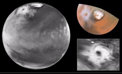
- 地球以外では、火星などの惑星でもサイクロン現象が観測されている。
地表付近で発生するサイクロンの分類
地表付近で活動するサイクロンは、温度勾配やエネルギーの得方によって大きく3つのカテゴリーに分けられます。
温帯低気圧(Extratropical Cyclone)
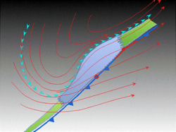
温帯低気圧は、熱帯のような特性を持たない大規模な低気圧システムです。これは「傾圧帯」と呼ばれる、温度や露点に水平方向の勾配がある領域に関連して発生します。前線(温暖前線や寒冷前線)を伴うのが大きな特徴です。
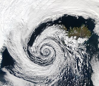
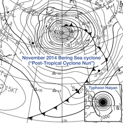
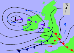
亜熱帯低気圧(Subtropical Cyclone)
亜熱帯低気圧は、温帯低気圧と熱帯サイクロンの両方の性質を併せ持つハイブリッドなシステムです。赤道から北緯・南緯50度の間で発生し、熱帯サイクロンよりも広い風域を持ち、最大風速の中心が中心から離れている傾向があります。形成に必要な海面温度は約23℃であり、これは熱帯サイクロンに必要な温度より3℃低いため、通常のハリケーンシーズン外でも発生することがあります。
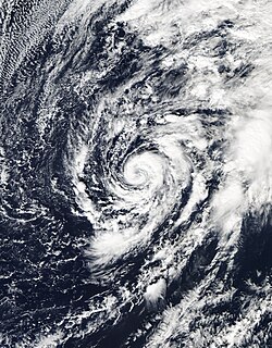
熱帯サイクロン(Tropical Cyclone)
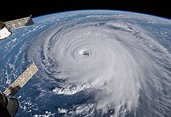
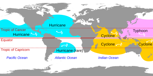
熱帯サイクロンは、暖かい海上で上昇気流による水蒸気の凝結から放出されるエネルギーによって駆動されます。この正のフィードバックループにより、猛烈な風と豪雨をもたらします。中心気圧の低下と強風によって海面が押し上げられる「高潮(ストームサージ)」が発生し、海岸線から最大40kmまで浸水被害を及ぼすことがあります。一方で、これらは熱帯の過剰なエネルギーを中緯度地域へ運ぶことで、地球全体の気温バランスを維持する重要な役割を担っています。
![Tropical cyclones form when the energy released by the condensation of moisture in rising air causes a positive feedback loop over warm ocean waters.[21]](/images/e0/8c/e08c5ed809547c017e2d56f34cafd1473f144c8fbd08b22525892d5a659292ab.webp)
極地および上層の特殊な低気圧
極低気圧(Polar Low)
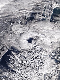
冬の寒冷な海域で、対流圏中層の温度がマイナス45℃に達するような寒冷核低気圧が通過すると、深い対流が発生し「極低気圧」が形成されます。規模は1,000km未満と小さく、寿命も数日と短いですが、地表付近で秒速17m以上の強風を伴う激しいシステムとなることがあります。従来の気象報告では検知が難しく、高緯度での航海や資源採掘プラットフォームにとって大きな脅威となります。
極渦(Polar Vortex / Polar Cyclone)
極渦は、冬に強まり夏に弱まる巨大な低気圧領域です。直径1,000kmから2,000kmに及び、北半球では反時計回りに、南半球では時計回りに回転します。これは熱帯サイクロンのような対流や、温帯低気圧のような温度差ではなく、地球規模の「極セル」による空気の流れによって形成される上層のシステムです。この渦が弱まると、寒気が中緯度へ流出し、激しい寒波の原因となります。
TUTTセル(TUTT Cell)
北半球の夏季、海洋上にある「熱帯上層対流圏トラフ(TUTT)」の底部から切り離された冷たい低気圧をTUTTセルと呼びます。高度6,100m以上に位置する上層の渦であり、ゆっくりと東北東から西南西へ移動します。稀に暖核の熱帯サイクロンへと発展することがあります。
小規模な渦と非共鳴的サイクロン
大規模な気象システム以外にも、局所的に発生する渦が存在します。
メソサイクロン(Mesocyclone)
スーパーセルと呼ばれる激しい雷雨の中で発生する、直径2kmから10kmの回転気流です。垂直軸を中心に回転し、強い上昇気流を伴うため、ここから竜巻が発生することがあります。米国では年間約1,700個発生しますが、その約半分だけが竜巻へと発展します。
塵旋風(Dust Devil)
晴れた日の暖かい地表で発生する小規模な渦です。砂漠などでよく見られ、周囲の空気が不安定な時に形成されます。多くは数分で消滅しますが、強いものは時速121kmに達し、小さな構造物を破壊することもあります。この現象は地球だけでなく、火星でも観測されています。
![Wind damage varies exponentially with wind speed, so that small increases in wind strength can dramatically increase damage.[49] Damages rise by about a factor of four for every category increase in the Saffir–Simpson scale.[49]](/images/38/80/3880452c07da8fc11f7389b724ceb7e0e78a90fd73fe7979eaf4ef8dea79ad5e.webp)
サイクロンの特性まとめ
| 種類 | 主なエネルギー源・要因 | 発生場所・環境 | 主な特徴 |
|---|---|---|---|
| 温帯低気圧 | 水平方向の温度・露点勾配 | 中・高緯度地域 | 前線を伴う大規模なシステム |
| 亜熱帯低気圧 | 温帯と熱帯の混合特性 | 赤道〜北緯/南緯50度 | 海面温度約23℃で発生、風域が広い |
| 熱帯サイクロン | 暖かい海上の水蒸気凝結熱 | 熱帯の暖かい海域 | 猛烈な風、豪雨、高潮を伴う |
| 極低気圧 | 寒冷海域での深い対流 | 極地付近の開いた海域 | 小規模で短寿命、検知が困難 |
| 極渦 | 地球規模の極セル循環 | 北極・南極上空 | 上層の巨大な低気圧、寒波に影響 |
| メソサイクロン | 対流性嵐(スーパーセル)内 | 局所的な雷雨域 | 竜巻の発生源となる回転気流 |
Frequently Asked Questions
熱帯サイクロンと温帯低気圧の決定的な違いは何ですか?
最大の違いはエネルギー源と構造です。熱帯サイクロンは暖かい海上の水蒸気が凝結する際に放出される潜熱をエネルギーとし、中心に暖かい空気を持つ「暖核」構造をしています。一方、温帯低気圧は異なる温度の空気の塊がぶつかり合う「温度勾配(傾圧性)」をエネルギーとし、前線を伴うのが特徴です。
亜熱帯低気圧はなぜ熱帯サイクロンより低い温度で発生できるのですか?
亜熱帯低気圧はもともと温帯低気圧から発展することが多く、上空に通常よりも冷たい空気を持っているため、海面温度が23℃程度であっても、海面と上空の温度差によって上昇気流が発生し、システムを維持できるためです。
極低気圧(ポーラーロー)が危険視される理由は何ですか?
規模が小さく、従来の気象観測網では捉えにくい「メソスケール」の現象であるためです。予報が困難なまま急激に発達し、強風と激しい降水をもたらすため、北極圏などの高緯度で活動する船舶や石油・ガスプラットフォームにとって非常に危険な存在となります。
塵旋風(ダストデビル)と竜巻は同じものですか?
いいえ、異なります。竜巻は通常、スーパーセルなどの巨大な積乱雲に伴うメソサイクロンから発生しますが、塵旋風は雲のない晴天時の地表加熱によって発生します。また、塵旋風は竜巻よりもはるかに小規模で、多くの場合、実害はありません。
地球以外の惑星でもサイクロンは発生しますか?
はい。例えば火星では、ハッブル宇宙望遠鏡によって北極付近に巨大なサイクロンが観測されています。大気を持つ惑星であれば、温度差や回転などの条件が揃えば、地球と同様の渦巻き現象が発生することがあります。
References
- Glossary of Meteorology (June 2000). "Cyclonic circulation". . Archived from the original on 2018-12-25. Retrieved 2008-09-17.
- Glossary of Meteorology (June 2000). "Cyclone". . Archived from the original on 2018-12-25. Retrieved 2008-09-17.
- BBC Weather Glossary (July 2006). "Cyclone". . Archived from the original on 2006-08-29. Retrieved 2006-10-24.
- "UCAR Glossary — Cyclone". University Corporation for Atmospheric Research. Archived from the original on 2018-12-25. Retrieved 2006-10-24.
- David Brand (1999-05-19). "Colossal cyclone swirling near Martian north pole is observed by Cornell-led team on Hubble telescope". . Archived from the original on June 13, 2007. Retrieved 2008-06-15.
- Samantha Harvey (2006-10-02). "Historic Hurricanes". . Archived from the original on 2008-04-15. Retrieved 2008-06-14.
- Nina A. Zaitseva (2006). "Cyclogenesis". . Archived from the original on 2006-08-30. Retrieved 2006-12-04.
- "Tropical cyclogenesis". www-das.uwyo.edu. Archived from the original on 17 May 2021. Retrieved 12 January 2021.
- Stan Goldenberg (2004-08-13). "Frequently Asked Questions: What is an extra-tropical cyclone?". , Hurricane Research Division. Archived from the original on 2007-02-09. Retrieved 2007-03-23.
- Evans, Clark; Wood, Kimberly M.; Aberson, Sim D.; Archambault, Heather M.; Milrad, Shawn M.; Bosart, Lance F.; Corbosiero, Kristen L.; Davis, Christopher A.; Pinto, João R. Dias; Doyle, James; Fogarty, Chris; Galarneau, Thomas J.; Grams, Christian M.; Griffin, Kyle S.; Gyakum, John; Hart, Robert E.; Kitabatake, Naoko; Lentink, Hilke S.; McTaggart-Cowan, Ron; Perrie, William; Quinting, Julian F. D.; Reynolds, Carolyn A.; Riemer, Michael; Ritchie, Elizabeth A.; Sun, Yujuan; Zhang, Fuqing (1 November 2017). "The Extratropical Transition of Tropical Cyclones. Part I: Cyclone Evolution and Direct Impacts". Monthly Weather Review. 145 (11): 4317–4344. :2017MWRv..145.4317E. :10.1175/MWR-D-17-0027.1. :1959.4/unsworks_47895. 38114516.
📸 フォトギャラリー