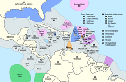
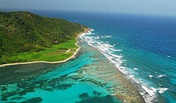
Island groups comprising the West Indies in the Caribbean
← ホームへ戻る

カリブ海地域の地理・歴史・文化多様性が織りなす群島の世界

🗓 2026年8月12日

カリブ海地域は、北米と南米に挟まれた美しい海域に広がる、数多くの島々と沿岸地域からなるダイナミックなエリアです。エメラルドグリーンの海と白い砂浜で知られるこの地域は、単なる観光地ではなく、複雑な地質学的背景、激動の植民地時代、そして多様な民族が融合して生まれた独自の文化を持つ、世界的に稀有な場所です。

この地域は一般的に「西インド諸島」とも呼ばれ、独立国から海外領土まで多様な政治的形態を持つ島々が点在しています。その成り立ちは、地球のダイナミックな地殻変動と、大西洋を渡ってきた人々による文化的な層の積み重ねによって形作られました。
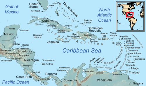
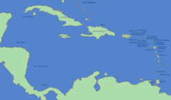
Map of the Caribbean

Key Facts

  • 総人口: 約4,418万人(人口密度 151.5人/km²)
  • 構成: 13の独立国と、米国、英国、フランス、オランダなどの海外領土で構成
  • 主要宗教: キリスト教(約73.5%)が主流で、カトリック(52.3%)が最多
  • 地理的特徴: カリブプレートの活動による火山島やサンゴ礁の島々が点在
  • 気候: 熱帯気候が支配的で、一部の地域では熱帯季節風気候が見られる

カリブ海の地理的構造と自然環境

カリブ海の島々は、主にカリブプレートという地殻プレートの相互作用によって誕生しました。北側では北米プレートとの衝突により岩石が押し上げられ、東側では沈み込み帯による火山活動が島弧(アイランドアーク)を形成しています。また、中米沿岸にはサンゴ礁による島々も見られます。
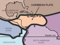
The Caribbean plate is the reason islands exist here. On the north, obduction has scraped rocks onto the North American plate (such as in western Cuba). On the east, the Lesser Antilles subduction zone produces volcanism and an island arc. Complex interactions with the South American plate has created islands along the southern boundary. Coral islands are found in insular Colombia near the east coast of Central America.

地形的には、水深100mの等深線によって浅い海底地形が定義されており、バハマやプエルトリコなどのバンク(浅瀬)が特徴的です。

Topography and bathymetry in the Caribbean with a 100 m (328 ft) depth contour, delimiting shallow underwater landforms, including the Bahamas, Puerto Rico, and Rosalind banks[32][33]

島々の分類

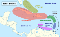
この地域の島々は、大きく分けて以下のグループに分類されます。

  • ルカヤン諸島: バハマやタークス・カイコス諸島など。
  • アンティル諸島 キューバ、ジャマイカ、イスパニョーラ島(ハイチ・ドミニカ共和国)、プエルトリコなどの大型の島々。
  • 小アンティル諸島: 北部のリーワード諸島(風上諸島)と南部のウィンドワード諸島(風下諸島)に分かれます。
  • レワード・アンティル諸島: アルバ、キュラソー、ボネールなどのABC諸島。

Island groups comprising the West Indies in the Caribbean

また、島々だけでなく、ベリーズ、コロンビア、コスタリカ、グアテマラ、ホンジュラス、ニカラグア、パナマ、メキシコ、ベネズエラといった大陸国家の沿岸部もカリブ海地域の一部として重要な役割を担っています。
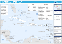
Political map of Caribbean

気候と生態系

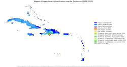
地域全体として熱帯気候に属していますが、詳細にはバリエーションがあります。例えば、コロンビアのサンアンドレス島では熱帯季節風気候が見られます。また、ケッペンの気候区分に基づいた多様な分布が確認されています。
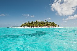
Tropical monsoon climate in San Andrés island, Caribbean, Colombia.

Köppen climate map of the islands of the Caribbean.

自然環境は豊かで、ドミニカの熱帯雨林に自生する着生植物(ブロメリアなど)や、絶滅したマルティニークアマゾンなどの希少な野生動物、色鮮やかなサンゴ礁の魚類や甲殻類など、高い生物多様性を誇ります。
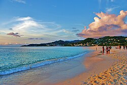
Grand Anse beach, St. George's, Grenada

歴史の変遷:先住民から現代まで

ヨーロッパ人が到達する前、この地にはアラワク系(タイノ族、シボネー族など)やカリブ系(カリナ族など)の先住民が暮らしていました。彼らは独自の言語と文化を持っていましたが、後の植民地化によって大きな影響を受けました。
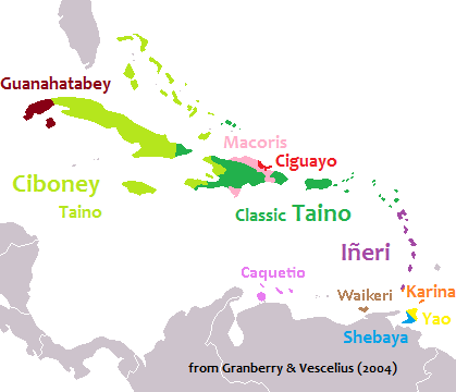
Pre-Columbian languages of the West Indies. Ciboney Taíno, Classic Taíno, and Iñeri were Arawakan, Karina and Yao were Cariban. Macorix, Ciguayo and Guanahatabey are unclassified.

植民地時代と権力争い

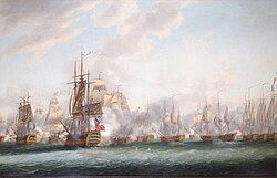
15世紀末のコロンブス到達以降、スペインが主導権を握りましたが、次第にイギリス、フランス、オランダ、デンマークなどが進出し、激しい領土争いを繰り広げました。18世紀にはイギリスとフランスの艦隊による海戦(セインツ海戦など)が起こるなど、戦略的要衝として争奪戦が続きました。
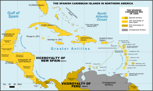
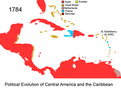
Spanish Caribbean Islands in the American Viceroyalties 1600

The mostly Spanish-controlled Caribbean in the 18th century

The mostly Spanish-controlled Caribbean in the 16th century

The Battle of the Saintes between British and French fleets in 1782, by Nicholas Pocock

脱植民地化と現代政治

20世紀に入ると、多くの島々が独立を果たし、主権国家となりました。一方で、依然として米国や英国などの海外領土として残っている地域もあります。現代では、CARICOM(カリブ共同体)などの地域機構を通じて、経済協力や政治的な連携を強めています。
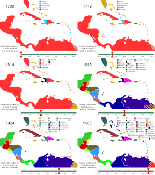
Political evolution of Central America and the Caribbean from 1700 to present

Flag of the Caribbean Common Market and Community (CARICOM)

冷戦期には、キューバの革命やピッグス湾侵攻のような政治的緊張の舞台となった歴史もあります。
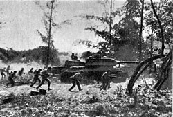
Counter-attack by Cuban Revolutionary Armed Forces supported by T-34 tanks near Playa Giron during the Bay of Pigs Invasion, 19 April 1961.

多様な文化と社会

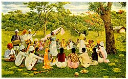
カリブ海の文化は、先住民、ヨーロッパ、アフリカ、そしてアジア(主にインド)の要素が複雑に混ざり合った「クレオール文化」が特徴です。この融合は、宗教、言語、芸術、そして食文化に色濃く反映されています。

信仰と精神世界

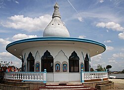
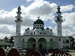
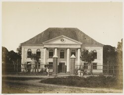
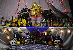
キリスト教(カトリックおよびプロテスタント)が圧倒的に多いですが、地域によってはヒンドゥー教やイスラム教、またアフリカ由来の民間信仰(ハイチのブードゥーなど)が共存しています。
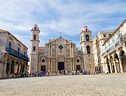
Havana Cathedral (Catholic) in Cuba completed in 1777

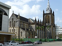
Holy Trinity Cathedral, an Anglican Christian cathedral in Trinidad and Tobago

Temple in the Sea, a Hindu mandir in Trinidad and Tobago

Muhammad Ali Jinnah Memorial Masjid, a Muslim masjid in Trinidad and Tobago

A Jewish synagogue in Suriname

A Haitian Vodou altar

食文化とライフスタイル

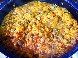
料理は、地域の特産品と移住者の伝統が融合しています。ジャマイカのジャークチキンやアキー&ソルトフィッシュ、プエルトリコのアロス・コン・ガンドゥレス、トリニダード・トバゴのダブリーズなど、多彩な国民的料理が存在します。
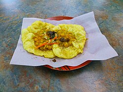
Doubles, one of the national dishes of Trinidad and Tobago

Arroz con gandules, one of the national dishes of Puerto Rico

また、スポーツにおいても独自の発展を遂げており、クリケットが深く根付いている地域がある一方で、米国占領の影響で野球が普及したドミニカ共和国のような例も見られます。

Plaquita, a Dominican street version of cricket. The Dominican Republic was first introduced to cricket through mid-18th century British contact,[92] but switched to baseball after the 1916 American occupation.[93]

カーニバルなどの祭典は、アフリカ系文化の強い影響を受けており、音楽とダンスを通じて地域のアイデンティティを表現しています。
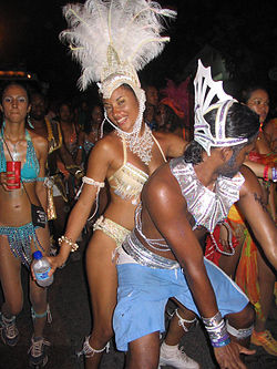
Carnival in Trinidad and Tobago

社会の多様性と景観

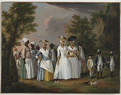
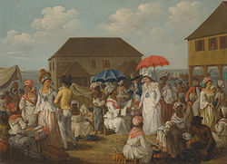
人種構成は、アフリカ系、インド系、白人系、そしてそれらが混ざり合った混血層(ミクスト)で構成されています。街並みも、キューバのハバナやキュラソーのウィレムスタットのように、ヨーロッパの建築様式と熱帯の色彩が融合した独特の景観を持っています。
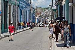
Street scene, Matanzas, Cuba

A linen market in Dominica in the 1770s

Agostino Brunias. Free Women of Color with Their Children and Servants in a Landscape, Brooklyn Museum

Asian Indians in the late nineteenth century singing and dancing in Trinidad and Tobago

自然景観においても、キューバのタバコ畑から、グアドループの山岳地帯、セントルシアのピトン山まで、多様な表情を見せてくれます。
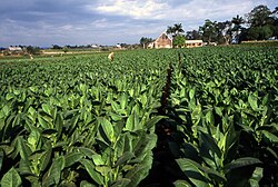
A field in Pinar del Rio planted with Cuban tobacco

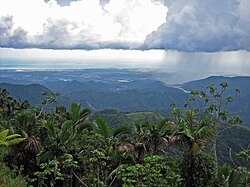
Puerto Rico's south shore, from the Cordillera Central in Jayuya

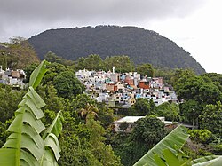
A church cemetery perched in the mountains of Guadeloupe

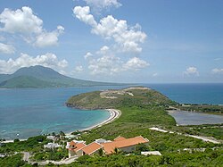
A view of Nevis island from the southeastern peninsula of Saint Kitts

地域データまとめ

カリブ海地域の主要な構成要素と特徴を以下の表にまとめます。

カリブ海地域の概要まとめ
項目 詳細内容
主要な島グループ 大アンティル、小アンティル、ルカヤン、レワード・アンティル
主な独立国 キューバ、ジャマイカ、ハイチ、ドミニカ共和国、トリニダード・トバゴなど13カ国
主要な言語・文化圏 スペイン語圏、英語圏、フランス語圏、オランダ語圏
経済・政治連携 CARICOM(カリブ共同体)、ACS(カリブ諸国協会)など
代表的な観光資源 サンゴ礁、白い砂浜、植民地時代の旧市街、火山地形

Exclusive economic zones (EEZ) in the Caribbean, with American zones in blue, British in pink, French in purple, Dutch in orange, and Ecuadorian in green

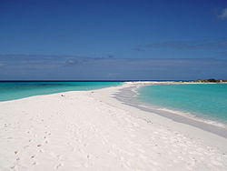
Cayo de Agua, Los Roques Archipelago, Venezuela

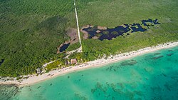
Palancar Beach in Cozumel Island, Mexico

Guanaja Island, Bay Islands, Honduras

Frequently Asked Questions

カリブ海と西インド諸島は何が違うのですか?

厳密には異なりますが、多くの場合で同じ地域を指します。「カリブ海」は地理的な海域およびその周辺地域を指し、「西インド諸島」は歴史的にヨーロッパ人がこの地域をインドの一部と誤認したことに由来する呼称で、主に島々を指します。

この地域の主な産業は何ですか?

観光業が極めて重要な経済的柱となっています。また、歴史的に重要な砂糖キビなどの農業や、一部の国では石油・天然ガスなどの資源産業も盛んです。

カリブ海で話されている言語は何ですか?

かつての植民地支配の影響で、英語、スペイン語、フランス語、オランダ語が公用語として使われています。また、これらの言語と現地語が混ざり合ったクレオール語も広く話されています。

カリブ海地域の平均寿命に傾向はありますか?

国によって大きな差があります。プエルトリコや米領ヴァージン諸島などの地域では80歳を超える高い水準にある一方、ハイチなどの国では60代半ばにとどまるなど、経済状況や医療体制による格差が見られます。

カリブ海で人気のスポーツは何ですか?

伝統的にクリケットが非常に人気のある地域(特に英連邦諸国)が多いですが、ドミニカ共和国やプエルトリコなどでは野球が国民的なスポーツとして親しまれています。

References

  1. Pronounced , locally ; : el Caribe; : les Caraïbes; : de Caraïben.
  2. The is excluded from some definitions of "Caribbean" and instead classified as ; this is primarily a geological rather than cultural or environmental distinction.
  3. Bermuda is an associate member of the Caribbean Community.
  4. 2019 estimate

📸 フォトギャラリー

Island groups comprising the West Indies in the Caribbean
Exclusive economic zones (EEZ) in the Caribbean, with American zones in blue, British in pink, French in purple, Dutch in orange, and Ecuadorian in green
Political map of Caribbean
Map of the Caribbean
Pre-Columbian languages of the West Indies. Ciboney Taíno, Classic Taíno, and Iñeri were Arawakan, Karina and Yao were Cariban. Macorix, Ciguayo and Guanahatabey are unclassified.
The Battle of the Saintes between British and French fleets in 1782, by Nicholas Pocock
Counter-attack by Cuban Revolutionary Armed Forces supported by T-34 tanks near Playa Giron during the Bay of Pigs Invasion, 19 April 1961.
The Caribbean plate is the reason islands exist here. On the north, obduction has scraped rocks onto the North American plate (such as in western Cuba). On the east, the Lesser Antilles subduction zone produces volcanism and an island arc. Complex interactions with the South American plate has created islands along the southern boundary. Coral islands are found in insular Colombia near the east coast of Central America.
Topography and bathymetry in the Caribbean with a 100 m (328 ft) depth contour, delimiting shallow underwater landforms, including the Bahamas, Puerto Rico, and Rosalind banks[32][33]
Tropical monsoon climate in San Andrés island, Caribbean, Colombia.
Köppen climate map of the islands of the Caribbean.
A field in Pinar del Rio planted with Cuban tobacco
Puerto Rico's south shore, from the Cordillera Central in Jayuya
Grand Anse beach, St. George's, Grenada
A church cemetery perched in the mountains of Guadeloupe
A view of Nevis island from the southeastern peninsula of Saint Kitts
Spanish Caribbean Islands in the American Viceroyalties 1600
Political evolution of Central America and the Caribbean from 1700 to present
The mostly Spanish-controlled Caribbean in the 18th century
The mostly Spanish-controlled Caribbean in the 16th century
Cayo de Agua, Los Roques Archipelago, Venezuela
Palancar Beach in Cozumel Island, Mexico
Guanaja Island, Bay Islands, Honduras
Flag of the Caribbean Common Market and Community (CARICOM)
A linen market in Dominica in the 1770s
Agostino Brunias. Free Women of Color with Their Children and Servants in a Landscape, Brooklyn Museum
Asian Indians in the late nineteenth century singing and dancing in Trinidad and Tobago
Street scene, Matanzas, Cuba
Carnival in Trinidad and Tobago
Havana Cathedral (Catholic) in Cuba completed in 1777
Holy Trinity Cathedral, an Anglican Christian cathedral in Trinidad and Tobago
Temple in the Sea, a Hindu mandir in Trinidad and Tobago
Muhammad Ali Jinnah Memorial Masjid, a Muslim masjid in Trinidad and Tobago
A Jewish synagogue in Suriname
A Haitian Vodou altar
Doubles, one of the national dishes of Trinidad and Tobago
Arroz con gandules, one of the national dishes of Puerto Rico
Plaquita, a Dominican street version of cricket. The Dominican Republic was first introduced to cricket through mid-18th century British contact,[92] but switched to baseball after the 1916 American occupation.[93]