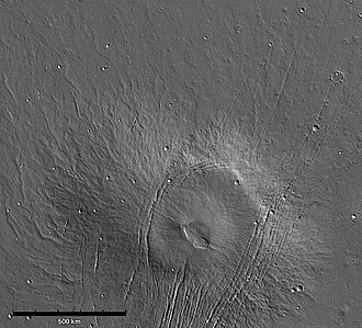
火星のタルシス地域北部には、他のどの火山とも異なる極めてユニークな構造を持つアルバ・モンズ(Alba Mons)が存在します。この火山は、高さよりもその圧倒的な「広がり」で知られており、表面積においては火星最大の火山です。地球上の火山や火星の他の巨大火山とは一線を画す、緩やかな傾斜と広大な溶岩原が特徴です。
主要な事実(Key Facts)
- 最大面積:溶岩流が頂上から少なくとも1,350kmにわたって広がっており、表面積は火星で最大。
- 低プロファイル:最高高度は6.8kmであり、オリンポス山などの巨大火山に比べて非常に低い。
- 緩やかな傾斜:北側斜面の平均傾斜はわずか0.5度と、極めて平坦に近い。
- 特異な構造:中央のドーム状の本体と、それを囲む広大な溶岩のスカート(エプロン)で構成される。
- 地質的特徴:大規模な正断層による地溝(グラベン)が発達している。
地理的規模と立地
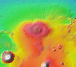
アルバ・モンズは、火星の北緯40度付近、タルシス隆起の北端に位置しています。その規模は驚異的で、南北に約2,000km、最大幅は約3,000kmに及び、面積は570万平方キロメートル以上に達します。これはアメリカ合衆国の国土面積に匹敵する広さであり、単なる一つの火山というよりも、一つの独立した火山州として捉えられるほどの規模です。
この火山の興味深い点は、南北で地形的な起伏(リリーフ)が大きく異なることです。北側では約7.1kmの起伏があるのに対し、南側では約2.6kmに留まります。これは、アルバ・モンズが火星の「二分法境界」と呼ばれる、南側の高地と北側の低地の境界線上にまたがって位置しているためです。
構造的特徴:中央ドームと溶岩エプロン
アルバ・モンズは、大きく分けて2つの同心円状の構造で構成されています。中心部には約1,500km × 1,000kmの楕円形の本体があり、その周囲をさらに1,000kmほど広がるほぼ平坦な溶岩流の層(エプロン)が取り囲んでいます。
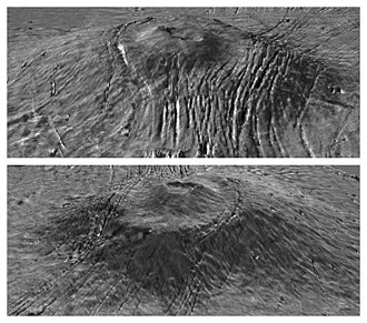
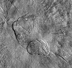
中央の本体部分は、頂上に直径350kmのドームを持ち、その頂上には入れ子状になったカルデラ複合体が存在します。このカルデラは、他のタルシス火山に見られるものよりも浅く、最大深度は1.2km程度です。全体として、部分的に崩落した盾状火山の上に、さらに小さなドームが乗っているような形状をしています。
表面の組成と環境
この地域の表面は厚い塵(ダスト)に覆われており、それが高い反射率(アルベド)と低い熱慣性をもたらしています。しかし、北側の斜面やエプロン部分では熱慣性が高く、岩石や砂、硬結層(デュリクラスト)が多く露出していると考えられています。
ガンマ線分光計(GRS)による分析では、この地域はケイ素(Si)、トリウム(Th)、カリウム(K)の含有量が比較的少なく、塩素(Cl)が平均より多いという化学的特徴を持っています。特にケイ素の少なさは、玄武岩やダンナイトのような苦味質・超苦味質火成岩で構成されていることを示唆しています。
地質学的プロセス:溶岩流と噴出メカニズム
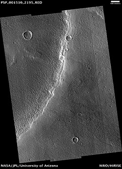
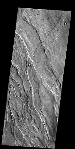
アルバ・モンズの斜面には、複数のローブが重なり合った「シートフロー(平板状溶岩流)」が見られます。これらの流れは一般に中央に流路を持たず、平坦な頂面を持つのが特徴です。厚さは20mから130mと幅がありますが、多くは末端部分で厚くなる傾向があります。
かつてはその極端に低いプロファイルから、非常に高温で流動性の高いコマタイアイトのような溶岩が噴出したという説もありました。しかし、近年の研究では、溶岩管や流路を持つ流れの解析により、粘性は一般的な玄武岩の範囲内(100〜100万 Pa s)であったことが判明しています。噴出速度は地球上の最大級の火山流(マウナロアなど)と同等か、あるいはそれを数桁上回る非常に高いレートであったと推定されています。
構造地質学:広大な断層系
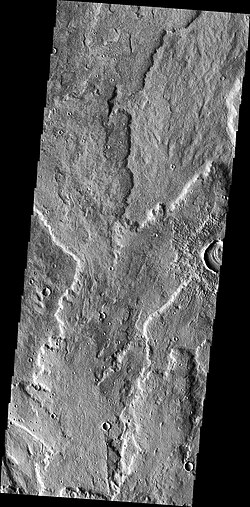
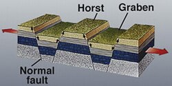
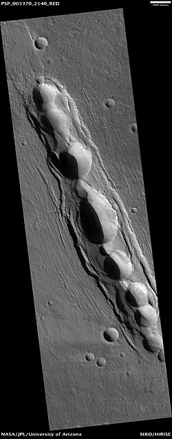
アルバ・モンズの最大の特徴の一つが、引張応力によって形成された大規模なグラベン(地溝)です。グラベンとは、2つの正断層に挟まれて沈み込んだ地塊のことです。ここでは、火星全土の中でも特に明瞭なグラベンが観察され、長さ1,000km、幅2〜10km、深さ100〜350mに達するものもあります。
これらの断層は「スウォーム(群)」として現れ、西側のアルバ・フォッサ、東側のタンタルス・フォッサ、そして南側のセラウニウス・フォッサへと繋がっています。この断層系全体で長さ3,000km、幅約1,000kmに及ぶ巨大なネットワークを形成しており、その形状はまるで「節のある木目の周囲を流れる模様」に例えられます。
![Simple graben and horsts in Tantalus Fossae on eastern flank of Alba Mons. Line of pit craters suggests drainage into subsurface voids, possibly created by tension cracks[50] (THEMIS IR daytime mosaic).](/images/85/0f/850f67dfaa269cdd0d3f3928f61b212680e798d494e070f93c46f71d65b1ebd9.jpg)
その他の地質的特徴
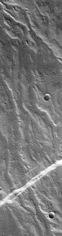
北西の斜面には谷のネットワークが存在し、これらは後の時代の断層によって切断されています。また、溶岩流が断層やグラベンによって分断されている箇所もあり、これにより「溶岩の噴出」よりも「断層の形成」の方が新しいという時間的な前後関係が分かっています。
アルバ・モンズの概要まとめ
| 項目 | 詳細データ |
|---|---|
| 最高高度 | 6.8 km |
| 最大幅 / 長さ | 約 3,000 km / 約 2,000 km |
| 表面積 | 少なくとも 570万 km² |
| 平均傾斜(北側) | 0.5度 |
| 主要構成岩石 | 玄武岩、ダンナイト(推定) |
| 主要構造 | 中央ドーム、溶岩エプロン、グラベン群 |
Frequently Asked Questions
アルバ・モンズはなぜ他の火星の火山より低いのですか?
アルバ・モンズは、垂直方向への成長よりも水平方向への溶岩の広がりが極めて強かったためと考えられています。非常に流動性の高い溶岩が広範囲に流出したことで、高さは抑えられつつ、面積だけが巨大な特異な形状となりました。
「グラベン」とは具体的にどのような地形ですか?
地殻が左右に引っ張られる力(引張応力)を受けた際に、中央部分がずり落ちてできた細長い溝状の地形のことです。アルバ・モンズでは、このグラベンが非常に大規模かつ明瞭に発達しており、惑星地質学的な研究の重要な対象となっています。
この火山の組成はどうやって調べたのですか?
表面が塵で覆われているため、通常の光学的な分光分析は困難です。そのため、マーズ・オデッセイ探査機のガンマ線分光計(GRS)を用いて、表面直下の元素分布(ケイ素、鉄、塩素など)を測定することで、岩石の組成を推定しています。
アルバ・モンズの名称の由来は何ですか?
「Alba」はラテン語で「白い」を意味し、「Mons」は「山」を意味します。したがって、日本語では「白い山」という意味になります。
この火山は現在も活動していますか?
提供されたデータに基づくと、過去に大規模な溶岩流や断層形成があったことは分かっていますが、現在活動しているという証拠は示されていません。地質学的な履歴からは、ヘスペリア紀後期からアマゾニア紀初期にかけて形成されたと考えられています。
References
- "Alba Mons". Gazetteer of Planetary Nomenclature. . Retrieved 2013-09-08.
- "Alba Patera". Gazetteer of Planetary Nomenclature. . Retrieved 2013-09-08.
- Watters, TR; Janes, DM (1995). "Coronae on Venus and Mars: Implications for similar structures on Earth". Geology. 23 (3): 200–204. :1995Geo....23..200W. :10.1130/0091-7613(1995)023<0200:COVAMI>2.3.CO;2.
- Cattermole, 2001, p. 85.
- "Mars upside down".
- Carr, 2006, p. 54.
- Plescia, J. B. (2004). "Morphometric Properties of Martian Volcanoes". J. Geophys. Res. 109 (E3): E03003. :2004JGRE..109.3003P. :10.1029/2002JE002031.
- Boyce, 2008, p. 104.
- See Carr, 2006, p. 54, Fig. 3.10 for profile of Alba Mons compared to Olympus Mons. The difference in relief is striking.
- Greeley, R.; Spudis, P. (1981). "Volcanism on Mars". Rev. Geophys. Space Phys. 19 (1): 13–41. :1981RvGSP..19...13G. :10.1029/rg019i001p00013.
📸 フォトギャラリー