現代のグローバル経済における国家間の格差は、単なる個別の国の政策や能力の差ではなく、世界規模の構造的な仕組みによって生じているという視点があります。これが世界システム論(World-Systems Theory)です。1970年代にイマニュエル・ウォーラーステインによって体系化されたこの理論は、世界を一つの巨大な経済的・政治的単位として捉え、資本主義がどのように地球全体に浸透し、不平等な構造を作り上げたかを分析します。
ウォーラーステインは、現代の資本主義世界経済が15世紀半ばから16世紀にかけて、封建制の長期的な危機という偶然の産物から誕生したと説きました。西欧諸国はこの過程で優位性を確立し、工業化と資本主義を世界に広めることで、結果として世界的な「不平等発展」を主導することになったと考えられています。
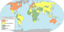
Key Facts
- 分析単位の転換: 個別の国家ではなく、世界全体を一つの「システム」として分析する。
- 三層構造: 世界を「中核(コア)」「半周辺(セミ・ペリフェリ)」「周辺(ペリフェリ)」の3つのカテゴリーに分類する。
- 資本主義の拡大: 1450年頃に誕生した資本主義世界経済は、1900年までに地球全体を覆う唯一のシステムとなった。
- 不平等のメカニズム: 中核国家が周辺国家から原材料や安価な労働力を搾取し、高付加価値の商品を輸出することで富を蓄積する。
世界システムの構造的分類
世界システム論の最大の特徴は、国家をその経済的役割と権力関係に基づいて3つの階層に分ける点にあります。この分類は固定的なものではなく、歴史的な変動の中で国家が移動することがあります。
中核(Core)
経済的に多様で、高度に工業化された富裕な国家群です。強力な中央政府と官僚機構、そして強大な軍事力を保持しています。主に金融、情報、サービスなどの高付加価値産業に特化し、他国への強い影響力を持ちながら、外部からの支配をほとんど受けない独立性を維持しています。

周辺(Periphery)
経済的な多様性が低く、原材料の抽出や一次産品の輸出に依存している国家群です。政府や社会制度が脆弱で、インフラ整備のための税基盤も不足しています。低賃金労働者が多く、中核国家による経済的支配を受けやすい傾向にあります。
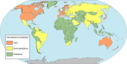
半周辺(Semi-periphery)
中核と周辺の中間に位置する国家群です。中核国家から支配を受ける一方で、周辺国家に対しては支配的な立場にあります。この層が存在することで、世界システム全体の安定性が保たれ、周辺国家にとっての「上昇の可能性」という希望が維持される役割を果たしています。
![A world map of countries by their supposed trading status in 2000, using the world system differentiation into core countries (blue), semi-periphery countries (yellow) and periphery countries (red). Based on the list in Chase-Dunn, Kawana, and Brewer (2000).[1]](/images/cf/1e/cf1ee028ca3075abc85c00dc513187d24c2ee1faa494619931b208e681cd3362.webp)
歴史的展開とグローバル化のプロセス
世界システムは、歴史的にいくつかの段階を経て進化してきました。ウォーラーステインは、16世紀から1640年のイギリス革命までを「長い16世紀」と呼び、ここを資本主義世界経済の起点としています。
それ以前のヨーロッパは封建制に支配されていましたが、14世紀から15世紀にかけて、気候変動(小氷期)による農業生産の停滞や黒死病などの疫病の流行により、深刻な危機に直面しました。この崩壊過程から、新たな経済形態である資本主義が台頭しました。
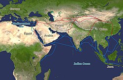
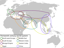
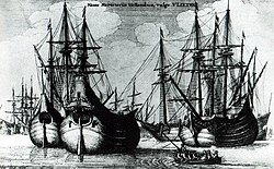
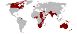
その後、17世紀にはオランダのフルート船などの輸送技術が発展し、貿易が加速しました。18世紀から19世紀にかけてはイギリスが工業化を主導し、農業中心の社会から工業社会へと転換しました。1900年までには、かつてのヨーロッパの中核国家が世界の大部分を植民地化し、地球上のほぼすべての地域がこの資本主義システムに組み込まれました。
![A world map of countries in 1965 colour-coded into 'blocks' based on trade, military interventions, diplomats and treaties:[2] Block A Block B Block C & with dashed lines indicates colonies of Block C countries Block C' Block D Block D' Block E Block E' Block F Block F'](/images/86/38/8638d5767cef059b6e8ead7c9496aa07eec45566cb9c129059fcd133ab87a236.png)
現代社会への応用と批判
世界システム論は、単なる歴史分析に留まらず、現代の環境問題や国際政治の理解にも寄与しています。例えば、G-77(発展途上国の集団)の形成は、周辺および半周辺国家がグローバルな意思決定の場での影響力を高め、経済的脆弱性を克服しようとする動きとして説明できます。
また、二酸化炭素(CO2)の排出量分析においても、GDPや輸出構造、債務状況などの指標を用いて、どの国家がシステム上のどの位置(中核か周辺か)にあるかが環境負荷の強度に影響していることが示唆されています。
一方で、この理論には批判もあります。特にラテンアメリカの思想家たちは、経済的な視点だけでなく、人種、ジェンダー、知識のあり方といった「植民地性(Coloniality)」という概念を用いて、権力の構造的な抑圧をより多角的に分析する必要性を唱えています。
世界システムの構造まとめ
| 特徴 | 中核 (Core) | 半周辺 (Semi-periphery) | 周辺 (Periphery) |
|---|---|---|---|
| 経済構造 | 高度工業化・サービス業 | 工業化が進展中 | 原材料抽出・一次産業 |
| 政治権力 | 非常に強力・自律的 | 中程度 | 脆弱・外部依存 |
| 主な役割 | 高付加価値商品の輸出 | 中継的役割・一部工業化 | 安価な労働力と資源の提供 |
| 社会構造 | 強固な中産階級・労働者層 | 混合的 | 少数のブルジョワ・多数の農民 |
Frequently Asked Questions
世界システム論と依存理論はどう違うのですか?
依存理論は主に、周辺国が中核国に依存することで低開発が固定化される点に注目しました。世界システム論はこれを継承しつつ、分析単位を「国家」から「世界システム全体」へと広げ、さらに「半周辺」というカテゴリーを導入して、システム全体のダイナミズムを説明しようとした点に違いがあります。
国家は「周辺」から「中核」へ移動できるのでしょうか?
はい、可能です。歴史的に見ても、ある国家が工業化に成功し、貿易条件を改善させ、政治的・軍事的な権力を獲得することで、周辺から半周辺へ、あるいは半周辺から中核へと上昇することがあります。
なぜ「半周辺」というカテゴリーが必要なのですか?
もし世界が「中核」と「周辺」の二極のみに分かれていれば、周辺国の不満が爆発し、システムはすぐに崩壊してしまうと考えられます。半周辺が存在することで、周辺国には「努力すれば上昇できる」という希望が生まれ、システム全体の安定性が維持されるためです。
この理論は現代のグローバル化をどう捉えていますか?
グローバル化を、過去500年にわたる資本主義の拡大プロセスそのものとして捉えています。現代のデジタル経済や金融ネットワークも、基本的には中核国家が優位性を維持し、世界的な分業体制を構築するという構造の延長線上にあると分析します。
References
- ; Kawano, Yukio; Brewer, Benjamin D. (2000). "Trade Globalization since 1795: Waves of Integration in the World-System". American Sociological Review. 65 (1): 77–95. :2000ASRev..65...77C. :10.2307/2657290. 0003-1224. 2657290. 147609071. See appendix with the country list ("Table A2"). Some countries with a population of less than one million were excluded from the analysis.
- Snyder, David; Kick, Edward L. (1979-03-01). "Structural Position in the World System and Economic Growth, 1955–1970: A Multiple-Network Analysis of Transnational Interactions". American Journal of Sociology. 84 (5): 1096–1126. :10.1086/226902. 0002-9602. 144895613. Archived from the original on 2022-04-08. Retrieved 2022-04-08.
- Immanuel Wallerstein, (2004), "World-systems Analysis." In World System History, ed. George Modelski, in Encyclopedia of Life Support Systems (EOLSS), Developed under the Auspices of the UNESCO, Eolss Publishers, Oxford, UK
- Barfield, Thomas, ed. (1998). The dictionary of anthropology. Wiley-Blackwell. pp. 498–499. . Archived from the original on 2021-07-26. Retrieved 2016-03-15.
- Frank Lechner, Globalization theories: World-System Theory Archived 2013-04-29 at the , 2001
- Wallerstein, Immanuel Maurice (2004). World-systems analysis: An introduction. Duke University Press. pp. 23–24.
- Chirot, Daniel; Hall, Thomas D. (1982). "World-System Theory". Annual Review of Sociology. 8: 81–106. :10.1146/annurev.so.08.080182.000501. 0360-0572. 2945989.
- Flint, C.; Taylor, P. J. (2018). Political Geography: world-economy, nation-state, and locality (7 ed.). Routledge. .
- Wallerstein, Immanuel (1974). The Modern World-System I: Capitalist Agriculture and the Origins of the European World-Economy in the Sixteenth Century. New York: Academic Press.
- Paul Halsall Modern History Sourcebook: Summary of Wallerstein on World System Theory Archived 2007-10-26 at the , August 1997
📸 フォトギャラリー