都市化とは、人々が生活や仕事の拠点を農村から都市へと移し、集落が拡大・成長していくプロセスを指します。これは単に都市に住む人の絶対数が増えることではなく、国全体の人口に占める都市居住者の割合が上昇することを意味します。社会構造や文化がこの変化に適応していく過程も含め、現代社会における最もダイナミックな人口変動の一つと言えるでしょう。
国連の予測によれば、2050年までに先進国の約86%、発展途上国の約67%が都市化される見込みです。特にアフリカやアジアでの成長が著しく、2050年までに約30億人が都市で生活することになるとされています。また、2017年から2030年までの世界的な人口増加のほぼすべてが都市部で起こり、10年間で約11億人の新たな都市居住者が誕生すると予測されています。
Key Facts
- 人口シフト:2050年までに世界人口の大部分が都市に集中し、特にアジアとアフリカで急増する。
- 資源の逼迫:急速な都市化は、土地の不足、飲料水の欠乏、公共スペースの減少などの「人工的な希少性」を生む。
- 環境への負荷:1992年から2015年の間に都市面積は2倍以上に拡大し、肥沃な農地や森林を大量に消費した。
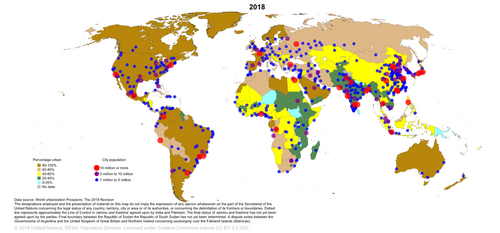
- 地域差:南米は世界で唯一、都市化率が80%を超える大陸である。
- 持続可能性:SDGsの目標11「住み続けられるまちづくりを」が、都市のレジリエンス(回復力)向上を目指している。
都市化の歴史的変遷
人類の都市形成は数千年前まで遡ります。考古学的な調査により、世界各地で初期の都市中心地がどのように誕生し、広がったかが明らかにされています。
![A global map illustrating the first onset and spread of urban centres around the world, based on.[14]](/images/d7/14/d7142ccf4a95005b7356401b1dc677a50199fb6814ed52716f9c3c71e442cd47.gif)
歴史的な転換点となったのは、18世紀後半のイギリスで起きた農業革命と産業革命です。これにより、それまでの人口バランスが崩れ、農村から都市への大規模な人口流入が加速しました。例えば、イングランドとウェールズでは、人口2万人以上の都市に住む人の割合が1801年の17%から、1891年には54%へと急増しました。同時期の他国と比較しても、1891年時点でフランスは37%、プロイセンは41%、米国は28%であり、イギリスの都市化の速さは際立っていました。
![Urbanization over the past 500 years[13]](/images/b7/82/b7822bcc38d2c5ec2146207ff4833225a20bbe3c071bdb623095b8dd4c1bd013.webp)
都市化がもたらす多角的な影響
経済と社会の構造変化
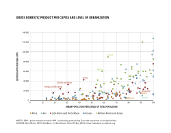
都市化は、グローバル化や近代化、産業化と密接に結びついています。経済的な視点では、一人当たりの国内総生産(GDP)と都市化率には相関関係が見られます。また、若年層が就業機会を求めて都市へ流出することで、農村部では高齢化が進むという人口統計学的な歪みが生じます。
![Population age comparison between rural Pocahontas County, Iowa and urban Johnson County, Iowa, illustrating the flight of young adults (red) to urban centres in Iowa.[22]](/images/eb/c8/ebc8dddc440d1b382ff5a18be39937803fb10b467b73e657ee11ab4088c3adee.jpg)
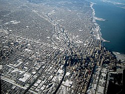
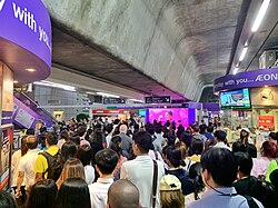
都市の形態も多様です。アメリカの初期の開発に見られるような、地形に関わらず直線的に区画を分ける「グリッドシステム」などの計画的な都市設計が行われる一方で、急速な成長に伴う過密状態に直面する都市もあります。
環境への深刻な負荷
都市の拡大は自然生態系に大きなダメージを与えます。1992年から2015年の間に、都市面積は3,300万ヘクタールから7,100万ヘクタールへと倍増しました。この過程で、2,400万ヘクタールの肥沃な農地、330万ヘクタールの森林、460万ヘクタールの低木地が消失しました。
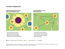
また、都市特有の環境問題として、コンクリートやアスファルトによる都市熱島現象(ヒートアイランド現象)や、不適切な排水管理による水質汚染、大量の食品廃棄物の発生などが挙げられます。さらに、野生生物の生息地が分断される「生息地の断片化」が進み、生物多様性の喪失を招いています。
世界的な都市化の現状
現在、日本、米国、カナダ、韓国、多くの欧州諸国、および南米の主要国では、都市化率が80%を超えています。一方で、依然として都市化が進んでいない地域(非都市化ベルト)はアフリカやアジアの一部に点在しています。
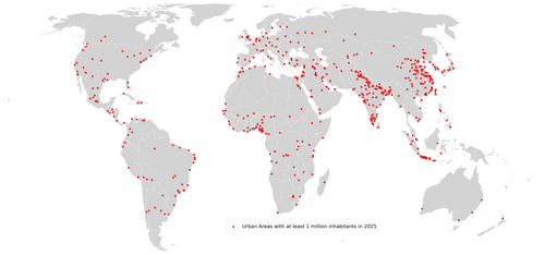
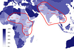
今後の課題は、単なる拡大ではなく「持続可能な都市」をいかに構築するかです。資源の効率的な利用や、自然生態系の保護を両立させた都市計画が求められています。
| 項目 | 詳細・予測値 | 主な影響・傾向 |
|---|---|---|
| 2050年の都市化率(予測) | 先進国: 86% / 発展途上国: 67% | 世界的な人口の都市集中 |
| 人口増加の傾向 | 2017-2030年の増加分はほぼ都市部 | 約11億人の新規都市居住者 |
| 環境負荷(1992-2015) | 都市面積が33Mha → 71Mhaへ拡大 | 農地・森林の大量消費 |
| 高都市化地域(80%超) | 南米、北米、日本、欧州の一部など | 南米は大陸全体で最高水準 |
Frequently Asked Questions
都市化とは具体的に何を指す言葉ですか?
単に都市の人口が増えることではなく、国全体の人口に占める都市居住者の割合が高まるプロセスを指します。これに伴う農村人口の減少や、社会・文化的な適応過程も含まれます。
急速な都市化がもたらすリスクは何ですか?
土地や飲料水、公共スペースなどの資源不足(人工的な希少性)が発生しやすくなります。また、環境面ではヒートアイランド現象や水質汚染、生物多様性の低下などの問題が深刻化します。
歴史的に都市化が加速したのはいつ頃からですか?
18世紀後半のイギリスにおける農業革命と産業革命が大きな転換点となりました。これにより、農村から都市への大規模な人口移動が始まり、19世紀を通じて世界的に都市人口が急増しました。
都市化と持続可能性はどのように関係していますか?
現在の大量消費的な都市化は持続不可能ですが、適切に計画された都市は、資源をより効率的に利用し、自然生態系を保護できる可能性を秘めています。このため、SDGsの目標11で「持続可能な都市とコミュニティ」の実現が掲げられています。
References
- "Urbanization in". demographic partitions. 28 January 2014. Archived from the original on 22 October 2018. Retrieved 8 July 2015.
- "Urbanization". MeSH browser. National Library of Medicine. Archived from the original on 16 March 2016. Retrieved 5 November 2014.
The process whereby a society changes from a rural to an urban way of life. It refers also to the gradual increase in the proportion of people living in urban areas.
- Tacoli, Cecilia (2015). Urbanisation, rural-urban migration and urban poverty. McGranahan, Gordon, Satterthwaite, David. London: International Institute for Environment and Development. . 942419887.
- "Urban life: Open-air computers". The Economist. 27 October 2012. Archived from the original on 5 September 2017. Retrieved 20 March 2013.
- "Urbanization". UNFPA – United Nations Population Fund. Archived from the original on 26 May 2020. Retrieved 11 May 2015.
- Barney Cohen (2015). "Urbanization, City Growth, and the New United Nations Development Agenda". Vol. 3, no. 2. Cornerstone, The Official Journal of the World Coal Industry. pp. 4–7. Archived from the original on 27 June 2015. Retrieved 26 June 2015.
- Dutt, A.K.; Noble, A.G.; Venugopal, G.; Subbiah, S. (2006). Challenges to Asian Urbanization in the 21st Century. GeoJournal Library. Springer Netherlands. . Retrieved 22 March 2023.
- Sridhar, K.S.; Mavrotas, G. (2021). Urbanization in the Global South: Perspectives and Challenges. Taylor & Francis. . Retrieved 22 March 2023.
- Schroeder, Ralph (2020). "Weberian Social Theory: Rationalization in a Globalized World". The Oxford Handbook of Max Weber. . pp. 150–166. :10.1093/oxfordhb/9780190679545.013.9. .
- Gries, T.; Grundmann, R. (2018). "Fertility and modernization: the role of urbanization in developing countries". . 30 (3): 493–506. :10.1002/jid.3104.
📸 フォトギャラリー