南米アルゼンチンの北西部、アンデス山脈の懐に抱かれたサラル・デ・アリサロは、息をのむような白銀の世界が広がる巨大な塩湖(サラル)です。サルタ州のロス・アンデス県に位置し、トラル・グランデやカイペといった集落の間に広がるこの地は、地球規模で見ても極めて希少な景観と資源を併せ持っています。
「アリサロ」という名称は、アタカメーニョ語で「コンドル」を意味する言葉と、「場所」や「集まり」を意味する言葉に由来していると言われています。まさに、高地の自然が凝縮された聖域のような場所です。
主要な事実(Key Facts)
- 世界規模の広さ: 面積は約1,600平方キロメートルに及び、世界で6番目、アルゼンチン国内では2番目に大きな塩湖です。
- 標高: 海抜3,460メートルという極めて高い位置に形成されています。
- 戦略的資源: 「リチウムトライアングル」の一部であり、炭酸リチウムの抽出に向けた評価が進んでいます。
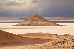
- 特異な地形: 砂岩でできた円錐形の丘「コノ・デ・アリタ」が象徴的なランドマークとなっています。
地質学的特徴と景観
サラル・デ・アリサロは、プナ・デ・アタカマの中央西部に位置しています。この地域の地表は、風による浸食と塩の結晶化という過酷な自然現象によって形作られています。特に、柔らかい岩石が風に削られて形成される「ヤルダン」と呼ばれる砂塵の丘や、塩の結晶成長による風化で鋭いエッジを持つ丘など、地球外惑星を彷彿とさせる独特の地形が見られます。
![The dry lakebeds and yardangs in Salar de Arizaro, imaged by NASA's Earth Observing-1 satellite. In the upper left corner, small rounded bumps in the landscape are yardangs, dusty hills formed when soft rocks are weathered and abraded by winds. The yardangs are aligned precisely with the northwesterly winds. On the right, bulbous hills have sharps edges, a formation typical of salt weathering around the base. During salt weathering, rocks are eroded by repeated salt crystal growth. The eroded material has been blown away by the strong winds of the high desert, leaving the sharp edge.[2]](/images/7b/f0/7bf04da7bd83cdf10338cb5e11e058979693a63ddb55f6b4bcc92c715af81ef9.jpg)
また、この広大な塩原の中には、周囲の平坦な景色とは対照的な、砂岩からなる円錐形の丘コノ・デ・アリタ(またはセロ・コノ)がそびえ立っています。この特異な造形は、訪れる人々を魅了して止みません。
天然資源と経済的価値
この地域は単なる観光地ではなく、重要な鉱物資源の宝庫でもあります。地中には塩だけでなく、大理石、鉄、銅、オニキスといった金属・非金属資源が豊富に眠っています。
特に注目されているのが、次世代エネルギーに不可欠なリチウムです。サラル・デ・アリサロは、世界的なリチウム埋蔵地である「リチウムトライアングル」に位置しており、現在はLithium Chile社やLiTHIUM-X社などの企業によって、炭酸リチウム抽出のための調査・評価が行われています。
地理的データまとめ
| 項目 | 詳細 |
|---|---|
| 所在地 | アルゼンチン共和国 サルタ州 |
| 最大長 / 最大幅 | 100 km / 50 km |
| 表面積 | 約1,600 km² |
| 表面標高 | 3,460 m |
| 主な資源 | リチウム、塩、大理石、鉄、銅、オニキス |
| 主要アクセス | サルタ=アントファガスタ鉄道、州道27号線 |
よくある質問(FAQ)
サラル・デ・アリサロはどのくらいの大きさですか?
面積は約1,600平方キロメートルで、世界的に見ても6番目に大きな塩湖です。アルゼンチン国内では、サリナス・グランデスに次いで2番目の規模を誇ります。
「リチウムトライアングル」とは何ですか?
南米のアンデス地域(主にアルゼンチン、ボリビア、チリ)にまたがる、世界最大級のリチウム埋蔵量を有する地域のことを指します。サラル・デ・アリサロはこの戦略的なエリアに含まれています。
コノ・デ・アリタとはどのような場所ですか?
塩原の中に突如として現れる、砂岩で構成された円錐形の丘のことです。平坦な塩湖の中で非常に目立つランドマークとなっており、その成り立ちについて多くの関心を集めています。
どのような鉱物が採掘されていますか?
塩のほか、大理石、鉄、銅、オニキスなどの資源が存在します。現在は特に、電気自動車などのバッテリーに使用される炭酸リチウムの抽出に向けた評価が進められています。
周辺にはどのような塩湖がありますか?
北側のカタマルカ州にあるアントファジャやオンブレ・ムエルト、東側のポシトス、そしてフフイ州とサルタ州にまたがるサリナス・グランデスなどが近隣に位置しています。
References
- (in Spanish) An article about the Salar de Arizaro archived 2013-01-14 at
- Salar de Arizaro at NASA
- Vaisse, Emilio F. (1 January 1895). "Glosario de la lengua atacameña". Anales de la Universidad de Chile (in Spanish): 533. :10.5354/anuc.v0i-.20911. 0717-8883.
- (in Spanish) SEGEMAR (Sistema Geológico Minero Argentino) "Sales" Archived 2014-10-06 at the . Publicación técnica SEGEMAR – UNSAM Nº 9 – Diciembre 2003 – 0329-5230 – Dic. 2003.
- (in Spanish) List of greatest Salares at es.wp
- Salar de Arizaro at mindat.org
- Salar de Arizaro Earth Snapshot
- (in Spanish) A picture of the Cerro Cono with a brief description Archived 2014-03-04 at the
- (in Spanish) Noticiero Salta: ¿El Cono de Arita es natural o un monumento milenario? Archived 2013-02-01 at the
- "Lithium Chile - Salar de Arizaro".
📸 フォトギャラリー