The Pacific Ring of Fire, with trenches marked with blue lines
← ホームへ戻る

環太平洋火山帯(リング・オブ・ファイア)のメカニズムと世界的な影響

🗓 2026年8月9日

太平洋の縁をぐるりと囲むように、地震や火山活動が集中している巨大な地質学的帯域が存在します。これが環太平洋火山帯リング・オブ・ファイア)です。全長は約40,000kmに及び、幅は最大で500kmに達します。地球上の活火山や休火山の約3分の2にあたる750から915もの火山がこのエリアに集中しており、地球で最もダイナミックな地殻変動が起きている場所と言えます。
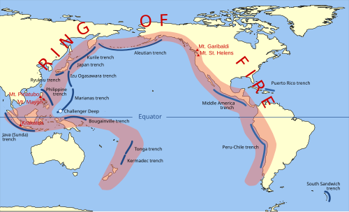
The Pacific Ring of Fire, with trenches marked with blue lines

Key Facts

  • 規模:全長約40,000km、幅最大500kmの巨大なテクトニクス帯。
  • 火山の集中:世界全体の約3分の2(750〜915基)の火山が分布。
  • 地震の頻度:世界で発生するマグニチュード8.0以上の巨大地震の多くがここで発生。
  • 主因:プレートの沈み込み(サブダクション)による地殻活動。

地質学的メカニズム:なぜ火山と地震が集中するのか

この地域で激しい活動が起こる最大の理由は、沈み込み帯(サブダクション・ゾーン)の存在です。これは、海洋プレートが他のプレートの下に潜り込む現象を指します。プレートが沈み込む際、地下深くで岩石が溶けてマグマが発生し、それが地表に噴出したものが火山となります。
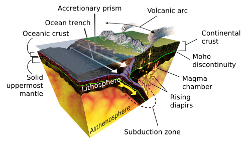
Diagram of the geological process of subduction

また、プレート同士が激しくぶつかり合い、蓄積された歪みが一気に解放されることで、巨大な地震が発生します。特に、沈み込み帯で発生する「メガスラスト地震」は、壊滅的な被害をもたらす巨大地震の原因となります。
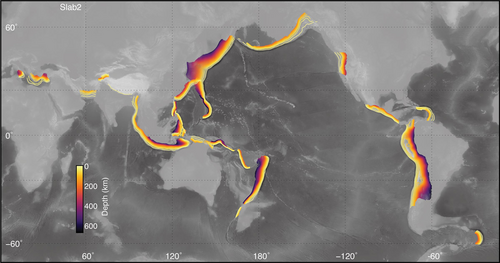
Global map of subduction zones, with subducted slabs contoured by depth

プレート配置の変遷

現在の環太平洋火山帯の形は、数千万年かけて形成されました。約1億2000万年前にはファラロンプレートやイザナギプレートといった、現在は消失または縮小したプレートが北米やアジアの下に沈み込んでいました。約3500万年前になると、現在の太平洋プレートを中心とした配置に近づき、現在のリング・オブ・ファイアの輪郭が形作られました。
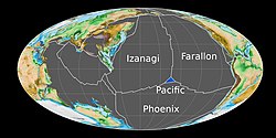
The tectonic plates of the Pacific Ocean in the Early Jurassic (180 Ma)

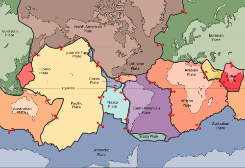
Present-day principal tectonic plates of the Earth

世界各地の火山帯と特徴的な地形

環太平洋火山帯は、地域によって異なる地質学的特徴を持っています。沈み込みの角度やプレートの性質により、チリ型(浅い角度で沈み込む)やマリアナ型(急角度で沈み込む)といった異なるタイプの沈み込み帯が存在します。
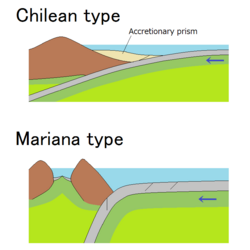
Chilean-type and Mariana-type subduction zones

南北アメリカ大陸

南米ではアンデス山脈に沿って火山が連なり、世界最高峰の活火山であるオホス・デル・サラド(標高6,893m)や、歴史的に活動が確認されている最高峰のリュライアコ山が存在します。北米では、カスケード火山弧が形成されており、ゴルダプレートやフアン・デ・フカプレートの沈み込みによって多くの成層火山や溶岩ドームが作られています。
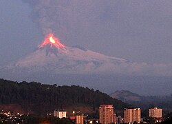
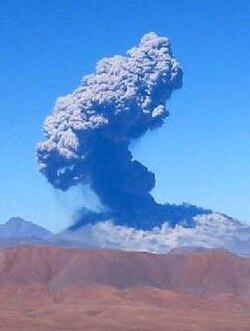
Llaima's 2008 eruption

Lascar erupting in 2006

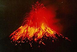
Tungurahua erupting molten lava at night (1999)

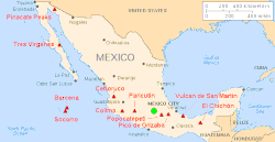
The Trans-Mexican Volcanic Belt

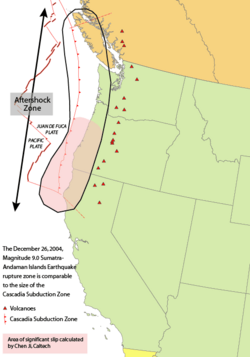
Area of the Cascadia subduction zone, including the Cascade Volcanic Arc (red triangles)

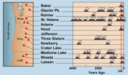
American Cascade Range volcano eruptions in the last 4000 years

アジア・オセアニア地域

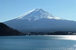
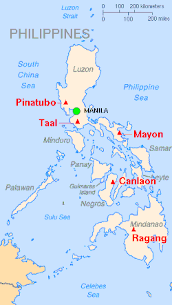
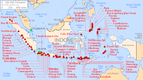
ロシアのカムチャツカ半島や日本列島は、世界でも有数の火山密集地帯です。特に日本は太平洋プレートとフィリピン海プレートの沈み込みにより、極めて不安定な地殻構造を持っており、年間1,500回もの地震が記録されています。また、インドネシアやフィリピン、ニュージーランドなどの島弧でも激しい火山活動が見られ、海底火山も数多く存在します。
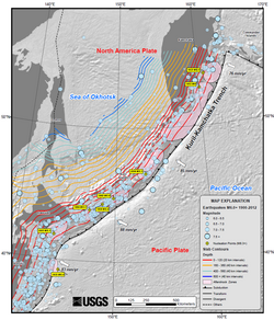
Map of earthquake epicenters at the Kuril–Kamchatka trench and subduction zone

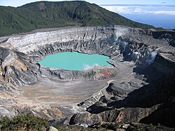
Crater of Poás volcano in Costa Rica, 2004

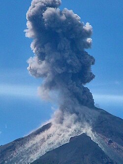
Santiaguito Volcano, 2003 eruption in Guatemala

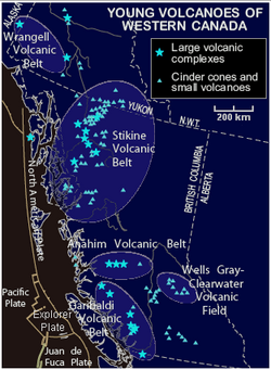
Map of young volcanoes in Western Canada

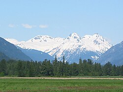
The Mount Meager massif as seen from the east near Pemberton, British Columbia: Summits left to right are Capricorn Mountain, Mount Meager, and Plinth Peak.

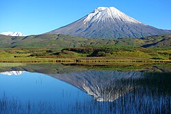
Kambalny, an active volcano in the Kamchatka Peninsula

Mount Fuji at sunrise from Lake Kawaguchi

Map showing major volcanoes of the Philippines

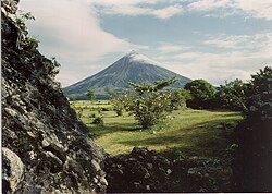
Mayon Volcano overlooks a pastoral scene about five months before the volcano's violent eruption in September 1984.

A chart with the heading "Major Volcanoes of Indonesia (with eruptions since 1900 A.D.)". Depicted below the heading is an overhead view of a cluster of islands.

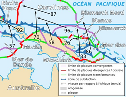
Papua New Guinea and tectonic plates: Pacific plate, Australian plate, Caroline plate, Banda Sea plate (as "Mer de Banda"), Woodlark plate, Bird's Head plate, Maoke plate, Solomon Sea plate, North Bismarck plate, South Bismarck plate and Manus plate (in French)

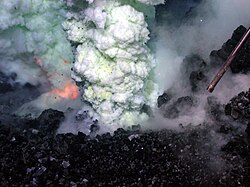
Volcanic eruption at West Mata submarine volcano between Samoa and Tonga, 2010

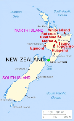
Major volcanoes of New Zealand

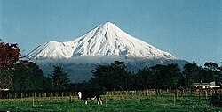
View of Mount Taranaki from Stratford

記録的な自然災害の歴史

環太平洋火山帯では、地球史上最大規模の噴火と地震が繰り返し発生しています。完新世(約11,700年前から現在まで)における世界最大級の噴火25件のうち、20件がこのエリアで発生しました。アラスカのフィッシャーカルデラや日本の口之辺(キカイ)カルデラなどがその例です。
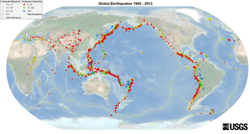
Global earthquakes (1900–2013): Earthquakes of magnitude ≥ 7.0 (depth 0–69 km (0–43 mi)): Active volcanoes

地震においても、1960年のチリ地震(Mw 9.4–9.6)や2011年の東日本大震災(Mw 9.0–9.1)など、観測史上最大級の地震のほとんどがこの帯域の沈み込み帯で発生しています。
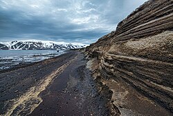
Layers of phreatomagmatic tephra on Deception Island

地域別火山分布まとめ

以下は、環太平洋火山帯における主要な地域と火山の分布状況をまとめた表です。

地域別火山分布と地質学的特徴
地域/国 沈み込み関連火山数 その他の火山数 主な特徴
チリ 71 0 アンデス山脈の激しい活動
アメリカ(アラスカ) 80 4 アレウーシャン弧の形成
日本 81 0 複数のプレートが交差する不安定地帯
インドネシア(西・東) 124 0 世界有数の火山密度
ニュージーランド 20 0 若い流紋岩質火山の集中

Frequently Asked Questions

なぜ「リング(環)」と呼ばれているのですか?

太平洋を囲むように馬蹄形(あるいは円形)に火山や地震の発生地帯が連なっているため、このように呼ばれています。

この地域で地震が多いのはなぜですか?

海洋プレートが大陸プレートの下に沈み込む際、プレート境界に強大なエネルギーが蓄積され、それが限界に達して急激に解放されるためです。

世界で最も高い活火山はどこにありますか?

南米アンデス山脈のチリとアルゼンチンの国境にあるオホス・デル・サラド(標高6,893m)です。

海底火山もリング・オブ・ファイアに含まれますか?

はい。マリアナ諸島やトンガ、ニュージーランド周辺など、海面下に存在する多くの火山もこの帯域の一部として機能しています。

過去に最大級の噴火が起きたのはどこですか?

完新世において、アラスカのフィッシャーカルデラや日本のキカイカルデラなど、この帯域で世界最大規模の噴火が複数回発生しています。

References

  1. : cinturón de fuego del Pacífico, anillo de fuego del Pacífico; : Lingkaran api Pasifik; : Cincin Api Pasifik; : Singsing ng Apoy ng Pasipiko; : 环太平洋火山带 Huán Taìpíngyáng Huǒshān Daì; : Тихоокеанское вулканическое огненное кольцо, Tikhookeanskoye vulkanicheskoye ognennoye kol'tso; : 環太平洋火山帯, Kantaiheiyō kazan-tai or 環太平洋造山帯 Kantaiheiyō zōzantai.
  2. Macdonald (1972) listed 361 historically active volcanoes in the Ring of Fire (or 398 historically active volcanoes if the western islands of Indonesia are included).
  3. Twenty-two if the western islands of Indonesia are included.
  4. if Antarctica and the western islands of Indonesia are excluded
  5. 79 of 95 earthquakes (if the western islands of Indonesia are excluded).

📸 フォトギャラリー

The Pacific Ring of Fire, with trenches marked with blue lines
Global earthquakes (1900–2013): Earthquakes of magnitude ≥ 7.0 (depth 0–69 km (0–43 mi)): Active volcanoes
Global map of subduction zones, with subducted slabs contoured by depth
Diagram of the geological process of subduction
The tectonic plates of the Pacific Ocean in the Early Jurassic (180 Ma)
Present-day principal tectonic plates of the Earth
Chilean-type and Mariana-type subduction zones
Map of earthquake epicenters at the Kuril–Kamchatka trench and subduction zone
Layers of phreatomagmatic tephra on Deception Island
Llaima's 2008 eruption
Lascar erupting in 2006
Tungurahua erupting molten lava at night (1999)
Crater of Poás volcano in Costa Rica, 2004
Santiaguito Volcano, 2003 eruption in Guatemala
The Trans-Mexican Volcanic Belt
Area of the Cascadia subduction zone, including the Cascade Volcanic Arc (red triangles)
American Cascade Range volcano eruptions in the last 4000 years
Map of young volcanoes in Western Canada
The Mount Meager massif as seen from the east near Pemberton, British Columbia: Summits left to right are Capricorn Mountain, Mount Meager, and Plinth Peak.
Kambalny, an active volcano in the Kamchatka Peninsula
Mount Fuji at sunrise from Lake Kawaguchi
Map showing major volcanoes of the Philippines
Mayon Volcano overlooks a pastoral scene about five months before the volcano's violent eruption in September 1984.
A chart with the heading "Major Volcanoes of Indonesia (with eruptions since 1900 A.D.)". Depicted below the heading is an overhead view of a cluster of islands.
Papua New Guinea and tectonic plates: Pacific plate, Australian plate, Caroline plate, Banda Sea plate (as "Mer de Banda"), Woodlark plate, Bird's Head plate, Maoke plate, Solomon Sea plate, North Bismarck plate, South Bismarck plate and Manus plate (in French)
Volcanic eruption at West Mata submarine volcano between Samoa and Tonga, 2010
Major volcanoes of New Zealand
View of Mount Taranaki from Stratford