南アジアに位置するパキスタン・イスラム共和国は、豊かな歴史的遺産と多様な自然環境、そして強固な宗教的アイデンティティを持つ国家です。世界第5位の人口を抱えるこの国は、古代文明の揺籃の地から近代国家への転換を経て、現在も地域的な重要性を維持し続けています。
主要な事実(Key Facts)
- 人口: 約2億4,150万人(2023年国勢調査)で世界第5位。
- 公用語: ウルドゥー語および英語。
- 宗教: 国教であるイスラム教が人口の96.3%を占める。
- 政治体制: 連邦議会制のイスラム共和国。
- 主要都市: 首都はイスラマバード、最大都市はカラチ。
- 経済規模: PPPベースのGDPは約1.8兆ドル(2026年予測)。
歴史的変遷:古代から独立まで
パキスタンの地は、古くから多様な文化が交差する場所でした。初期にはガンダーラ美術に代表される仏教文化が栄え、その後、中世にはイスラム教が浸透し、ムガル帝国などの強力な王朝が統治しました。
![Standing Buddha from Gandhara (1st–2nd century CE)[38]](/images/1d/ae/1dae14016e96edb7fec12c1371a35ff43be76f767d87d00b09e788841229289e.webp)
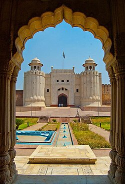
ムガル帝国時代の建築遺産は今も色濃く残り、ラホール城などの世界遺産がその栄華を伝えています。また、サマ王朝時代に発展したマクリのネクロポリスのような大規模な墓地も、この地の歴史的な深さを物語っています。
![Makli Necropolis, a UNESCO World Heritage Site rose to prominence as a major funerary site during the Samma dynasty.[60]](/images/b5/b5/b5b5e8da969c9b856f331662e8014bf30d453a06289fe1a0821857c329e5f11b.jpg)
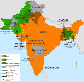
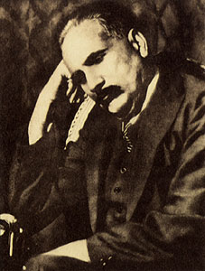
19世紀に入るとイギリスの植民地支配(イギリス領インド帝国)下に置かれましたが、ムハンマド・イクバールの思想やムスリム連盟の活動により、ムスリムのための独立国家という概念が具体化しました。1947年8月14日、ついにイギリスから独立し、パキスタンとして誕生しました。
独立後の政治的歩み
独立後、リアカット・アリー・ハーンが初代首相に就任し、国家の基盤構築に乗り出しました。その後、軍事政権と民主政権が交互に現れる不安定な時期を経験しながらも、1973年に現在の憲法が採択されました。
![Liaquat Ali Khan was elected the first prime minister of Pakistan.[108][109]](/images/7d/c2/7dc2d05ee7c476d90356b03ae936701cc13c91cd8af611da39f553e521acf24d.jpg)
外交面では、インドとの緊張関係が続き、1965年の紛争後にはタシケント宣言によって停戦に至りました。また、中国とは強固な友好関係を築いており、外交・経済の両面で密接に連携しています。
![Signing of the Tashkent Declaration to end hostilities with India in 1965 in Tashkent, USSR, by President Ayub alongside Bhutto (centre) and Aziz Ahmed (left)[125]](/images/cc/1c/cc1cdb89aab66a3a42e77704c656d603018f9e6ff96555bc5bc72810cc312886.jpg)
![Pakistani Prime Minister Huseyn Shaheed Suhrawardy with Chinese Premier Zhou Enlai signing the Treaty of Friendship Between China and Pakistan.[308] Pakistan is host to China's largest embassy.[309]](/images/ee/90/ee90dd0e899593d72604c4fd4e04969975a9d91c3ad9c07f8f91e96417a56d30.jpg)
地理的特徴と自然環境
パキスタンの地形は非常に多様です。北端には世界最高峰の山々が連なり、南端にはアラビア海に面した海岸線が広がっています。この劇的な地形の変化は、衛星写真からも明確に見て取れます。
![A satellite image showing the topography of Pakistan[178]](/images/ff/ae/ffaedefd25a342731c85a258849e1212f57c97a02e06c9ac4ad1023ddffb9f9f.jpg)
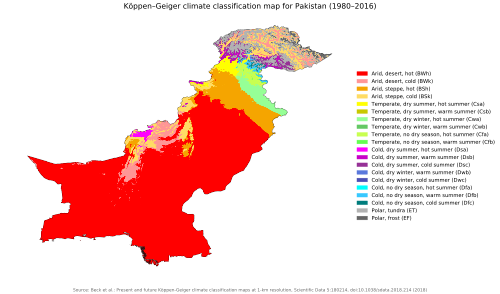
気候はケッペンの気候区分に基づき、乾燥地帯から湿潤な地域まで幅広く分布しています。特に北部のギルギット・バルティスタン地方には、美しいシャンリラ湖のような絶景が点在しています。
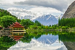
野生動物においては、国獣であるマルコール(野生ヤギの一種)が象徴的であり、豊かな生物多様性を保持しています。
![Markhor is the national animal of Pakistan.[199]](/images/c1/e0/c1e03e59e1da5fe5e6cf45cbb911775bb63d329b7dad77b17b83782e4ded8611.jpg)
行政区分と社会構造
パキスタンは複数の州と連邦直轄地で構成されています。人口の大部分はパンジャブ州に集中しており、経済の中心地であるシンド州のカラチなどの大都市が重要な役割を果たしています。
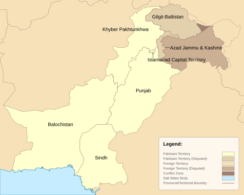
主要行政区分の概要
| 行政単位 | 州都/中心都市 | 人口(概数) |
|---|---|---|
| パンジャブ州 | ラホール | 127,688,922 |
| シンド州 | カラチ | 55,696,147 |
| ハイバル・パフトゥンクワ州 | ペシャワール | 40,856,097 |
| バローチスターン州 | クエッタ | 14,894,402 |
| イスラマバード連邦直轄地 | イスラマバード | 2,363,863 |
政治の中心的機能は、首都イスラマバードにある国会議事堂、首相官邸、最高裁判所などの政府機関に集約されています。
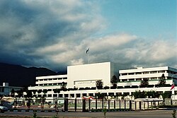
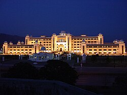
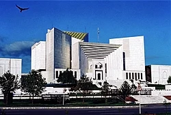
経済とインフラストラクチャー
パキスタン経済は農業、工業、サービスの3つの柱で成り立っています。特に農業分野では、世界第6位のデーツ(ナツメヤシ)生産量を誇るなど、強みを持っています。
![Pakistan is the 6th largest producer of dates in the world[430]](/images/41/cd/41cdef549df5804058878b5680b8fb0ce3612598f40e58d89d1c02b43b84cd32.jpg)
インフラ面では、中国とを結ぶカラコルムハイウェイのような世界有数の高地道路や、世界最大級の土堤ダムであるタルベーラダムなどの大規模プロジェクトが経済発展を支えています。
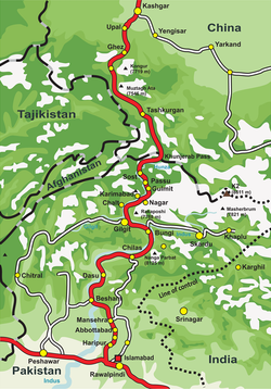
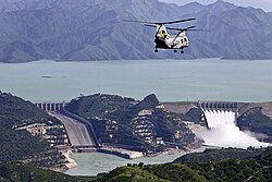
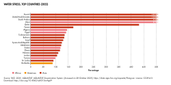
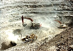
一方で、水ストレス(水不足)の問題は深刻であり、2022年時点では世界で16番目に水ストレスの高い国とされています。また、シンド州などで行われている露天掘り採掘などの資源開発も経済の重要な一部です。
文化、宗教、そして教育
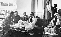
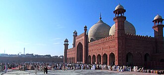
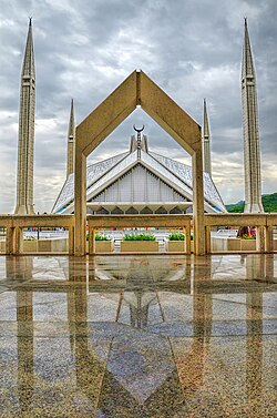
イスラム教が社会の根幹にあり、バドシャヒ・モスクでの礼拝や、サウジアラビアの支援で建設されたファイサル・モスクなどは、信仰心の深さを象徴しています。
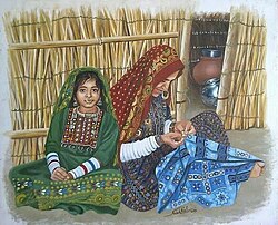
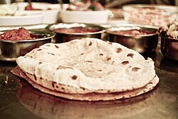
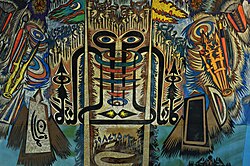
文化的には、伝統的なサルワール・カミーズという服装が一般的であり、食文化ではロティが主食として親しまれています。また、芸術分野ではサデクアインのような著名な画家・書道家が輩出されました。
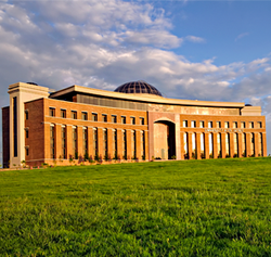
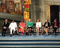
教育面では、NUST(国立科学技術大学)のような高度な工科大学が育成を担っています。また、女子教育の権利を訴え、史上最年少でノーベル平和賞を受賞したマララ・ユスフザイのような人物は、世界的な影響を与えました。
国際関係と安全保障
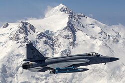
パキスタンは、上海協力機構(SCO)やイスラム協力機構(OIC)、南アジア地域協力連合(SAARC)などの国際組織で重要な役割を果たしています。特に中国との関係は極めて密接であり、軍事的な協力関係も深く、JF-17サンダーのような共同開発機も運用しています。
![Prime Minister Shehbaz Sharif at the 2022 Shanghai Cooperation Organisation summit[294]](/images/56/af/56affc69536e1fb9cc6cc3c83e700a35f8cc31e5fd529dbdea221faef217a2e8.jpg)
また、米国との関係も歴史的に複雑であり、アユブ・カーン大統領時代にはジョン・F・ケネディ大統領と会談するなど、冷戦期から戦略的な関係を維持してきました。
![President Ayub Khan meeting with U.S. President John F. Kennedy in 1961[286]](/images/2a/b2/2ab2b94567de3d7bdb1863e234725612461bb03e61883ea7fe4b31b98f04aec8.jpg)
一方で、カシミール地方を巡るインドとの領土問題は依然として解決しておらず、外交上の最大の課題となっています。2004年にはムシャラフ大統領とヴァジュパイ首相が会談し、対話の模索が行われました。
![The areas shown in green are the Pakistani-controlled areas.[345]](/images/53/73/53730883584c257c0c4316ca14cd32da04237c48eb9ebf4aecd46cbe424dd41f.jpg)
![President Musharraf meets with Indian Prime Minister Vajpayee in Islamabad at the sidelines of the 12th SAARC summit in 2004.[146]](/images/49/35/49355ec63e316204d896c18e9076baef37f91c97cea82d1cc728e79c22c5d44d.jpg)
さらに、隣国アフガニスタンからの難民受け入れなど、人道的な課題にも直面しており、かつてはトルコに次いで世界第2位の難民受け入れ数を記録したこともあります。
![Afghan children near Islamabad fetching water from water pump. (Pakistan once held the second largest refugee population globally after Turkey.[534])](/images/75/9f/759fcdff0f95643d95f248fe88215be520b1775509374d8c8210a94575b71ea6.jpg)
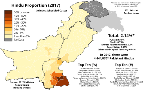
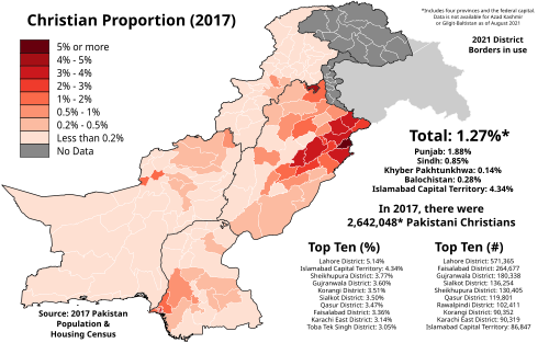
宗教的な多様性については、イスラム教以外にもヒンドゥー教やキリスト教のコミュニティが存在しており、地域によってその分布が異なります。
Frequently Asked Questions
パキスタンの公用語は何ですか?
公用語はウルドゥー語と英語の2つです。ただし、国内には77以上の多様な言語が話されています。
パキスタンの主要な産業は何ですか?
農業(特にデーツなどの農産物)、テキスタイルなどの工業、そしてサービス業が経済を支えています。
パキスタンの政治体制はどうなっていますか?
連邦議会制のイスラム共和国であり、大統領と首相がそれぞれの役割を担っています。立法府は上院(元老院)と下院(国民議会)の二院制です。
インドとの関係における最大の争点は何ですか?
カシミール地方の領有権を巡る紛争が最大の争点となっており、長年にわたり外交的・軍事的な緊張状態が続いています。
パキスタンの人口規模はどのくらいですか?
2023年の国勢調査によると、人口は約2億4,150万人に達しており、世界で5番目に人口が多い国です。
References
- Article 251 of the
- The designates Islam as the state religion.
- "Includes data for Pakistani territories of Kashmir; (13,297 km2 or 5,134 sq mi) and (72,520 km2 or 28,000 sq mi). Excluding these territories would produce an area figure of 796,095 km2 (307,374 sq mi)."
- "This figure does not include data for Pakistan-administered areas of Kashmir; Azad Kashmir and Gilgit-Baltistan, which, according to 2017 Pakistani census, had a population of 4,045,367 and 1,492,924 respectively."
- See .
- : پَاکِسْتَان, Urdu pronunciation: ; Pronounced variably in English as , , , and .
- : اِسْلامی جُمْہُورِیَہ پَاکِسْتَان, Islāmi Jumhūriyāh Pākistān
- The precise time span of the period is uncertain. and evidence indicates that the , the oldest of the Vedas, was composed roughly between 1700 and 1100 BCE, also referred to as the early Vedic period. Oberlies gives an estimate of 1200–1100 BCE for the youngest hymns in book ten. Estimates for a terminus post quem of the earliest hymns are more uncertain. Other 'cumulative evidence' sets a wide range of 1700–1100.
- The World Bank data lists the total area of Pakistan as 770,880 km², excluding Gilgit-Baltistan, Azad Kashmir, and water areas.
- In the framework of their regional security complex theory (RSCT), Barry Buzan and Ole Waever differentiate between superpowers and great powers which act and influence the global level (or system level) and regional powers whose influence may be large in their regions but have less effect at the global level. This category of regional powers includes Brazil, Egypt, India, Iran, Iraq, Israel, Nigeria, Pakistan, Saudi Arabia, South Africa and Turkey.
📸 フォトギャラリー