潮汐のメカニズムと海洋現象の科学

地球上の海面は、一定の周期を持って上昇と下降を繰り返しています。この現象を潮汐と呼び、私たちの日常生活から海洋生態系、さらには船舶の航行に至るまで多大な影響を与えています。一般的に、潮汐は1日に約2回の満潮と干潮が訪れるサイクルを持っています。

Key Facts

  • 潮汐の主因は、月と太陽が地球に及ぼす重力(潮汐力)である。
  • 月と太陽が一直線に並ぶと「大潮」、直角に位置すると「小潮」となる。
  • 地球の自転により、潮汐の盛り上がり(潮汐膨らみ)には時間的な遅れ(ラグ角)が生じる。
  • 海岸線の形状や水深、大陸棚の構造によって、地域ごとに潮汐の現れ方は異なる。
  • 潮汐は海洋だけでなく、大気や地球本体(地殻)にも発生している。

潮汐を引き起こす物理的要因

潮汐の根本的な原動力は、天体間の重力相互作用です。特に月が地球に及ぼす重力の影響が大きく、地球上の海水が月方向へ引き寄せられることで、海面に盛り上がりが生じます。これを潮汐力と呼びます。興味深いことに、月の反対側でも遠心力などの影響で同様の盛り上がりが生じるため、地球上には同時に2つの盛り上がりが形成されます。
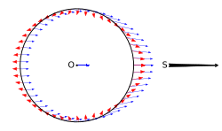
Diagram showing a circle with closely spaced arrows pointing away from the reader on the left and right sides, while pointing towards the user on the top and bottom.

理論上の単純なモデルでは、月がある方向にあるとき、その直下と正反対の地点で満潮となります。
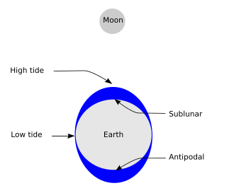
Simplified schematic of only the lunar portion of Earth's tides, showing (exaggerated) high tides at the sublunar point and its antipode for the hypothetical case of an ocean of constant depth without land, and on the assumption that Earth is not rotating; otherwise there is a lag angle. Solar tides not shown.

しかし、現実には地球が自転しているため、海水の盛り上がりは月の位置から少し前方にずれて現れます。この現象をラグ角と呼び、これが原因で満潮のタイミングは毎日少しずつずれていきます。
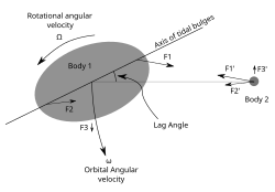
Earth's rotation drags the position of the tidal bulge ahead of the position directly under the Moon showing the lag angle.

太陽の影響と潮汐の変動

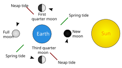
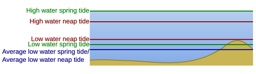
月だけでなく太陽も潮汐に影響を与えます。太陽は月よりもはるかに巨大ですが、地球からの距離が遠いため、潮汐力としての影響は月の約半分程度です。月と太陽の相対的な位置関係によって、潮位の差(潮差)が大きく変化します。

  • 大潮(Spring Tide): 新月や満月のときのように、太陽・地球・月がほぼ一直線に並ぶと、両者の引力が合わさり、潮差が最大になります。
  • 小潮(Neap Tide): 上弦や下弦のときのように、太陽と月が地球に対して直角に位置すると、引力が打ち消し合い、潮差が最小になります。
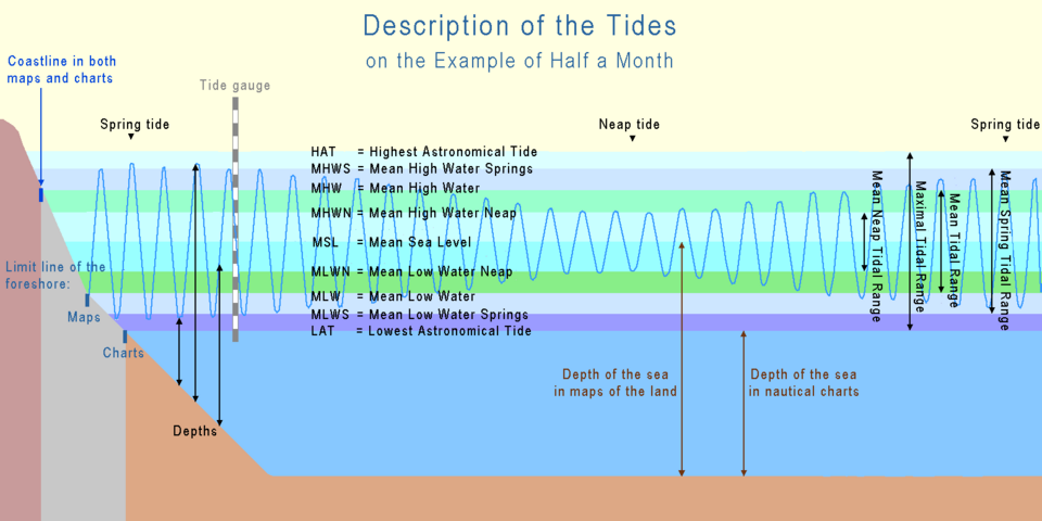
Illustration by the course of half a month
Spring tide: the Sun, moon, and earth form a straight line. Neap tide: the Sun, moon, and earth form a right angle.

地域による潮汐パターンの違い

理論上のモデルでは世界中で一斉に潮が満ち引きするように見えますが、実際には複雑な要因が絡み合っています。海岸線の向き、大陸棚の広さ、海盆の形状、そして水深(深浅)などが影響し、地域によって満潮・干潮の回数やタイミングが異なります。
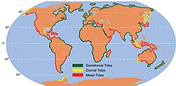
World map showing the location of diurnal, semi-diurnal, and mixed semi-diurnal tides. The European and African west coasts are exclusively semi-diurnal, and North America's West coast is mixed semi-diurnal, but elsewhere the different patterns are highly intermixed, although a given pattern may cover 200–2,000 kilometres (120–1,240 mi).

例えば、ある地域では月が南中したタイミングで満潮を迎えますが、多くの場所では位相のずれが生じています。
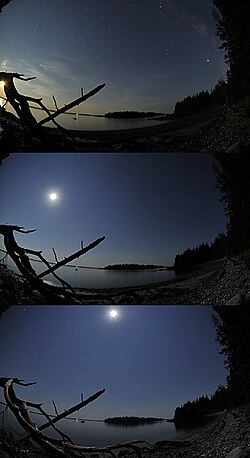
In Maine (U.S.), low tide occurs roughly at moonrise and high tide with a high Moon, corresponding to the simple gravity model of two tidal bulges; at most places however, the Moon and tides have a phase shift.

起潮点と潮汐波の伝播

海洋における潮汐は、巨大な波として伝播します。この波が回転するように動く中心点があり、これを起潮点(Amphidromic point)と呼びます。起潮点では潮位の変化がほとんどなく、そこから離れるほど潮差が大きくなる傾向があります。北半球では一般的に反時計回りに、南半球では時計回りに潮汐波が移動します。
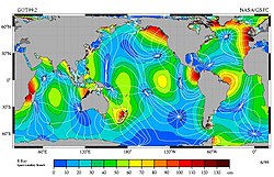
Map showing relative tidal magnitudes of different ocean areas

潮汐の観測と実用的利用

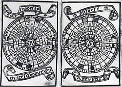
潮汐の正確な把握は、古くから航海術において不可欠でした。16世紀の記録には、月の満ち欠けに基づいた潮汐図が存在しており、経験的な観測が行われていたことがわかります。
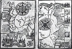
Brouscon's Almanach of 1546: Compass bearings of high waters in the Bay of Biscay (left) and the coast from Brittany to Dover (right).
Brouscon's Almanach of 1546: Tidal diagrams "according to the age of the moon".

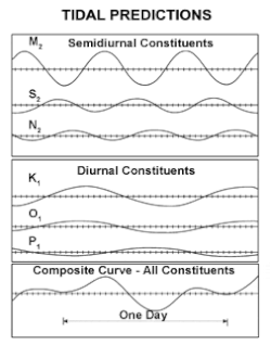
現代では、潮位計などの観測機器を用いて精密なデータが収集され、複雑な数学的成分(分潮)を合成することで、精度の高い潮汐予報が行われています。
A regular water level chart
Graph showing one line each for M 2, S 2, N 2, K 1, O 1, P 1, and one for their summation, with the X axis spanning slightly more than a single day

これらのデータは、船舶の安全な入出港や、干潮時にのみ現れる地形の調査、さらには潮汐発電などの再生可能エネルギーへの活用に利用されています。
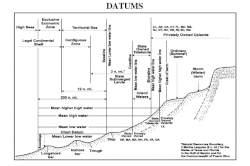
Chart illustrating that tidal heights enter in calculations of legally significant data such as boundary lines between the high seas and territorial waters. Chart shows an exemplar coastline, identifying bottom features such as longshore bar and berms, tidal heights such as mean higher high water, and distances from shore such as the 12 mile limit.
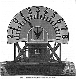
Tidal Indicator, Delaware River, Delaware, c. 1897. At the time shown in the figure, the tide is 1+1⁄4 feet above mean low water and is still falling, as indicated by pointing of the arrow. Indicator is powered by system of pulleys, cables and a float. (Report Of The Superintendent Of The Coast & Geodetic Survey Showing The Progress Of The Work During The Fiscal Year Ending With June 1897 (p. 483))

潮汐がもたらす環境への影響

潮汐は生物の生存戦略にも深く関わっています。満潮と干潮の間にさらされる潮間帯では、生物が過酷な環境に適応した独特の帯状分布(ゾーニング)が見られます。
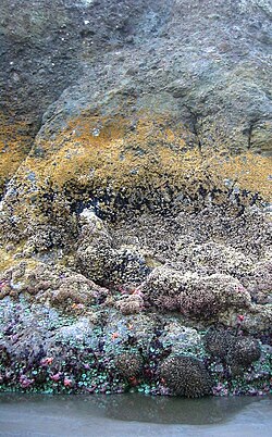
Photo of partially submerged rock showing horizontal bands of different color and texture, where each band represents a different fraction of time spent submerged

また、潮汐による海水の出入りは、河口域の栄養塩の循環を促進し、豊かな生態系を維持する役割を果たしています。
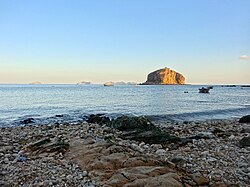
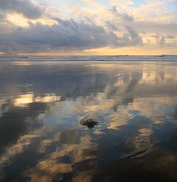
Low tide at Bangchuidao scenic area, Dalian, Liaoning Province, China
Low tide at Ocean Beach in San Francisco, California, U.S.
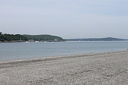
Low tide at Bar Harbor, Maine, U.S. (2014)
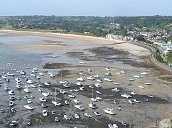
The harbour of Gorey, Jersey, falls dry at low tide.

潮汐現象の多様な形態

潮汐の現れ方は場所によって千差万別です。ある場所では1日に2回満潮となる「半日周潮」が見られ、別の場所では1回のみの「日周潮」が見られます。また、地形の影響で潮位の変動が激しくなるケースもあります。
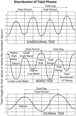
Three graphs. The first shows the twice-daily rising and falling tide pattern with nearly regular high and low elevations. The second shows the much more variable high and low tides that form a "mixed tide". The third shows the day-long period of a diurnal tide.

例えば、クック海峡のような狭い海域では、南北で潮汐のパターンが異なる現象が観察されます。
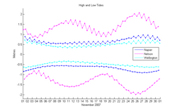
Graph showing 6 lines with two lines for each of three cities. Nelson has two monthly spring tides, while Napier and Wellington each have one.

さらに、海面だけでなく、海洋内部で発生する「内部潮汐」や、大気による「大気潮汐」、さらには地球の地殻自体がわずかに変動する「地球潮汐」など、潮汐現象は宇宙規模の広がりを持っています。

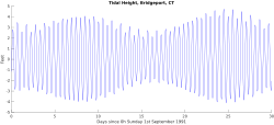
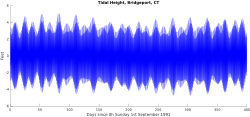
潮位の変動を長期的に観察すると、数時間単位の周期から、数十年単位の変動まで、多様な時間スケールでの変化が確認できます。
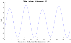
Graph with a single line rising and falling between 4 peaks around 3 and four valleys around −3
Graph with a single line showing tidal peaks and valleys gradually cycling between higher highs and lower highs over a 14-day period
Graph showing with a single line showing only a minimal annual tidal fluctuation

潮汐のまとめ

潮汐の主要メカニズムと分類
項目 大潮 (Spring Tide) 小潮 (Neap Tide)
天体の配置 太陽・地球・月が一直線 太陽と月が直角に位置
引力の関係 太陽と月の引力が強め合う 太陽と月の引力が打ち消し合う
潮位の差 (潮差) 最大になる 最小になる
発生タイミング 新月および満月付近 上弦および下弦付近

Frequently Asked Questions

なぜ満潮と干潮は1日に2回起こるのですか?

月による引力で地球の海水が月の方向へ引き寄せられるだけでなく、地球の反対側でも遠心力などの影響で海水が盛り上がるため、地球上に2つの「潮汐膨らみ」が同時に形成されます。地球が自転してこの2つの盛り上がりを通過するため、1日に約2回の満潮が訪れます。

大潮と小潮の違いは何ですか?

大潮は、太陽と月の引力が同じ方向に働くため、海面の盛り上がりが大きくなり、満潮位が高く干潮位が低くなる現象です。一方、小潮は太陽と月の引力が互いに打ち消し合う方向に働くため、潮位の変化が小さくなります。

潮汐は世界中で同時に起こりますか?

いいえ、同時に起こりません。海水の移動には時間がかかるため、また海岸線の形状や水深などの地形的要因によって、潮汐波の伝わり方が異なります。そのため、地域ごとに満潮・干潮のタイミングにずれが生じます。

潮汐以外に海面を変動させる要因はありますか?

はい。気圧の変化や強い風による「気象潮」と呼ばれる現象があります。低気圧が通過すると海面が吸い上げられて潮位が上がり、強風が海水を岸側に押し寄せると、天文的な潮汐とは別に潮位が変動することがあります。

起潮点とはどのような場所ですか?

潮汐波が回転するように伝播する際、その中心となる地点のことです。この点では理論的に潮位の変化がゼロとなり、そこから離れるほど潮位の変動幅(潮差)が大きくなります。