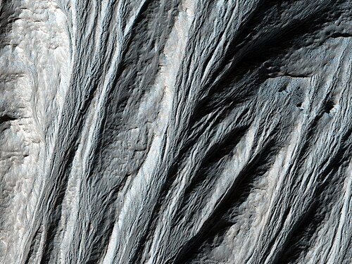
火星の表面には、地球の浸食地形に非常によく似たガリー(小峡谷)と呼ばれる細い溝状のネットワークが点在しています。これらの地形は、急峻な斜面やクレーターの壁面に多く見られ、火星の過去および現在の環境を知るための重要な手がかりとなっています。
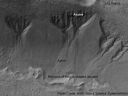
ガリーの多くは、上部の樹枝状に広がった「アルコーブ(窪地)」から始まり、一本の切り込みのある「チャネル(水路)」を経て、底部に扇状の「エプロン(堆積地)」を形成するという、砂時計のような独特の形状をしています。これらの地形にはクレーターがほとんど見られないため、地質学的に非常に新しい時代に形成されたと考えられています。
また、砂丘の斜面に刻まれた特殊なガリーも確認されており、これらは季節的に変化する動的な地形であると考えられています。
Key Facts
- 形状の特徴:アルコーブ、チャネル、エプロンの3つの部位からなる砂時計型。
- 分布:南北両半球の緯度30度以北・以南に多く、特に南半球に集中している。
- 形成要因の説:かつての液状の水による浸食説と、近年の二酸化炭素(ドライアイス)による流動説がある。
- 規模:CTXカメラの解析により、数万本に及ぶ個別のガリーが存在することが判明している。
- 時間軸:過去200万年以内の気候変動が形成に関与した可能性が指摘されている。
ガリーの分布と地理的特性
火星のガリーは惑星全体に均一に存在するわけではなく、特定の地域に限定して分布しています。北半球ではアルカディア平原、テンペテラ、アシダリア平原、ユートピア平原などで確認されています。一方、南半球ではアルギュレ盆地の北縁やノアキステラ北部、ヘラス盆地の流出チャネル沿いに高い密度で集中しています。
分布の傾向として、多くのガリーが極方向を向いた斜面に形成されており、特に南緯30度から44度の範囲で顕著です。ただし、一部の研究ではあらゆる方向の斜面でガリーが形成されていることも報告されています。
形成メカニズムを巡る科学的論争
ガリーがどのようにして作られたのかについては、長年議論が続いています。初期の研究では、地下水の湧出や表面を流れる液状の水が主因であると考えられていました。特に、エプロン部分の体積がチャネル部分に比べて少ないことから、かつて含まれていた氷や水が消失したためではないかという推論が立てられています。
しかし、近年の観測データは異なる視点を提供しています。現在の火星環境では液状の水が安定して存在することは困難であり、代わりに二酸化炭素の氷(ドライアイス)が昇華し、それによって誘発された堆積物の流れがガリーを刻んでいるという説が有力視されています。
また、火星の自転軸の傾き(地軸傾斜角)が変化することで気候が変動し、約40万年前から200万年前の間に氷が融解しやすい環境が整い、それがガリー形成を促進したという説も提唱されています。
火星ガリーの概要まとめ
| 項目 | 詳細内容 |
|---|---|
| 構成要素 | アルコーブ(上部)、チャネル(中間)、エプロン(下部) |
| 主な分布域 | 中・高緯度地域(特に南半球の極方向斜面) |
| 推定年代 | 比較的若い(クレーターが少ないため) |
| 候補となる形成物質 | 液状の水、水氷、二酸化炭素氷(ドライアイス) |
| 観測手段 | Mars Global Surveyor, MRO (HiRISE, CTX) など |
Frequently Asked Questions
火星のガリーは現在も形成されていますか?
はい。特に砂丘に見られる線状のガリーなどは、季節的な変化を伴う再帰的な特徴を持っており、現在も活動していると考えられています。
なぜ「水」ではなく「ドライアイス」説が注目されているのですか?
現在の火星の極めて低い気圧と温度では、液状の水が表面に長時間留まることが難しいためです。二酸化炭素の氷の挙動の方が、現在の環境条件と整合性が高いと考えられています。
ガリーの形状から何が分かりますか?
砂時計のような形状や、堆積物の量、およびそれらが刻まれている地層(マントル)の状態を分析することで、過去にどのような物質がどのような速度で流れたかを推定できます。
ガリーは火星のどこに一番多くありますか?
統計的に南半球に多く分布しており、特に南緯30度から44度の極方向を向いた急斜面やクレーターの壁面に集中して見られます。
References
- Malin, M.; Edgett, K. (2000). "Evidence for recent groundwater seepage and surface runoff on Mars". Science. 288 (5475): 2330–2335. :2000Sci...288.2330M. :10.1126/science.288.5475.2330. 10875910.
- G. Jouannic; J. Gargani; F. Costard; G. Ori; C. Marmo; F. Schmidt; A. Lucas (2012). "Morphological and mechanical characterization of gullies in a periglacial environment: The case of the Russell crater dune (Mars)". Planetary and Space Science. 71 (1): 38–54. :2012P&SS...71...38J. :10.1016/j.pss.2012.07.005.
- Pasquon, Kelly; Gargani, Julien; Massé, Marion; Conway, Susan J. (August 2016). "Present-day formation and seasonal evolution of linear dune gullies on Mars". Icarus. 274: 195–210. :2016Icar..274..195P. :10.1016/j.icarus.2016.03.024.
- Edgett, K.; et al. (2003). "Polar-and middle-latitude martian gullies: A view from MGS MOC after 2 Mars years in the mapping orbit" (PDF). Lunar Planet. Sci. 34. Abstract 1038. :2003LPI....34.1038E.
- Dickson, James L.; Head, James W.; Kreslavsky, Mikhail (June 2007). "Martian gullies in the southern mid-latitudes of Mars: Evidence for climate-controlled formation of young fluvial features based upon local and global topography". Icarus. 188 (2): 315–323. :2007Icar..188..315D. :10.1016/j.icarus.2006.11.020.
- Heldmann, J; Carlsson, E; Johansson, H; Mellon, M; Toon, O (2007). "Observations of martian gullies and constraints on potential formation mechanismsII. The northern hemisphere". Icarus. 188 (2): 324–344. :2007Icar..188..324H. :10.1016/j.icarus.2006.12.010.
- Harrison, T. N.; Osinski, G. R.; Tornabene, L. L. (2014). Global Documentation of Gullies with the Mars Reconnaissance Orbiter Context Camera (CTX) and Implications for Their Formation. 45th Annual Lunar and Planetary Science Conference. p. 2124. :2014LPI....45.2124H.
- Luu, K.; Gulick, V. C.; Glines, N. H. (2018). Gully Formation on the Northwestern Slope of Palikir Crater, Mars. 49th Annual Lunar and Planetary Science Conference. p. 2650. :2018LPI....49.2650L.
- Hamid, S. H.; Gulick, V. C. (2018). Geomorphological Analysis of Gullies Along Western Slopes of Palikir Crater. 49th Annual Lunar and Planetary Science Conference. p. 2644. :2018LPI....49.2644H.
- Paladino, T. P.; Gulick, V. G.; Glines, N. G. (2018). Insights into the Formation of Gullies in Asimov Crater, Mars. 49th Annual Lunar and Planetary Science Conference. p. 2889. :2018LPI....49.2889P.
📸 フォトギャラリー