地球の隣にある赤い惑星、火星。その表面や内部の構造、そして形成過程を研究する学問が火星地質学です。惑星科学の分野では、地質学(Geology)という言葉を広義に用い、岩石の組成や物理的プロセス、地図作成までを含む包括的な研究を指します。また、ギリシャ語で火星を意味する「アレス(Arēs)」に由来して、アレオロジー(Areology)という独自の呼称で呼ばれることもあります。
火星の地質を理解することは、単に岩石を調べることではなく、この惑星がかつてどのような環境にあり、どのように変化してきたかという壮大な歴史を紐解くことに他なりません。
![Generalised geological map of Mars[1]](/images/7e/cc/7ecc9290fd3632730e64c5dfdf957054ec5f057e117bb8a8f7680e8a0cc4144e.jpg)
Key Facts
- 内部構造:最新の調査により、地殻の下に放射性マグマの海が存在することが示唆されている。
- 地表の特徴:北半球の低地と南半球の高地という明確な「地殻二分性」を持つ。
- 火山活動:タルシスやエリシウムといった巨大な火山地帯が存在し、かつてはケイ質火山活動も活発だった可能性がある。
- 土壌組成:玄武岩質の風化した土壌が主であり、長石や輝石、かんらん石などの鉱物が検出されている。
- 水と氷:極冠に氷が存在し、過去には地下水や地表水が地形を形成した痕跡が数多く見られる。
火星の内部構造と組成
火星の深部を探るため、NASAの探査機「インサイト(InSight)」が重要な役割を果たしました。2018年に着陸したこのミッションは、高感度な地震計を用いて内部の3次元構造をマッピングすることを目指しました。その成果として、2023年には地殻の下に放射性マグマの海が存在するという驚くべき報告がなされました。これにより、火星の核(コア)の大きさが従来の推定よりも小さい理由が説明されつつあります。
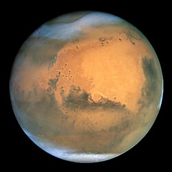
ダイナミックな地表地形
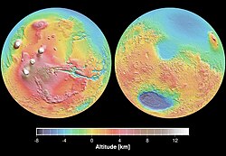
南北の地殻二分性
火星の最も顕著な特徴の一つが、北半球と南半球で地形が大きく異なる「地殻二分性」です。北側は比較的平坦で低いのに対し、南側はクレーターが多く標高が高い高地となっています。
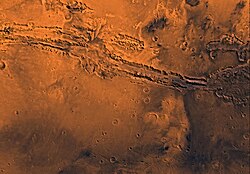
巨大火山地帯と峡谷
火星には、太陽系最大級の火山が集まるタルシス地域と、エリシウム地域という2つの大きな火山省が存在します。また、赤道付近には「マリネリス峡谷」という、地球上のどの峡谷をも凌駕する巨大な裂け目のような地形が広がっています。
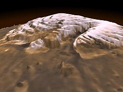
極冠と氷の分布
火星の両極には氷のキャップ(極冠)が存在します。北極のプラヌム・ボレウムなどの地域では、高原の上に薄い氷の層が広がっていることが分かっています。
地質学的歴史と鉱物分析
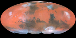
火星の表面は、アルベド(反射率)の違いによってさまざまな特徴が見て取れます。明るい色の地域(タルシス、アラビア、エリシウムなど)と暗い色の地域(アシダリア平原やシルティス・メジャーなど)が混在しており、これらは地質学的な組成の違いを反映しています。
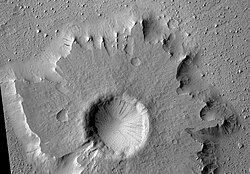
また、地表には衝撃クレーターが数多く存在し、一部には「ペデスタル・クレーター」のような特殊な形態を持つものも見つかっています。
探査車「キュリオシティ」による詳細な分析では、火星の土壌に長石、輝石、かんらん石が含まれていることが判明しました。これは地球のハワイ火山に見られる「風化した玄武岩質土壌」に似た組成です。さらに、ゲールクレーターでトリディマイト(三晶石)が発見されたことで、かつての火山活動においてケイ質火山が予想以上に重要な役割を果たしていた可能性が浮上しました。
![First X-ray diffraction image of Martian soil - CheMin analysis reveals feldspar, pyroxenes, olivine and more (Curiosity rover at "Rocknest").[63]](/images/3b/08/3b08b4fdcf4ca67376e727d3e1990d90306016f5a51b165f7dd8f2ea4e43a41a.jpg)
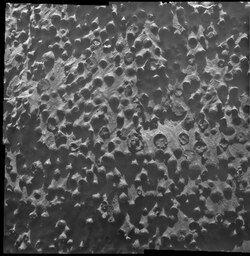
さらに、探査車「オポチュニティ」は、直径約3mmの小さな球状の岩石を多数発見しており、これらは過去の水環境を示唆する重要な手がかりとなっています。
火星地質のまとめ
| カテゴリー | 主な特徴・名称 | 科学的意義 |
|---|---|---|
| 内部構造 | 放射性マグマの海 | 核のサイズと熱進化の解明 |
| 主要地形 | タルシス・エリシウム | 大規模な火山活動の証拠 |
| 特異地形 | マリネリス峡谷 | 地殻の変動と構造的ストレス |
| 土壌組成 | 玄武岩質(長石・輝石等) | 地球の火山地帯との類似性 |
| 水・氷 | 極冠・地下水痕跡 | 過去の居住可能性の検討 |
Frequently Asked Questions
火星の地質学を「アレオロジー」と呼ぶのはなぜですか?
ギリシャ語で火星を意味する「アレス(Arēs)」と、学問を意味する接尾辞を組み合わせた造語だからです。主にSF作品や一部の専門団体で使用されています。
火星の土壌は地球のどこに似ていますか?
キュリオシティの分析によると、ハワイの火山に見られる「風化した玄武岩質土壌」に非常に近い組成を持っていることが分かっています。
火星の内部には何があると考えられていますか?
インサイト探査機のデータに基づき、地殻の下に放射性物質を含むマグマの海が存在していると考えられています。
火星の表面にある「二分性」とは何ですか?
北半球が低く平坦な地帯であるのに対し、南半球が高くクレーターが多いという、惑星規模での地形的な不均衡のことを指します。
火星に火山活動があった証拠はありますか?
はい。タルシスやエリシウムに存在する巨大な火山群や、地表から検出されたトリディマイトなどの鉱物が、激しい火山活動の歴史を証明しています。
References
- P. Zasada (2013) Generalised Geological Map of Mars, 1:140.000.000, Source Link.
- Greeley, Ronald (1993). Planetary landscapes (2nd ed.). New York: Chapman & Hall. p. 1. .
- "World Wide Words: Areologist". World Wide Words. Retrieved October 11, 2017.
- "The Areological Society". The Areological Society. Archived from the original on 2021-11-07. Retrieved 2021-11-07.
- Tanaka, Kenneth L.; Skinner, James A. Jr.; Dohm, James M.; Irwin, Rossman P., III; Kolb, Eric J.; Fortezzo, Corey M.; Platz, Thomas; Michael, Gregory G.; Hare, Trent M. (July 14, 2014). "Geologic Map of Mars - 2014". . Retrieved July 22, 2014.
{{}}: CS1 maint: multiple names: authors list () - Krisch, Joshua A. (July 22, 2014). "Brand New Look at the Face of Mars". . Retrieved July 22, 2014.
- Staff (July 14, 2014). "Mars - Geologic map - Video (00:56)". . Retrieved July 22, 2014.
- Chang, Kenneth (30 April 2018). "Mars InSight: NASA's Journey Into the Red Planet's Deepest Mysteries". . Retrieved 30 April 2018.
- Chang, Kenneth (5 May 2018). "NASA's InSight Launches for Six-Month Journey to Mars". . Retrieved 5 May 2018.
- InSight lander completes seismometer deployment on Mars. Stephen Clark, Space Flight Now. 4 February 2019.
📸 フォトギャラリー