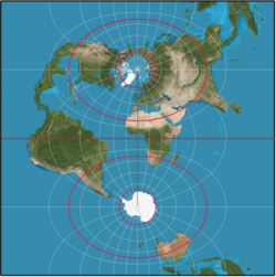
Earth model with circles of latitude in black and indications of the North Pole, Equator, and the northern and southern hemispheres.
← ホームへ戻る
緯度経度測地学WGS84地球楕円体

緯度と経度の仕組み:地球の形状と測地学的な座標系

🗓 2026年8月10日

私たちが地図やGPSで日常的に利用している「緯度」と「経度」は、単なる数字の羅列ではなく、地球という複雑な立体を数学的に定義したものです。地球を単純な球体として捉えるか、あるいは回転による歪みを考慮した楕円体として捉えるかによって、算出される位置情報は微妙に異なります。本記事では、測地学(Geodesy)の視点から、地球上の位置を特定するための基礎概念と、高度な座標系の仕組みを解説します。

まず基本となるのが、地球の回転軸と赤道を基準とした経緯線(Graticule)です。北極と南極を結ぶ垂直な線が経線(Longitude)であり、赤道に平行な円が緯線(Latitude)となります。これにより、地球上のあらゆる地点を角度で表現することが可能になります。
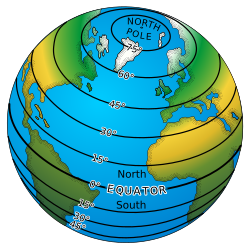
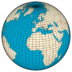
Earth model with circles of latitude in black and indications of the North Pole, Equator, and the northern and southern hemispheres.
Earth's graticule. The vertical lines from pole to pole are lines of constant longitude, or meridians. The circles parallel to the equator are lines of constant latitude, or parallels. The graticule shows the latitude and longitude of points on the surface. In this example meridians are spaced at 6° intervals and parallels at 4° intervals.

Key Facts

  • 緯度(Latitude)は赤道からの南北の角度で、北緯90°から南緯90°までで定義される。
  • 経度(Longitude)は本初子午線からの東西の角度で定義される。
  • 地球は完全な球ではなく、自転の影響で赤道方向に膨らんだ回転楕円体に近い形状をしている。
  • 現代のGPSなどで標準的に利用されている参照楕円体はWGS84である。
  • 使用する楕円体(データム)が異なると、同じ座標値でも実際の地上位置が数百メートルずれることがある。

地球をモデル化する:球体から楕円体へ

単純な球体モデル

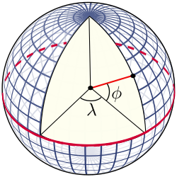
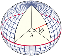
概念的な理解において、地球はしばしば半径約6,371kmの球体として扱われます。このモデルでは、緯度は赤道面と地点を結ぶ半径ベクトルとのなす角として定義されます。また、特定の緯線には重要な名称があり、北回帰線(北緯23°26′)や北極圏(北緯66°34′)などがこれにあたります。
ภาพประกอบบทความ
A perspective view of the Earth showing how latitude ( ϕ {\displaystyle \phi } ) and longitude ( λ {\displaystyle \lambda } ) are defined on a spherical model. The graticule spacing is 10 degrees.

回転楕円体モデルの必要性

しかし、実際の地球は自転による遠心力のため、赤道半径が極半径よりも約21km長い「扁平な」形状をしています。このため、より精密な位置測定には参照楕円体(Reference Ellipsoid)というモデルが用いられます。楕円体モデルでは、表面の法線(面に垂直な線)が必ずしも地球の中心を通らないため、「測地緯度」と「地心緯度」という異なる概念が登場します。
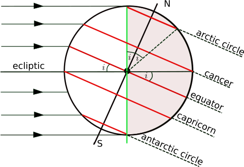
The orientation of the Earth at the December solstice
ภาพประกอบบทความ
ภาพประกอบบทความ
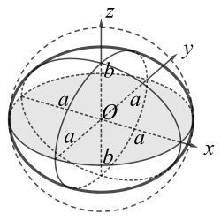
A sphere of radius a compressed along the z axis to form an oblate ellipsoid of revolution.

測地緯度と地心緯度の違い

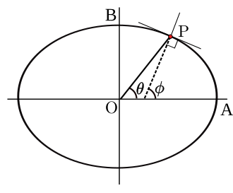
測地緯度(Geodetic Latitude)とは、楕円体表面における法線と赤道面とのなす角のことです。一方、地心緯度(Geocentric Latitude)は、地球の中心と地点を結ぶ線が赤道面となす角を指します。この2つの差は最大で約11.5分(約1/5度)に達し、特に中緯度地域で顕著になります。
The definition of geodetic latitude ( ϕ {\displaystyle \phi } ) and longitude ( λ {\displaystyle \lambda } ) on an ellipsoid. The normal to the surface does not pass through the centre, except at the equator and at the poles.
The definition of geodetic latitude (ϕ) and geocentric latitude (θ)

座標系とデータムの重要性

位置を正確に特定するには、どの楕円体モデル(データム)を採用しているかを明示する必要があります。例えば、世界的に普及しているWGS84と、欧州でかつて使われていたED50では、同じ座標を指定しても地上では100メートル以上の誤差が生じることがあります。これは、各データムが特定の地域に最適化して設計されていた歴史的背景があるためです。
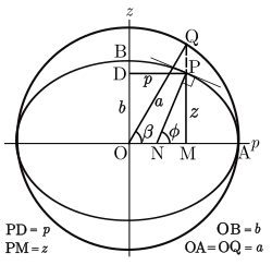
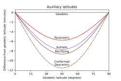
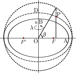
Definition of the parametric latitude (β) on the ellipsoid
inline

高度な座標表現

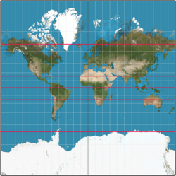
測地学では、用途に応じてさまざまな補助的な緯度の定義が使い分けられます。面積を等しく保つための「等面積緯度」や、地図投影法(メルカトル図法など)で利用される「等角緯度(Conformal Latitude)」などがあり、これらは計算を簡略化したり、地図上の歪みを制御したりするために不可欠です。
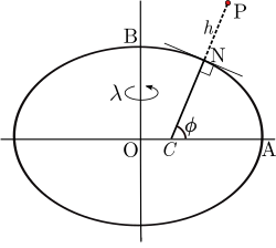
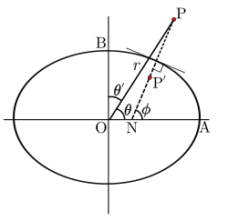
Geodetic coordinates P(ɸ,λ,h)
Geocentric coordinate related to spherical polar coordinates P(r,θ′,λ)
Ellipsoidal coordinates P(u,β,λ)

ジオイドと物理的な高さ

さらに、地球の重力場を考慮した平均海面を延長した仮想的な面をジオイド(Geoid)と呼びます。実際の地表は、このジオイド面と、数学的なモデルである楕円体面の間で複雑に変動しています。
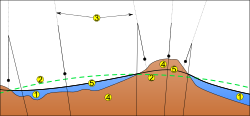
OceanEllipsoidLocal plumb lineContinentGeoid

緯度1度あたりの距離

地球を球体と仮定した場合、緯度1度の長さは約111.2km(60海里)でほぼ一定です。しかし、楕円体モデル(WGS84)では、地球の扁平さの影響で、赤道付近よりも極地方の方が緯度1度あたりの距離がわずかに長くなります。一方で、経度1度あたりの距離は、赤道で最大となり、極点に向かうにつれて0kmまで減少します。

WGS84楕円体における緯度・経度1度あたりの距離(概算)
緯度 緯度1度の距離 (Δlat) 経度1度の距離 (Δlong)
0° (赤道) 110.574 km 111.320 km
30° 110.852 km 96.486 km
45° 111.132 km 78.847 km
60° 111.412 km 55.800 km
90° (極点) 111.694 km 0.000 km

Frequently Asked Questions

なぜGPSではWGS84というモデルが使われているのですか?

WGS84は地球の重心を中心とし、自転軸に合わせた世界共通の参照楕円体だからです。地域ごとの最適化ではなく、地球全体をカバーする標準的なモデルであるため、世界中どこでも一貫した座標系で位置を特定できます。

測地緯度と地心緯度は具体的にどう違うのですか?

測地緯度は「地表で垂直に立てた線」が赤道面となす角であり、地心緯度は「地球の中心から見た線」が赤道面となす角です。地球が完全な球体であれば一致しますが、楕円体であるため、中心を通らない法線を用いる測地緯度の方が一般的です。

緯度1度の距離はどこでも同じではありませんか?

厳密には異なります。地球は極方向に少し潰れた形状をしているため、極に近いほど表面の曲率が緩やかになり、緯度1度あたりの実際の距離は赤道付近よりもわずかに長くなります。

データム(参照楕円体)が違うとどのような問題が起きますか?

同じ緯度・経度の数値であっても、参照する楕円体の形状や中心位置が異なると、地図上の地点が実際の位置から数十メートルから数百メートルずれて表示されることがあります。これを解消するために「データム変換」という計算が行われます。

References

  1. The value of this angle today is 23°26′09.0″ (or 23.43583°). This figure is provided by .
  2. An elementary calculation involves differentiation to find the maximum difference of the geodetic and geocentric latitudes.

📸 フォトギャラリー

Earth model with circles of latitude in black and indications of the North Pole, Equator, and the northern and southern hemispheres.
Earth's graticule. The vertical lines from pole to pole are lines of constant longitude, or meridians. The circles parallel to the equator are lines of constant latitude, or parallels. The graticule shows the latitude and longitude of points on the surface. In this example meridians are spaced at 6° intervals and parallels at 4° intervals.
ภาพประกอบบทความ
A perspective view of the Earth showing how latitude ( ϕ {\displaystyle \phi } ) and longitude ( λ {\displaystyle \lambda } ) are defined on a spherical model. The graticule spacing is 10 degrees.
The orientation of the Earth at the December solstice
ภาพประกอบบทความ
ภาพประกอบบทความ
A sphere of radius a compressed along the z axis to form an oblate ellipsoid of revolution.
The definition of geodetic latitude ( ϕ {\displaystyle \phi } ) and longitude ( λ {\displaystyle \lambda } ) on an ellipsoid. The normal to the surface does not pass through the centre, except at the equator and at the poles.
The definition of geodetic latitude (ϕ) and geocentric latitude (θ)
Definition of the parametric latitude (β) on the ellipsoid
inline
Geodetic coordinates P(ɸ,λ,h)
Geocentric coordinate related to spherical polar coordinates P(r,θ′,λ)
Ellipsoidal coordinates P(u,β,λ)
OceanEllipsoidLocal plumb lineContinentGeoid