A view from the top of the Great Escarpment in the Karoo National Park near Beaufort West, looking south across the plains of the Lower Karoo: Note the remnants and extent of the former central plateau on the plain below the escarpment (see diagram on the right). Also note the dolerite sills which top the escarpment and mountains in the middle distance, giving these structures their characteristic flat-topped appearance.
← ホームへ戻る
カルー南アフリカ地質学カルー超層群グレート・エスカープメント

カルー地方の地質と生態系南アフリカの広大な半乾燥地帯

🗓 2026年8月10日

南アフリカの内陸部に広がるカルー(Karoo)は、かつて探検家たちが猛烈な暑さと寒さ、そして極端な干ばつと洪水が繰り返される「恐ろしい場所」として恐れた地域です。しかし、その過酷な環境こそが、地球の歴史を物語る貴重な地層と、独自の進化を遂げた動植物を育んできました。現在は地下水の活用により、羊の放牧や定住が可能な地域へと変貌しています。

主要な事実(Key Facts)

  • 地理的区分:広大な「グレート・カルー」と、山脈に挟まれた狭い谷の「クライン・カルー」に分かれる。
  • 地質学的価値:カルー超層群と呼ばれる厚い堆積岩層があり、古生物学的に重要な化石が豊富に産出する。
  • 気候的特徴:年間降水量が50〜250mmと極めて少ないが、地下水が生活と農業を支えている。
  • 天文学の聖地:低光害、高標高、地殻変動の少なさから、世界最大級の光学望遠鏡などが設置されている。

カルーの地理的構造と区分

カルー地方は、大きく分けて「グレート・カルー」と「クライン・カルー」の2つの領域に分類されます。グレート・カルーは南西側のケープフォールド山脈を境界とし、北方向へは緩やかに乾燥地帯へと溶け込んでいます。この地域はさらに、標高1,200〜1,500m以上の「アッパー・カルー」と、その下の平原である「ロワー・カルー」に分かれています。

この2つの領域を分かつのがグレート・エスカープメント(大断崖)です。この断崖は、浸食に強いドレライト(粗粒玄武岩)の岩層が頂部に位置しているため、特徴的な平坦な頂上を持つ景観を作り出しています。
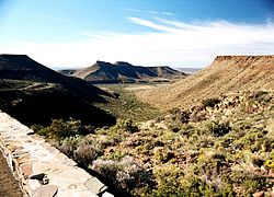
A view from the top of the Great Escarpment in the Karoo National Park near Beaufort West, looking south across the plains of the Lower Karoo: Note the remnants and extent of the former central plateau on the plain below the escarpment (see diagram on the right). Also note the dolerite sills which top the escarpment and mountains in the middle distance, giving these structures their characteristic flat-topped appearance.

断崖の浸食が進むにつれ、かつての高原部分が孤立して残った「島」のような地形が平原に見られます。これがカルー地方のダイナミックな地形的特徴です。

A stylized illustration of the Great Escarpment, based particularly on its appearance in the Great Karoo, where thick erosion resistant dolerite sills (see below; represented here by the thick black lines. The thinner dolerite sills are not drawn in this diagram to avoid clutter) generally form the upper, sharp edge of the escarpment. (In other parts of the escarpment, hard erosion-resistant geological layers similarly form the upper, abrupt edge.) Note the island remnants of the earlier extent of the plateau on the plain below the escarpment (the Lower Karoo), left behind as the escarpment has gradually eroded further inland.[12]

一方、クライン・カルーはスワルトベルク山脈とランゲベルク・アウテニクア山脈という2つの平行な山脈に挟まれた、全長約290km、幅40〜60kmの細長い谷状の地形をしています。特に山麓付近は水資源が豊富で、多くの町や集落が形成されています。
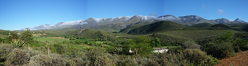
Farmlands along the well-watered, fertile foothills of the plus 2,000 m (6,600 ft) high Swartberg Mountains (in the background) along the northern strip of the Klein Karoo

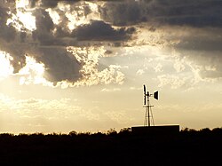
グレート・カルーの景観を象徴するのが、平らな頂上を持つ丘「カルー・コッピー(Karoo Koppies)」です。また、乾燥した大地で地下水を汲み上げるための風車(ウィンドポンプ)も、この地の象徴的な風景の一部となっています。

Flat-topped hills (called Karoo Koppies) are highly characteristic of the southern and southwestern Karoo landscape.
Sunset in the Great Karoo, near Sutherland, showing a multibladed windpump, which has made permanent settlement and farming possible in this thirsty land. These windpumps are as iconic of the Great Karoo as are the flat-topped Karoo Koppies.

地質学的歴史とカルー超層群

地質学的に見ると、この地域はカルー超層群と呼ばれる、約1億8,000万年前から3億1,000万年前の堆積岩および火成岩の層で構成されています。この層は南アフリカの国土の3分の2を覆い、地下8,000mにまで達する膨大な体積を持っています。
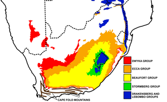
A schematic geological map of the outcrops (surface exposures) of the Karoo Supergroup rocks in Southern Africa: The location and approximate structure of the Cape Fold Mountains are also diagrammatically indicated for reference purposes.

カルーの形成は、約3億2,000万年前、当時のゴンドワナ大陸が南極付近に位置していた時代に始まりました。氷河から分離した氷山が泥を堆積させた「ドワイカ層」に始まり、その後、内海や湿地帯へと変化して石炭層を含む「エッカ層」、そして広大な平原に泥が堆積した「ボーフォート層」へと積み重なりました。

特にボーフォート層には、古代の爬虫類や両生類の化石が大量に含まれており、古生物学の世界で非常に高く評価されています。その後、激しい溶岩の噴出が起こり、地層の間にドレライトの岩脈(シル)が貫入しました。長い年月をかけて柔らかい堆積岩が浸食され、硬いドレライト層だけが残ったことで、前述の平坦な丘が形成されました。
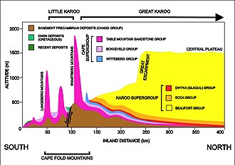
A diagrammatic 400 km north–south cross-section through the southern portion of the country at approximately 21° 30' E (i.e. near Calitzdorp in the Klein Karoo), showing the relationship between the Cape Fold Mountains (and their geological structure) and the geology of the Klein and Great Karoo, as well as the position of the Great Escarpment. The colour code for the Karoo rocks is the same as those used in the above diagram. The heavy black line flanked by opposing arrows is the fault that runs for nearly 300 km along the southern edge of the Swartberg Mountains. The Swartberg range owes some of its great height to upliftment along this fault line. The subsurface structures are not to scale.

生態系と野生動物の変遷

カルーの生物相は、西側の「サキュレント・カルー(多肉植物カルー)」と東側の「ナマ・カルー」という2つのバイオーム(生物群系)に分かれています。
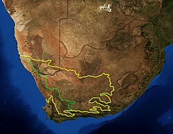
Two separate and independent Karoo biomes, or botanical regions, of South Africa bear the name Karoo: the Succulent Karoo to the west of green line, and the Nama Karoo to the east.

春になると、ナマクアランドなどの地域では色鮮やかな花々が咲き誇ります。

Spring flowers in Namaqualand

動物相に目を向けると、かつてはクアッガ(シマウマの近縁種)やスプリングボックなどのアンテロープが大量に生息していました。特にクアッガは温順で飼い慣らしやすかったため、狩猟の標的となり、1883年にアムステルダムの動物園で最後の一頭が死に絶えました。
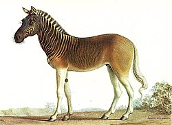
Painting of a quagga stallion in Louis XVI's menagerie at Versailles by Nicolas Marechal, 1793
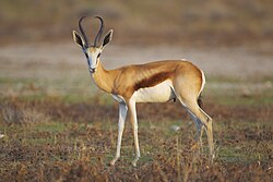
A springbok, one of Southern Africa's most well-known antelopes or gazelles

現在、大型の捕食者は減少しましたが、カラカルやジャッカル、猛禽類などが生息しています。また、クライン・カルーの乾燥した気候と豊富な水辺は、ダチョウの飼育に最適であり、かつては羽毛の輸出が盛んな産業となりました。

絶滅の危機に瀕したマウンテンゼブラについても、保護区での管理により個体数の回復が進んでいます。

天文学と近代史

アッパー・カルーにあるサザーランドなどの地域は、標高が高く、人工的な光がほとんどないため、天体観測に最適な環境です。ここでは南半球最大の光学望遠鏡である「サザン・アフリカン・ラージ・テレスコープ(SALT)」や、次世代の電波望遠鏡プロジェクト「スクエア・キロメートル・アレイ(SKA)」のアンテナが設置されています。地殻変動が極めて少ないことも、精密な観測を可能にする重要な要因です。

歴史的には、18世紀半ばに遊牧民であるトレックブーア(trekboers)がこの地に足を踏み入れ、過酷な環境の中で生活を切り拓きました。また、1899年から1902年にかけての第二次ボーア戦争では、この広大な土地を舞台にゲリラ戦が展開され、今でも鉄道沿いなどに当時の防衛拠点であるブロックハウスの跡が見られます。
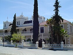
The Lord Milner Hotel in Matjiesfontein, in the Lower Karoo, next to the Matjiesfontein railway station, on the railway line from Cape Town to Johannesburg
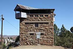
A blockhouse in the eastern Karoo

カルー地方の概要まとめ

カルー地方の主要データ
項目 グレート・カルー クライン・カルー
地形的特徴 広大な平原と大断崖(エスカープメント) 2つの山脈に挟まれた狭い谷
主な地質 カルー超層群(堆積岩・ドレライト) ケープフォールド山脈の構造
気候・水資源 極めて乾燥、地下水に依存 山麓付近は比較的潤いがある
象徴的な景観 カルー・コッピー、風車、天文台 ダチョウ農場、山岳風景

Frequently Asked Questions

カルー地方の「コッピー」とは何ですか?

カルー・コッピーとは、この地域に特有の平坦な頂上を持つ丘のことです。浸食に強いドレライト(火成岩)の層がキャップのように地層の上部に残ったため、このような形状になりました。

なぜカルー地方は天体観測に適しているのですか?

標高が高く空気が澄んでいることに加え、都市から離れているため人工的な光(光害)がほとんどないからです。さらに、地殻変動が極めて少なく、精密な望遠鏡を設置するのに理想的な地盤であるためです。

カルー超層群にはどのような化石が含まれていますか?

約3億年前から2億年前の、初期の爬虫類や両生類、そして初期の哺乳類に近いシナプシド類などの化石が豊富に含まれています。これらは地球上の生命進化の過程を解明する上で非常に重要な資料となっています。

クアッガとはどのような動物でしたか?

クアッガはシマウマの近縁種で、体の前半分にのみ縞模様があるのが特徴でした。非常に温順な性格でしたが、スポーツとしての狩猟により激減し、19世紀後半に絶滅しました。

カルー地方での生活を可能にした技術は何ですか?

19世紀後半に導入された「ウィンドポンプ(風車式ポンプ)」です。これにより、地表には水がない乾燥地帯でも、深い地下水を汲み上げることが可能になり、定住や羊の放牧が実現しました。

References

  1. Atlas of Southern Africa. (1984). p. 13, 98–106, 114–119. Reader's Digest Association, Cape Town
  2. "Definition of KAROO". www.merriam-webster.com. Retrieved 24 April 2026.
  3. "Karoo - Etymology, Origin & Meaning". etymonline. Retrieved 24 April 2026.
  4. "karoo". (online ed.). Oxford University Press. (Subscription or participating institution membership required.)
  5. "English – Kora index" (PDF). Archived from the original (PDF) on 17 August 2021. Retrieved 22 March 2025.
  6. Potgieter, D.J.; du Plessis, T.C. (1972). "Karoo". Standard Encyclopaedia of Southern Africa. Vol. 6. Cape Town: Nasou. pp. 306–307.
  7. Reader's Digest Illustrated Guide to Southern Africa (5 ed.). Cape Town: Reader's Digest Association of South Africa Pty. Ltd. 1993. pp. 78–89.
  8. Sahney, S.; Benton, M.J. (2008). "Recovery from the most profound mass extinction of all time". Proceedings of the Royal Society B: Biological Sciences. 275 (1636): 759–65. :10.1098/rspb.2007.1370.  2596898.  18198148.
  9. Palmer, E (1966). The Plains of Camdeboo. London: Fontana / Collins. pp. 12–13, 120, 126, 140–146.
  10. "Karoo". The New Encyclopædia Britannica Micropaedia. Vol. 6. Chicago: Encyclopædia Britannica Inc. 2007. p. 750.

📸 フォトギャラリー

A view from the top of the Great Escarpment in the Karoo National Park near Beaufort West, looking south across the plains of the Lower Karoo: Note the remnants and extent of the former central plateau on the plain below the escarpment (see diagram on the right). Also note the dolerite sills which top the escarpment and mountains in the middle distance, giving these structures their characteristic flat-topped appearance.
A stylized illustration of the Great Escarpment, based particularly on its appearance in the Great Karoo, where thick erosion resistant dolerite sills (see below; represented here by the thick black lines. The thinner dolerite sills are not drawn in this diagram to avoid clutter) generally form the upper, sharp edge of the escarpment. (In other parts of the escarpment, hard erosion-resistant geological layers similarly form the upper, abrupt edge.) Note the island remnants of the earlier extent of the plateau on the plain below the escarpment (the Lower Karoo), left behind as the escarpment has gradually eroded further inland.[12]
Farmlands along the well-watered, fertile foothills of the plus 2,000 m (6,600 ft) high Swartberg Mountains (in the background) along the northern strip of the Klein Karoo
A schematic geological map of the outcrops (surface exposures) of the Karoo Supergroup rocks in Southern Africa: The location and approximate structure of the Cape Fold Mountains are also diagrammatically indicated for reference purposes.
Flat-topped hills (called Karoo Koppies) are highly characteristic of the southern and southwestern Karoo landscape.
A diagrammatic 400 km north–south cross-section through the southern portion of the country at approximately 21° 30' E (i.e. near Calitzdorp in the Klein Karoo), showing the relationship between the Cape Fold Mountains (and their geological structure) and the geology of the Klein and Great Karoo, as well as the position of the Great Escarpment. The colour code for the Karoo rocks is the same as those used in the above diagram. The heavy black line flanked by opposing arrows is the fault that runs for nearly 300 km along the southern edge of the Swartberg Mountains. The Swartberg range owes some of its great height to upliftment along this fault line. The subsurface structures are not to scale.
Two separate and independent Karoo biomes, or botanical regions, of South Africa bear the name Karoo: the Succulent Karoo to the west of green line, and the Nama Karoo to the east.
Spring flowers in Namaqualand
Painting of a quagga stallion in Louis XVI's menagerie at Versailles by Nicolas Marechal, 1793
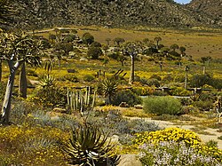
A springbok, one of Southern Africa's most well-known antelopes or gazelles
Sunset in the Great Karoo, near Sutherland, showing a multibladed windpump, which has made permanent settlement and farming possible in this thirsty land. These windpumps are as iconic of the Great Karoo as are the flat-topped Karoo Koppies.
The Lord Milner Hotel in Matjiesfontein, in the Lower Karoo, next to the Matjiesfontein railway station, on the railway line from Cape Town to Johannesburg
A blockhouse in the eastern Karoo