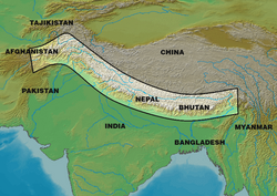
アジア大陸の南部に位置し、インド亜大陸の平原と広大なチベット高原を隔てるヒマラヤ山脈は、地球上で最も高く、険しい山岳地帯として知られています。世界最高峰のエベレストをはじめ、標高7,200メートルを超える峰が100以上も点在するこの地域は、単なる地理的な境界ではなく、地球のダイナミックな活動を象徴する場所です。
Key Facts
- 最高地点: エベレスト(標高 8,848.86m)
- 総延長: 約2,400kmの弧状に展開
- 形成要因: インドプレートとユーラシアプレートの衝突
- 地質学的特徴: 現在も年間約5mmの速度で隆起し続けている
- 水資源: 約15,000の氷河を抱え、「第三極」とも呼ばれる
- 主要国: ブータン、中国、インド、ネパール、パキスタン
地球を揺るがす巨大な衝突:ヒマラヤの成り立ち
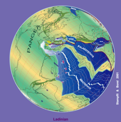
ヒマラヤ山脈の形成は、数千万年にわたる壮大なプレートの移動によってもたらされました。かつてゴンドワナ大陸から分離したキメリアと呼ばれる地塊がユーラシア方向へ漂い、古テチス海を閉鎖させ、同時に新テチス海を開いたことが始まりです。
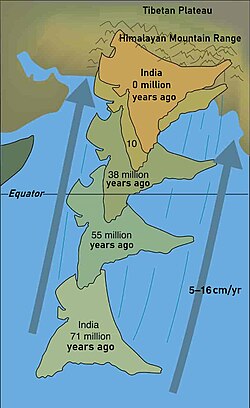
その後、約7,100万年前からインドプレートが年平均5〜15センチメートルの速度で北上し、ユーラシアプレートへと衝突しました。この衝突により、インドプレートの上層が折り畳まれる「ナップ形成」が起こり、地殻が押し上げられて巨大な山脈が誕生しました。一方で、より深い地殻やマントルはユーラシアプレートの下へと沈み込んでいきました。
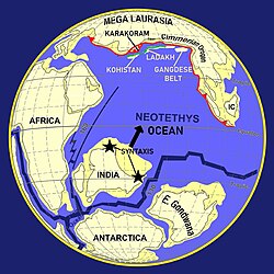
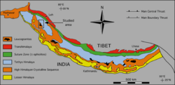
最終的な衝突に至る前には、カラコルムやコヒスタン・ラダック島弧、ガングデセ帯などがユーラシア側に付加されていました。これらの複雑な地質学的プロセスが、現在の多様な岩相(変成岩や堆積岩)を生み出しています。
現在もインドプレートは年約67mmの速度で北上し続けており、その圧力によってチベット高原は押し上げられ、ヒマラヤ山脈は年間約5mmのペースで成長しています。この絶え間ない地殻変動が、この地域を地震の多発地帯にしています。
地理的構造と主要な特徴
山脈は西のナンガ・パルバットから東のナムチャ・バルワまで、約2,400kmにわたって弧を描いています。幅は西端の350kmから東端の151kmまで変化しています。特に、ヒマラヤ山脈とチベット高原を分かつインダス・ヤルンツァンポ縫合帯は、地質学的に極めて重要な境界線となっています。
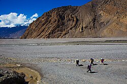
山脈の中央部には、ネパールのダウラギリやアンナプルナといった8,000メートル級の峰がそびえ立ち、それらを分かつカリ・ガンダキ峡谷は、生態学的・地形的に東ヒマラヤと西ヒマラヤを分ける重要な分水嶺となっています。
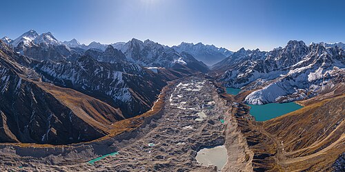
さらに東へ進むと、世界最高峰のエベレストを含むマハラングル・ヒマール地域に到達します。ここにはチョ・オユー、ローツェ、マカルーといった世界トップクラスの高峰が集中しており、トレッキングで人気のクンブ地域もこのエリアに含まれます。
「第三極」としての水資源と環境
ヒマラヤ山脈は、南極と北極に次ぐ世界第3の氷雪蓄積量を誇るため、「第三極」と呼ばれています。約15,000もの氷河が存在し、合計で約12,000立方キロメートルの淡水を蓄えています。これらはガンジス川やインダス川などの大河の源流となり、数億人の生活を支えています。
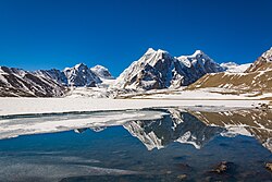
特筆すべきは、北回帰線に近い低緯度にありながら、標高が高いために万年雪が存在することです。永久雪線は通常5,500メートル付近にあり、これは赤道付近の山々に比べて約900メートルも高い数値です。
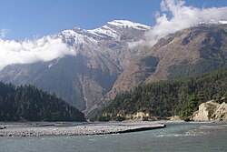
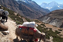
この過酷な環境の中にも、レッドパンダやヒマラヤタール、タキンといった固有の野生動物や、多様な高山植物が適応して生存しています。また、ヤクなどの家畜と共に暮らす人々が、この険しい地形の中で独自の文化を築いています。
ヒマラヤ山脈の概要まとめ
| 項目 | 詳細内容 |
|---|---|
| 最高峰 | エベレスト (8,848.86 m) |
| 全長 / 幅 | 約 2,400 km / 151 〜 350 km |
| 主な岩石 | 変成岩、堆積岩 |
| 氷河数 | 約 15,000 個 |
| 隆起速度 | 約 5 mm / 年 |
| 主要河川 | インダス川、ガンジス川、ヤルンツァンポ・ブラマプトラ川 |
Frequently Asked Questions
ヒマラヤ山脈は今でも高くなっていますか?
はい。インドプレートがユーラシアプレートに押し込まれ続けているため、地質学的に非常に活発であり、年間約5mmの速度で隆起し続けています。
なぜ「第三極」と呼ばれているのですか?
南極と北極に次いで、世界で3番目に多くの氷と雪(淡水)を蓄えている地域であるため、比喩的にそう呼ばれています。
エベレスト以外に高い山はありますか?
はい。標高8,000メートルを超える「8,000メートル峰」が複数存在します。例えば、K2(カラコルム山脈)や、カンチェンジュンガ、ローツェ、マカルーなどが挙げられます。
ヒマラヤ山脈の形成にどれくらいの時間がかかりましたか?
プレートの移動は約7,100万年前から始まっており、数千万年という膨大な時間をかけて現在の巨大な山脈が形成されました。
雪線が他の地域の山より高いのはなぜですか?
ヒマラヤ山脈が北回帰線に近い低緯度に位置しているため、赤道直下の山々に比べて気温が高くなりやすく、結果として雪が積もる境界線(雪線)が高くなっています。
References
- Sovereignty over the range is contested in several places, most notably in the .
- They are also known as "the Himalaya Mountains". In western literature, some writers refer to it as the Himalaya not changed in English. Other names: سلسلہ کوہ ہمالیہ in , হিমালয় পর্বতমালা Himaloẏ Porbōtmala in , : 喜马拉雅山脉; : 喜馬拉雅山脉; : Xǐmǎlāyǎ Shānmài in .
- ; pronounced in Sanskrit: ; from himá 'snow, frost' and ā-laya 'dwelling, abode'),
- as seen from a plane approximately above the historic village, in , Pakistan
- Terrane: "A far traveled crustal block accreted to a continent. Due to its remote origin, the terrane shows a different geological evolution compared to adjacent parts of the continent."
📸 フォトギャラリー