An azimuthal projection showing the Arctic Ocean and the North Pole. The map also shows the 75th parallel north and 60th parallel north.
← ホームへ戻る

北極点地球の頂点における地理的特性と探検の歴史

🗓 2026年8月11日

地球の自転軸が北半球の表面と交わる一点、それが北極点地理的北極点)です。磁北点とは異なる「真北」を定義するこの地点は、地球上で最も北に位置する場所であり、南極点と正反対の対蹠点にあります。

北極点に立つと、あらゆる方向が「南」となり、すべての経線が一点に集約されます。そのため、特定の経度は定義されず、また特定のタイムゾーンも割り当てられていないため、利用者が任意の時間を現地時間として採用することができます。
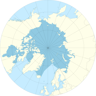
An azimuthal projection showing the Arctic Ocean and the North Pole. The map also shows the 75th parallel north and 60th parallel north.

Key Facts

  • 地理的定義:北緯90度に位置し、地球の自転軸の北端である。
  • 地表の状態:陸地はなく、北極海を覆う流動的な海氷の上に位置する。
  • 水深:1958年の測定では4,087m、2007年の調査では4,261mと記録されている。
  • 最寄りの陸地:グリーンランド北岸のカフェクルッベン島(約700km)が一般的とされる。
  • 最寄りの居住地:カナダのエルズミア島にあるアラート(約817km)。

北極点の物理的環境と地理

南極点が大陸という強固な陸地の上にあるのに対し、北極点は北極海の中央に位置しています。ここはほぼ一年中、絶えず移動し続ける海氷に覆われており、恒久的な観測基地の建設は不可能です。
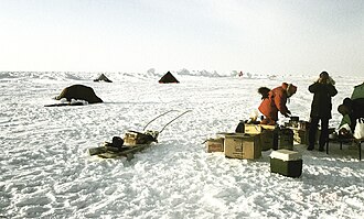
Temporary research station of German-Swiss expedition on the sea ice at the Geographic North Pole. Drillings at the landing site at 90°N showed an average ice thickness of 2.5 m (8 ft 2 in) on April 16, 1990

海氷の表面には、氷盤同士が衝突して形成される圧力リッジ(氷の盛り上がり)と呼ばれる地形が見られます。これらは時に1km以上の長さに達することもあります。
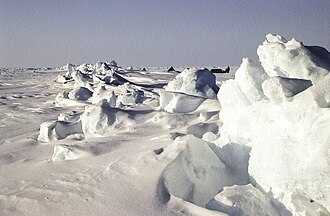
This pressure ridge at the North Pole is about 1 km (1⁄2 mi) long, formed between two ice floes of multi-year ice.

近年の気候変動に伴い、北極の海氷は減少傾向にあります。一部の研究では、21世紀後半まで、あるいはそれ以前に、季節的に氷が消失する時期が来ると予測されています。
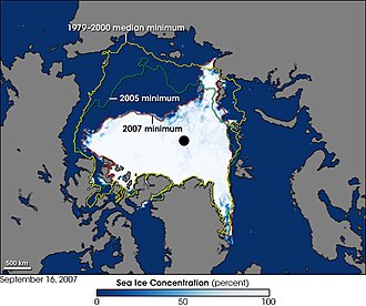
Arctic ice shrinkages of 2007 compared to 2005 and also compared to the 1979–2000 average.

北極点の気候と日照

北極点では極端な日照サイクルが繰り返されます。太陽が地平線上に現れる時期と、完全に沈む時期があり、その合間には数週間にわたる「薄明(トワイライト)」の期間が存在します。
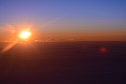
The sun over the horizon as seen from the North Pole looking towards the 180th meridian (the International Date Line), 2015

生態系と野生動物

餌の不足から、ホッキョクグマが北緯82度以北へ進出することは稀ですが、北極点付近で目撃された記録もあります。また、ワモンアザラシや、北緯89度40分付近で観察されたホッキョクギツネなど、限られた野生動物がこの過酷な環境に適応しています。

北極点到達への挑戦と探検史

人類にとって北極点への到達は長年の憧れであり、多くの地図製作者や探検家がその姿を追い求めました。初期の地図では想像に基づいた描写が多く見られましたが、次第に科学的なアプローチへと移行しました。
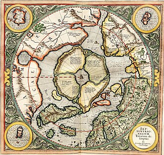
Gerardus Mercator's map of the North Pole from 1595
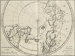
C.G. Zorgdragers map of the North Pole from 1720

地上と海上のアプローチ

1900年代初頭、ロバート・ピアリーらが北極点到達を主張し、当時のメディアで大きく報じられました。しかし、現代の歴史家の間ではその真偽について激しい論争が続いています。

Peary's sledge party at what they claimed was the North Pole, 1909. From left: Ooqueah, Ootah, Henson, Egingwah, and Seeglo.[8]
Although heavily disputed by modern historians, Peary & his team were given credit for the discovery of the North Pole by the contemporary press.

その後、探検の手法は多様化しました。フリチョフ・ナンセンによる船を用いた挑戦や、1949年にソ連の科学者がパラシュートで北極点に降り立った事例などが挙げられます。
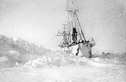
Nansen's ship Fram in the Arctic ice

潜水艦による到達と深海調査

1958年、アメリカ海軍の原子力潜水艦USSノーチラスが世界で初めて北極点の下を通過しました。その後、USSスケートが氷を突き破って浮上し、海上の船舶として初の到達を果たしました。
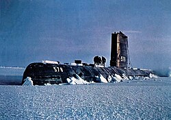
USS Skate at drift station Alpha, 1958

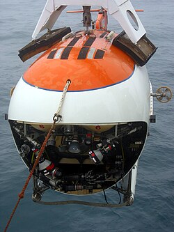
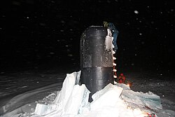
1977年にはソ連の砕氷船アルクティカが表面から到達し、2005年にはUSSシャーロットが厚さ155cmの氷を突破して浮上しています。さらに2007年には、ロシアの潜水艇「ミル」が北極点直下の海底まで到達し、水深を精密に測定しました。
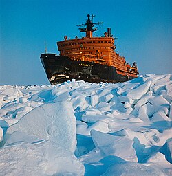
Soviet icebreaker Arktika, the first surface ship to reach the North Pole, 1977
USS Charlotte at the North Pole in 2005
Russian MIR submersible, one of the two vehicles that were used in the first ever manned descent to the seabed under the North Pole

現代の遠征と研究

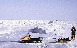
現代では、ドイツの大学による研究遠征や、ロシアによる民間基地「バルネオ」の運営など、科学的な調査が主目的となっています。スノーモービルなどの近代的な輸送手段が活用され、氷厚の測定や気候変動の研究が行われています。
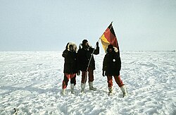
Participants of the first German North Pole expedition 1990 from University of Giessen
The German North Pole expedition 1990, Ski-Doo for local research on pack-ice
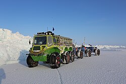
Yemelya, an all terrain Russian amphibious vehicle

北極点近辺の気象データ(参考)

北極点から約709km離れたグリーンランドの気象観測所における11年間の平均データは以下の通りです。北極点自体の気候を推測する重要な指標となります。

北極圏観測所(北緯83°38′)の平均気温データ
最高気温 (℃) 平均気温 (℃) 最低気温 (℃)
1月 -29 -31 -33
4月 -22 -23 -26
7月 2 1 0
10月 -8 -10 -11
年平均 -15 -16 -18

Frequently Asked Questions

北極点に住んでいる人はいますか?

いいえ、北極点は流動的な海氷の上にあり陸地がないため、恒久的な居住地や基地を建設することはできません。一時的な漂流観測所や季節的なキャンプが設置されるのみです。

北極点での時間はどう決めていますか?

北極点には割り当てられたタイムゾーンが存在しません。そのため、遠征隊や研究者は自分たちが便宜的に決めた時間や、出発地の時間などを現地時間として利用しています。

北極点からどの方向に行けば南になりますか?

北極点は地球の最北端であるため、そこからどの方向に進んでも必ず「南」に向かうことになります。

北極点と磁北点は同じ場所ですか?

いいえ、異なります。北極点(地理的北極点)は地球の自転軸に基づく固定された地点ですが、磁北点は地球の磁場によって変動するため、時間とともに位置が変化します。

北極点にホッキョクグマは住んでいますか?

基本的には北緯82度付近までが主な活動範囲ですが、稀に北極点付近まで移動してくる個体が目撃されており、生存可能な環境ではあります。

References

  1. Data is from a Greenlandic weather station at 83°38′N 033°22′W / 83.633°N 33.367°W / 83.633; -33.367 (Greenlandic Weather Station) located 709 km (441 mi) from the North Pole

📸 フォトギャラリー

An azimuthal projection showing the Arctic Ocean and the North Pole. The map also shows the 75th parallel north and 60th parallel north.
Temporary research station of German-Swiss expedition on the sea ice at the Geographic North Pole. Drillings at the landing site at 90°N showed an average ice thickness of 2.5 m (8 ft 2 in) on April 16, 1990
This pressure ridge at the North Pole is about 1 km (1⁄2 mi) long, formed between two ice floes of multi-year ice.
Gerardus Mercator's map of the North Pole from 1595
C.G. Zorgdragers map of the North Pole from 1720
Nansen's ship Fram in the Arctic ice
Peary's sledge party at what they claimed was the North Pole, 1909. From left: Ooqueah, Ootah, Henson, Egingwah, and Seeglo.[8]
Although heavily disputed by modern historians, Peary & his team were given credit for the discovery of the North Pole by the contemporary press.
USS Skate at drift station Alpha, 1958
Soviet icebreaker Arktika, the first surface ship to reach the North Pole, 1977
Participants of the first German North Pole expedition 1990 from University of Giessen
The German North Pole expedition 1990, Ski-Doo for local research on pack-ice
USS Charlotte at the North Pole in 2005
Russian MIR submersible, one of the two vehicles that were used in the first ever manned descent to the seabed under the North Pole
Yemelya, an all terrain Russian amphibious vehicle
Arctic ice shrinkages of 2007 compared to 2005 and also compared to the 1979–2000 average.
The sun over the horizon as seen from the North Pole looking towards the 180th meridian (the International Date Line), 2015