地球の表面の約70.8%を覆う海洋は、単なる水の集まりではなく、地球全体の気候や生命維持を司る巨大なシステムです。総面積は約3億6,100万平方キロメートルに及び、地球上の水の97.5%がここに集中しています。この広大な水圏は、深海から海面まで多様な環境を持ち、複雑な物理的・化学的相互作用を通じて地球の環境を安定させています。
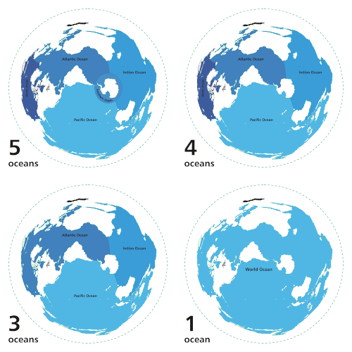
主要な海洋の区分と地理的特徴
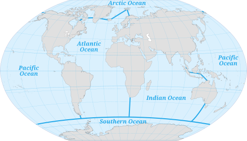
世界海洋は、地理的な境界に基づいて主に5つの海域に分けられます。最大規模の太平洋が全体の約半分を占め、次いで大西洋、インド洋、南極海、そして最小の北極海と続きます。これらの海域は互いに連結しており、一つの巨大な水塊として機能しています。
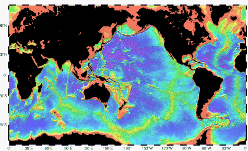
海洋の底は平坦ではなく、ダイナミックな地形が広がっています。大陸棚や海洋高原といった比較的浅い場所から、数千メートルの深さに達する深海平原、そして地球上で最も深い地点であるチャレンジャー海淵(水深10,935m)を含む海溝まで、多様な起伏が存在します。
また、陸地から最も離れた地点として「ポイント・ネモ」が知られており、最寄りの陸地まで約2,688kmもの距離があるため、宇宙船の墓場としても利用されています。
海洋の物理的特性とダイナミクス
温度と塩分濃度の変動
海水の温度は、太陽放射の影響を強く受けます。熱帯地方の海面では30°Cを超えることもありますが、極圏では海氷が形成される約-2°Cまで低下します。一方で、深海では水温が-2°Cから5°Cの範囲で安定しています。
塩分濃度は、蒸発量と降水量のバランスによって地域ごとに異なります。一般的に、蒸発が激しい熱帯域では塩分濃度が高くなり(35‰〜37‰)、降水量が多い極域では低くなる(28‰〜32‰)傾向にあります。平均的な塩分濃度は約3.5%(35g/kg)です。
![Annual mean sea surface salinity in Practical Salinity Units (psu) from the World Ocean Atlas[121]](/images/b1/65/b165aac61b32934ef0a3c03c50190529dcbf08303e9cfcd74bdc46dd06f7fad4.png)
海洋循環と気候への影響
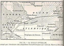
海水は、温度差や塩分濃度の違い(密度差)、風、そして地球の自転によるコリオリの力によって絶えず移動しています。これにより、メキシコ湾流や黒潮のような大規模な海流が形成されます。
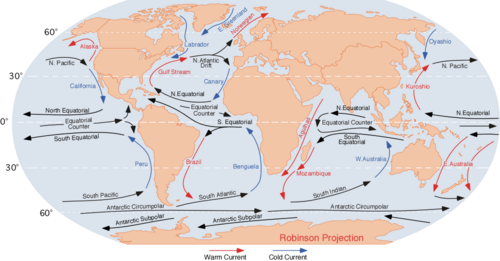
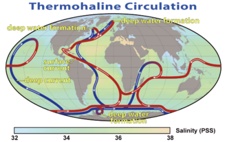
これらの海流は、赤道付近の熱を高緯度地域へ運ぶ「熱のコンベアベルト」として機能しており、特にヨーロッパなどの気候を温暖に保つ重要な役割を果たしています。また、表面の海流だけでなく、深層での熱塩循環も地球規模の気候調節に寄与しています。
潮汐と水循環
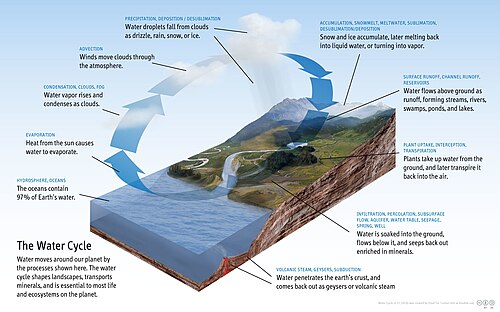
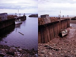
月や太陽の引力によって生じる潮汐は、沿岸域に周期的な水位変動をもたらします。また、海洋は地球の水循環の主役であり、蒸発を通じて大気に水分を供給し、雨として陸地に還元させるサイクルを駆動しています。
海洋の化学的組成と層構造
光の透過と深度による区分
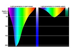
海洋は、太陽光が届く範囲によって「有光層」と「無光層」に分けられます。光の波長によって透過する深さが異なるため、深くなるにつれて色の見え方が変化します。
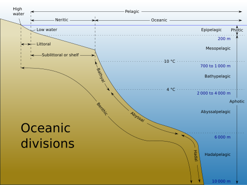
さらに、水深や温度、生物学的条件に基づいて、表層から深海まで複数のゾーンに区分されます。水深200m以上の領域は「深海」と呼ばれ、地球表面の約66%を占めています。
化学成分と炭素サイクル
海水には多くの元素が溶け込んでおり、塩素やナトリウムなどの主要成分は非常に長い滞留時間を持ちます。また、海洋は二酸化炭素の巨大な吸収源として機能しており、炭素サイクルを通じて地球温暖化の抑制に寄与しています。
![Diagram of the ocean carbon cycle showing the relative size of stocks (storage) and fluxes[132]](/images/38/45/3845a0c41ce9f17012e3f211caa920d677447403d518419d074429492f02cacf.jpg)
しかし、近年では大気中の二酸化炭素吸収量の増加に伴い、海水のpHが低下する「海洋酸性化」が進行しています。特に光合成が行われる表層(有光層)でのpH変化は、海洋生態系に深刻な影響を及ぼす可能性があります。
![Sea surface oxygen concentration in moles per cubic meter from the World Ocean Atlas[127]](/images/c9/f5/c9f56ebf6673c108bc3739df6e2296c511960438abaed557083f676c364d5021.png)
海洋生態系と生物多様性
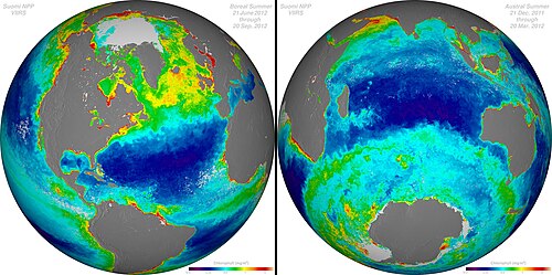
海洋生物は、光の届く表層から極限環境の深海まで幅広く分布しています。食物連鎖の基礎を支えるのは、光合成を行う植物プランクトンであり、その分布量はクロロフィル濃度によって測定されます。
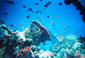
サンゴ礁のような生物多様性の高い複雑な生態系から、シャチのような頂点捕食者、そして目に見えない細菌類まで、多様な生命が共生しています。生物の多くは、水深に応じた特定の環境に適応して生息しています。
![Some representative ocean animals (not drawn to scale) within their approximate depth-defined ecological habitats. Marine microorganisms also exist on the surfaces and within the tissues and organs of the diverse life inhabiting the ocean, across all ocean habitats. The animals rooted to or living on the ocean floor are not pelagic but are benthic animals.[153]](/images/50/65/506512c7014e0c7b4041f7ddce151542965372f57c9982d1c8cfd0eb55f4974c.jpg)
![Killer whales (orcas) are highly visible marine apex predators that hunt many large species. However, most marine activity takes place among microscopic organisms that cannot be seen individually with the naked eye, such as marine bacteria and phytoplankton.[155]](/images/45/3c/453c5fda766de55cca4f1541124f8fd37dff8809ed7c121294f99bde0409a934.jpg)
人間活動による影響と保護
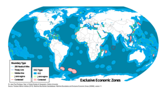
人類は排他的経済水域(EEZ)を通じて海洋資源を利用していますが、同時に深刻な負荷を与えています。過剰漁獲、プラスチックなどの海洋汚染、そして気候変動による海水温上昇や海面上昇が、海洋環境を脅かしています。
![Global cumulative human impact on the ocean[175]](/images/ae/79/ae795e89179826fd4669dceaa11609c8017f233430f4efadabad7e21f587d5cb.png)
Key Facts
- 表面積:地球全体の約70.8%を占める。
- 水量:地球上の全水量の97.5%が海洋に存在する。
- 最大水深:チャレンジャー海淵で約10,935mに達する。
- 平均塩分濃度:約3.5%(35‰)。
- 主要な役割:海流による熱輸送を通じて地球の気候を調節している。
- 環境課題:海洋酸性化やプラスチック汚染、過剰漁獲が深刻な問題となっている。
海洋データの概要まとめ
| 海洋名 | 面積比率 (%) | 体積比率 (%) | 平均水深 (m) |
|---|---|---|---|
| 太平洋 | 46.6% | 50.1% | 3,970 |
| 大西洋 | 23.5% | 23.3% | 3,646 |
| インド洋 | 19.5% | 19.8% | 3,741 |
| 南極海 | 6.1% | 5.4% | 3,270 |
| 北極海 | 4.3% | 1.4% | 1,205 |
Frequently Asked Questions
海洋の平均的な深さはどのくらいですか?
世界海洋の平均水深は約3,688メートルです。水深3,000メートルを超える海域が全体の約半分を占めており、非常に深い構造になっています。
海流はなぜ発生し、どのような役割がありますか?
海流は、風、水温や塩分濃度の違いによる密度の差、および地球の自転(コリオリの力)によって発生します。これらは熱やガス、栄養分を地球全体に運ぶことで、気候の安定化に寄与しています。
海洋酸性化とは何ですか?
大気中の二酸化炭素が海水に溶け込むことで、海水のpH値が低下し、酸性に傾く現象です。これにより、サンゴや貝類などの石灰化生物が殻を作りにくくなるなど、生態系への悪影響が懸念されています。
海氷ができると周囲の海水はどうなりますか?
海水が凍って海氷ができる際、塩分は氷に取り込まれにくいため、残された海水は塩分濃度が高くなります。塩分が高くなると密度が増し、水が深層へと沈み込むため、海洋の垂直循環を促進させます。
「ポイント・ネモ」とはどのような場所ですか?
南太平洋に位置し、あらゆる陸地から最も遠い「到達不能極」と呼ばれる地点です。最寄りの陸地まで約2,688km離れており、環境への影響を最小限にするため、役目を終えた人工衛星などを落下させる「宇宙船の墓場」として利用されています。
References
- Webb, Paul. "1.1 Overview of the Oceans". Roger Williams University Open Publishing – Driving learning and savings, simultaneously. Retrieved May 10, 2023.
- "How deep is the ocean?". NOAA's National Ocean Service. Retrieved May 10, 2023.
- Greenaway, Samuel F.; Sullivan, Kathryn D.; Umfress, S. Harper; Beittel, Alice B.; Wagner, Karl D. (2021). "Revised depth of the Challenger Deep from submersible transects; including a general method for precise, pressure-derived depths in the ocean". Deep Sea Research Part I: Oceanographic Research Papers. 178 103644. :2021DSRI..17803644G. :10.1016/j.dsr.2021.103644.
- "Coastline – The World Factbook". Central Intelligence Agency. Archived from the original on January 15, 2026.
- "Coastal and Marine Ecosystems – Marine Jurisdictions: Coastline length". . Archived from the original on April 19, 2012. Retrieved March 18, 2012.
- "How does the temperature of ocean water vary?: Ocean Exploration Facts: NOAA Office of Ocean Exploration and Research". Home. March 5, 2013. Retrieved May 10, 2023.
- "Voyager: How Long until Ocean Temperature Goes up a Few More Degrees?". Scripps Institution of Oceanography. March 18, 2014. Retrieved May 10, 2023.
- "8(o) Introduction to the Oceans". www.physicalgeography.net.
- "ocean, n". Oxford English Dictionary. Retrieved February 5, 2012.
- "ocean". Merriam-Webster. Retrieved February 6, 2012.
📸 フォトギャラリー