私たちの惑星は、目に見えない巨大な磁石に包まれています。この地球磁場は、単に方位磁石を機能させるだけでなく、太陽から降り注ぐ有害な粒子から生命圏を守る不可欠なシールドとして機能しています。地球の深部で生成されるこのダイナミックな磁気システムは、常に変動し続けており、時には北極と南極が入れ替わるという劇的な変化さえ起こします。
地球磁場を簡略化して捉えると、地球の中心に巨大な棒磁石が配置されているような状態です。ただし、この磁石は回転軸に対して約11度傾いており、地磁気の北極(北磁極)は物理的な意味での磁石の南極に相当します。これにより、磁石のN極を持つコンパスの針が北を指し示す仕組みになっています。
![Computer simulation of Earth's field in a period of normal polarity between reversals.[1] The lines represent magnetic field lines, blue when the field points towards the center and yellow when away. The dense clusters of lines are within Earth's core.[2]](/images/76/f0/76f043186fa71854ce30ffb7ee56138951a0dd70413bfcec3a45d88f84f3d197.gif)
Key Facts
- 磁場の強さ: 地表では約25,000〜65,000 nT(ナノテスラ)の範囲で変動します。
- 発生源: 地球の外核にある導電性流体の運動(ジオダイナモ)によって生成されています。
- 歴史: 最古の証拠では約37億年前から磁場が存在していたと考えられています。
- 極性の逆転: 数十万年から数千万年という不規則な間隔で、南北の磁極が入れ替わります。
- 北磁極の移動: 現在、北磁極はカナダからシベリア方向へ加速しながら移動しています。
磁場の構造と特性
磁束密度と強度
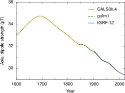
地球磁場の強さは「磁束密度」と呼ばれ、テスラ(T)またはガウス(G)という単位で測定されます。地表での強度は概ね22〜67 μTであり、これは強力な冷蔵庫用マグネット(約10,000 μT)に比べると非常に微弱です。また、この強度は一定ではなく、約2億年周期で変動しているという研究結果が報告されています。
磁極の定義と変動
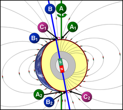
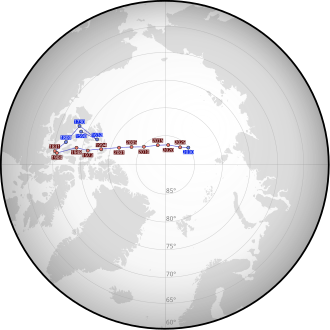
磁極の定義には、局所的な視点と地球全体の視点の2種類があります。局所的な定義では、磁場が完全に垂直になる地点を磁極と呼びます。北磁極では磁場が真下を向き、南磁極では真上を向きます。これらの磁極は固定されておらず、互いに独立して移動しており、北磁極の場合、年間最大40kmという速さで移動することが観測されています。
座標系と測定
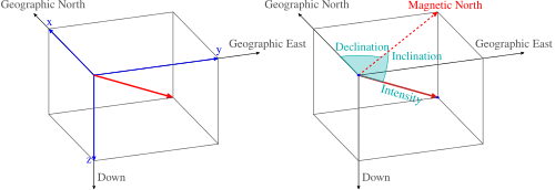
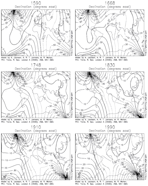
地磁気を正確に把握するためには、地理的な位置関係を示す座標系が重要になります。また、磁場の方向を示す「偏角」や、磁場が地表に対してどれだけ傾いているかを示す「伏角」などの指標を用いて、地球上のあらゆる地点での磁気特性が分析されています。
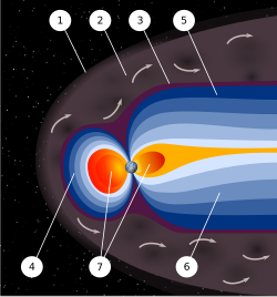
地球を包む磁気圏(マグネトスフィア)
地球磁場は地表付近に留まらず、宇宙空間まで広がって磁気圏を形成しています。これは太陽風(太陽から放出されるプラズマ流)が地球に衝突することで形成される構造で、弓状衝撃波(ボウショック)や磁気圏界面などの複雑な層で構成されています。この構造があるおかげで、地球の大気が太陽風によって剥ぎ取られるのを防いでいます。
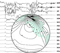
ただし、このシールドは完璧ではありません。太陽活動による磁気嵐が発生すると、地磁気に急激な変動が起こります。観測所では、こうした短期間の激しい変動が記録されており、宇宙天気予報などの重要なデータとして活用されています。
地磁気の時間的変化と逆転現象
地磁気逆転とエクスカーション
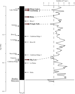
地球の歴史において、北極と南極の磁極が完全に入れ替わる「地磁気逆転」が繰り返し起こってきました。この証拠は海底の玄武岩や堆積物コアに残されており、直近の大きな逆転(ブルンズ・マツヤマ逆転)は約78万年前に発生しました。また、完全に逆転せず、一時的に軸が移動して元の位置に戻る「地磁気エクスカーション」という現象(例:約4万年前のラスシャンイベント)も存在します。

変動の速度
近年のシミュレーションによれば、磁場の方向変化の最大速度は年間約10度に達することがあり、これは現在の変化速度の約100倍、従来想定されていた速度の10倍に相当します。
磁場はどのようにして生まれるのか
ジオダイナモ理論
地球磁場の正体は、外核にある液体鉄などの導電性流体の運動です。コリオリの力によって流体がロール状に回転し、それが電気 currents を生み出し、さらに磁場を生成するというサイクル(ジオダイナモ)が形成されています。このプロセスにより、地球は巨大な電磁石のような状態を維持しています。
![A schematic illustrating the relationship between motion of conducting fluid, organized into rolls by the Coriolis force, and the magnetic field the motion generates.[53]](/images/b0/23/b0230cd960162feb915b11a4582e5d7b6e3a165c446feb2782484a167bda170e.webp)
詳細なモデルと異常
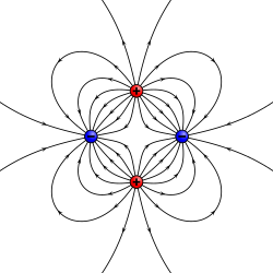
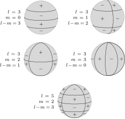
地球磁場は主に巨大な双極子(ダイポール)として近似されますが、実際にはより複雑な成分が含まれています。四重極(クアドラポール)などの高次成分や、地殻内の岩石による局所的な「磁気異常」が存在します。これらの詳細な構造を解析するために、球面調和関数を用いた数学的モデルが利用されています。
![A model of short-wavelength features of Earth's magnetic field, attributed to lithospheric anomalies[72]](/images/3d/cb/3dcb428087c193ee00543309677f37a0e0754fbac9fd6280cdc4b24834448c80.png)
外部要因の影響
内部のダイナモだけでなく、電離層(地球上層大気のプラズマ層)に誘導される電流も磁場に影響を与えます。これにより、太陽の位置に応じた日次変動が発生し、地表の磁場を最大1度ほど偏向させることがあります。
まとめ:地球磁場の概要
| 項目 | 詳細・数値 | 備考 |
|---|---|---|
| 地表磁場強度 | 25,000 〜 65,000 nT | 場所と時間により変動 |
| 主たる発生源 | 外核の導電性流体 | ジオダイナモ作用 |
| 磁極の性質 | 地理的北極 ≒ 磁気的な南極 | 逆向きの極性が配置 |
| 逆転の間隔 | 0.1百万年 〜 50百万年 | 不規則に発生 |
| 最古の存在時期 | 約37億年前 | グリーンランドの証拠より |
Frequently Asked Questions
磁極が逆転すると、私たちの生活にどのような影響がありますか?
地磁気逆転は数千年から数万年かけてゆっくりと起こるため、急激な破滅的影響はないと考えられています。ただし、磁場が弱まる期間があるため、宇宙放射線の流入が増え、通信インフラや電力網への影響が出る可能性が議論されています。
北磁極はなぜ常に移動しているのですか?
磁場を生成している地球外核の液体鉄の流れが常に変動しているためです。この流体のダイナミクスが変化することで、地表に現れる磁場の出口である磁極の位置も絶えず移動します。
磁気圏がない惑星はどうなりますか?
磁気圏がない、あるいは極めて弱い惑星(例:火星)では、太陽風が直接大気を叩くため、長い時間をかけて大気が宇宙空間へ剥ぎ取られてしまいます。地球の磁気圏は、大気と水を保持し、生命を維持するための重要な防壁となっています。
コンパスの針が指す「北」は、地理的な北極点と同じ場所ですか?
いいえ、異なります。地理的な北極点は地球の回転軸の端ですが、磁気的な北極(北磁極)はそこから離れた位置にあり、かつ常に移動しています。この差を「偏角」と呼びます。
References
- 1 2 Glatzmaier, Gary A.; Roberts, Paul H. (1995). "A three-dimensional self-consistent computer simulation of a geomagnetic field reversal". Nature. 377 (6546): 203–209. :1995Natur.377..203G. :10.1038/377203a0. 4265765.
- ↑ Glatzmaier, Gary. "The Geodynamo". University of California Santa Cruz. Retrieved 20 October 2013.
- ↑ Finlay, C. C.; Maus, S.; Beggan, C. D.; Bondar, T. N.; Chambodut, A.; Chernova, T. A.; Chulliat, A.; Golovkov, V. P.; Hamilton, B.; Hamoudi, M.; Holme, R.; Hulot, G.; Kuang, W.; Langlais, B.; Lesur, V.; Lowes, F. J.; Lühr, H.; Macmillan, S.; Mandea, M.; McLean, S.; Manoj, C.; Menvielle, M.; Michaelis, I.; Olsen, N.; Rauberg, J.; Rother, M.; Sabaka, T. J.; Tangborn, A.; Tøffner-Clausen, L.; Thébault, E.; Thomson, A. W. P.; Wardinski, I.; Wei, Z.; Zvereva, T. I. (December 2010). "International Geomagnetic Reference Field: the eleventh generation". Geophysical Journal International. 183 (3): 1216–1230. :2010GeoJI.183.1216F. :10.1111/j.1365-246X.2010.04804.x. :20.500.11850/27303.
- ↑ Shlermeler, Quirin (3 March 2005). "Solar wind hammers the ozone layer". News@nature. :10.1038/news050228-12.
- ↑ "Solar wind ripping chunks off Mars". Cosmos Online. 25 November 2008. Archived from the original on 4 March 2016. Retrieved 21 October 2013.
- ↑ Luhmann, J. G.; Johnson, R. E.; Zhang, M. H. G. (3 November 1992). "Evolutionary impact of sputtering of the Martian atmosphere by O + pickup ions". Geophysical Research Letters. 19 (21): 2151–2154. :1992GeoRL..19.2151L. :10.1029/92GL02485.
- ↑ Structure of the Earth Archived 2013-03-15 at the . Scign.jpl.nasa.gov. Retrieved on 2012-01-27.
- 1 2 3 4 McElhinny, Michael W.; McFadden, Phillip L. (2000). Paleomagnetism: Continents and Oceans. Academic Press. .
- ↑ Opdyke, Neil D.; Channell, James E. T. (1996). Magnetic Stratigraphy. Academic Press. .
- ↑ Mussett, Alan E.; Khan, M. Aftab (2000). Looking into the Earth: An introduction to Geological Geophysics. Cambridge University Press. .
📸 フォトギャラリー