Illustration of a Cartesian coordinate plane. Four points are marked and labeled with their coordinates: (2, 3) in green, (−3, 1) in red, (−1.5, −2.5) in blue, and the origin (0, 0) in purple.
← ホームへ戻る
直交座標系デカルト座標解析幾何学x軸y軸

直交座標系(デカルト座標系)の基礎から応用まで

🗓 2026年8月11日

数学や物理学において、空間上の位置を数値で正確に表現するための最も基本的な手法が直交座標系(デカルト座標系)です。このシステムは、互いに直角に交わる直線や平面を基準として、ある点までの距離を数値(座標)で示すことで、あらゆる点を一意に特定します。

17世紀にルネ・デカルトによって考案されたこの手法は、幾何学的な問題を代数方程式として処理することを可能にし、後の微積分学の発展に決定的な役割を果たしました。例えば、円や曲線といった図形を数式で記述でき、その面積や接線を計算することが可能になります。
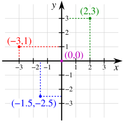
Illustration of a Cartesian coordinate plane. Four points are marked and labeled with their coordinates: (2, 3) in green, (−3, 1) in red, (−1.5, −2.5) in blue, and the origin (0, 0) in purple.

Key Facts

  • 定義: 互いに垂直な軸(座標軸)からの符号付き距離を用いて点を指定するシステム。
  • 原点: すべての軸が交差する点であり、座標は(0, 0)または(0, 0, 0)と表記される。
  • 次元の拡張: 2次元(平面)だけでなく、3次元(空間)やn次元のユークリッド空間まで拡張可能。
  • 数学的意義: 幾何学と代数学を融合させ、図形を方程式で表現することを可能にした。
  • 標準的な方向: 3次元では一般的に「右手系」という方向の規約が用いられる。

次元別の座標系の構造

1次元:数直線

最も単純な形式は、1本の直線上に座標を配置した「数直線」です。直線上のあらゆる点は一つの実数で表され、逆にすべての実数が直線上の特定の点に対応します。

2次元:デカルト平面

2本の垂直な軸(x軸とy軸)で構成される平面をデカルト平面と呼びます。x軸方向の値を横座標(abscissa)、y軸方向の値を縦座標(ordinate)と呼び、通常は(x, y)の形式で表記します。
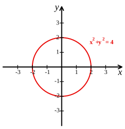
Cartesian coordinate system with a circle of radius 2 centered at the origin marked in red. The equation of a circle is (x − a)2 + (y − b)2 = r2 where a and b are the coordinates of the center (a, b) and r is the radius.

この平面では、軸によって領域が4つの「象限」に分割されます。第I象限(x+, y+)から始まり、反時計回りに第IV象限まで番号が振られます。

The four quadrants of a Cartesian coordinate system

3次元:空間座標

3次元空間では、互いに垂直な3つの平面からの距離を用いて点を指定します。x, y, zの3つの座標で構成され、軸のペアによって形成される座標平面が空間を8つの「八分限」に分割します。
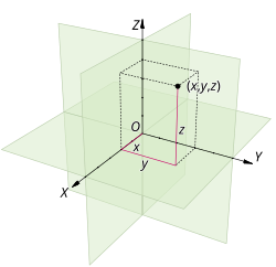
A three dimensional Cartesian coordinate system, with origin O and axis lines X, Y and Z, oriented as shown by the arrows. The tick marks on the axes are one length unit apart. The black dot shows the point with coordinates x = 2, y = 3, and z = 4, or (2, 3, 4).

3次元座標では、z軸を高さとして扱うことが多く、x軸からy軸への回転方向を定義する「右手系」という規約が標準的に採用されています。これにより、物理法則や数学的計算の整合性が保たれます。
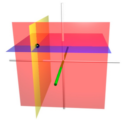
The coordinate surfaces of the Cartesian coordinates (x, y, z). The z-axis is vertical and the x-axis is highlighted in green. Thus, the red plane shows the points with x = 1, the blue plane shows the points with z = 1, and the yellow plane shows the points with y = −1. The three surfaces intersect at the point P (shown as a black sphere) with the Cartesian coordinates (1, −1, 1).

座標系の方向性と規約

右手系と左手系

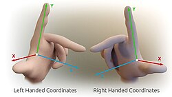
3次元空間の軸の向きには、右手系と左手系の2種類が存在します。右手系では、右手の親指をx軸、人差し指をy軸に向けると、中指がz軸の方向を指します。多くの科学分野ではこの右手系が標準です。
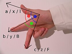
The right-hand rule

図面やディスプレイ上での表現において、視点によって凸状に見えるか凹状に見えるかで、右手系か左手系かの解釈が変わることがあります。

Fig. 7 – The left-handed orientation is shown on the left, and the right-handed on the right.

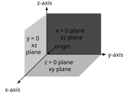
Fig. 8 – The right-handed Cartesian coordinate system indicating the coordinate planes

3D Cartesian coordinate handedness

分野による表記の違い

数学的な慣習ではy軸は上方向を正としますが、コンピュータグラフィックスや画像処理の分野では、画面上端を原点としてy軸が下方向に向かう座標系がしばしば利用されます。これは初期のディスプレイバッファのメモリ格納方式に由来しています。

幾何学的計算と変換

距離の算出

2点間の距離は、ピタゴラスの定理を応用して計算されます。2次元平面上の点(x1, y1)と(x2, y2)の距離dは、以下の式で求められます:d = √((x2 - x1)² + (y2 - y1)²)

アフィン変換と行列

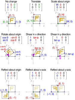
座標上の点を移動、回転、拡大縮小させる操作をアフィン変換と呼びます。これらは行列演算を用いて効率的に処理でき、特にコンピュータグラフィックスにおいて不可欠な技術です。

  • 平行移動: 各座標に一定の値を加算する。
  • 回転: 三角関数を用いて座標を変換する。
  • 拡大縮小(スケーリング): 座標に係数を乗じて大きさを変える。
  • せん断(シアリング): 一方の軸方向に沿って平行にずらす。

Effect of applying various 2D affine transformation matrices on a unit square (reflections are special cases of scaling)

座標系のまとめ

直交座標系の次元別特徴まとめ
次元 名称 座標の数 空間の分割 主な用途
1次元 数直線 1つ 2つの半直線 単純な数値の並び、時間軸
2次元 デカルト平面 2つ (x, y) 4つの象限 グラフ作成、2D設計、地図
3次元 空間座標 3つ (x, y, z) 8つの八分限 3DCG、物理シミュレーション、建築
n次元 ユークリッド空間 n個 超平面による分割 データ分析、機械学習、理論物理

Frequently Asked Questions

デカルト座標系と他の座標系の違いは何ですか?

デカルト座標系は直交する直線(または平面)からの距離で位置を指定しますが、極座標系では原点からの距離と角度で指定します。用途に応じて、円形の対称性がある場合は極座標系の方が計算が簡便になることがあります。

「右手系」とは具体的にどのようなルールですか?

x軸からy軸へ右手の指を回転させたとき、親指が指す方向をz軸の正の方向とする規約です。これにより、ベクトル外積などの計算結果が世界的に統一されます。

アフィン変換とは何のために行われますか?

図形を平行移動させたり、回転させたり、拡大・縮小させたりして、位置や形状を操作するために行われます。行列を用いることで、複雑な連続変換を一つの計算にまとめることができます。

なぜコンピュータグラフィックスではy軸が下向きなのですか?

歴史的に、コンピュータの画面描画においてメモリ上のデータ走査方向(左上から右下へ)に合わせて座標系を定義したためです。数学的な座標系とは異なりますが、実装上の効率が優先されています。

n次元座標系とはどのようなものを指しますか?

3次元を超えた多次元空間の概念です。例えば、100個の異なる変数を持つデータセットがある場合、それを100次元のユークリッド空間上の1点として表現し、点同士の距離を計算することでデータの類似性を分析できます。

References

  1. Consider the two or half-lines resulting from splitting the line at the origin. One of the half-lines can be assigned to positive numbers, and the other half-line to negative numbers.

📸 フォトギャラリー

Illustration of a Cartesian coordinate plane. Four points are marked and labeled with their coordinates: (2, 3) in green, (−3, 1) in red, (−1.5, −2.5) in blue, and the origin (0, 0) in purple.
Cartesian coordinate system with a circle of radius 2 centered at the origin marked in red. The equation of a circle is (x − a)2 + (y − b)2 = r2 where a and b are the coordinates of the center (a, b) and r is the radius.
A three dimensional Cartesian coordinate system, with origin O and axis lines X, Y and Z, oriented as shown by the arrows. The tick marks on the axes are one length unit apart. The black dot shows the point with coordinates x = 2, y = 3, and z = 4, or (2, 3, 4).
The coordinate surfaces of the Cartesian coordinates (x, y, z). The z-axis is vertical and the x-axis is highlighted in green. Thus, the red plane shows the points with x = 1, the blue plane shows the points with z = 1, and the yellow plane shows the points with y = −1. The three surfaces intersect at the point P (shown as a black sphere) with the Cartesian coordinates (1, −1, 1).
The four quadrants of a Cartesian coordinate system
Effect of applying various 2D affine transformation matrices on a unit square (reflections are special cases of scaling)
The right-hand rule
Fig. 7 – The left-handed orientation is shown on the left, and the right-handed on the right.
Fig. 8 – The right-handed Cartesian coordinate system indicating the coordinate planes
3D Cartesian coordinate handedness