Yowlumne territory at the time of the arrival of the Spanish
← ホームへ戻る

ベーカーズフィールドカリフォルニア州サンホアキン・バレーの歴史と文化の中心地

🗓 2026年8月15日

カリフォルニア州の肥沃なサンホアキン・バレーに位置するベーカーズフィールドは、豊かな歴史と多様な文化が交差する活気ある都市です。カーン郡の郡庁所在地であり、農業やエネルギー産業の拠点として発展してきたこの街は、現在では州内でも有数の人口を抱える主要都市へと成長しました。

主要な事実(Key Facts)

  • 人口: 約40万人(2020年国勢調査)、都市圏人口は約90万人に達する。
  • 地理: サンホアキン・バレーに位置し、標高は約123メートル。
  • 愛称: 「Bako」や、カントリーミュージックの聖地として「ナッシュビル・ウェスト」と呼ばれる。
  • 人口構成: ヒスパニック・ラティーノ系住民が人口の半数以上(52.7%)を占める多様なコミュニティ。
  • 経済: 公共サービス(カーン郡政府など)や教育機関が主要な雇用主となっている。

歴史の変遷:先住民から近代都市へ

この地域の歴史は、スペイン人が到来する以前から、先住民族であるヨウルムネ(Yowlumne)の人々が暮らしていたことに始まります。
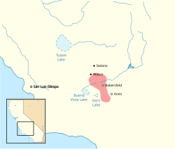
Yowlumne territory at the time of the arrival of the Spanish

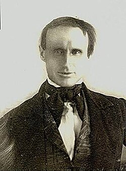
1776年にはスペインの司祭フランシスコ・ガルセスがこの地に到達し、ヨーロッパ文化との接触が始まりました。その後、1863年にトーマス・ベーカーがこの地域を訪れたことが、現在の都市名の由来となっています。
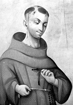
Spanish priest Francisco Garcés arrived in the Bakersfield area in 1776.
Bakersfield is named after Thomas Baker, who came to the area in 1863.

19世紀後半には鉄道の接続が確立され、商業的な発展が加速しました。1873年から1876年にかけて一度法人化され、その後1898年1月11日に再法人化を経て、近代的な都市としての基盤が整えられました。20世紀に入ると、1925年頃にはすでに都市としての景観が形成され始めていました。
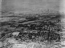
An aerial view of Bakersfield in 1925

都市の景観と建築的遺産

ベーカーズフィールドには、地域の歴史を物語る多様な建築様式が残っています。特にスペイン・コロニアル・リバイバル様式やスペイン・バロック・リバイバル様式の建物が特徴的です。

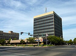
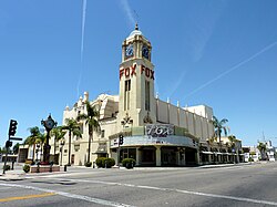
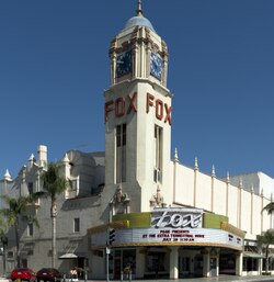
1930年に建設されたフォックス・シアターや、1931年築の第一バプテスト教会は、その建築美から国家歴史登録財(NRHP)に指定されています。また、ダウンタウンで最も高い建物であるトラクストン・タワー(バンク・オブ・アメリカ・ビルディング)は、近代的な都市の象徴となっています。
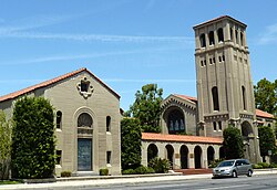
The First Baptist Church, built in 1931 in a Spanish Colonial Revival style is listed on the National Register of Historic Places.
The historic Spanish Baroque Revival style Fox Theater, built in 1930
Truxtun Tower, also referred to as the Bank of America Building, is the tallest in downtown and the second-tallest building in Bakersfield.
The Fox Theater

歴史的な保存地区としては、かつての商業中心地であったオールドタウン・カーンが挙げられます。ここはサマーナーという旧市街の周辺に位置し、かつてのサザンパシフィック鉄道駅などの遺構が残っています。
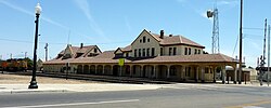
The old Southern Pacific Railroad station, currently the crew change depot for north and southbound Union Pacific Railroad trains. Old Town Kern is located primarily around Baker Street, near the former town of Sumner. It competed to be the commercial downtown, eventually losing to the present location west of Old Town.

地理・気候と人口統計

ベーカーズフィールドは、典型的な内陸性気候に属しています。夏は非常に暑く、7月や8月には最高気温が40度を超える日が多く見られます。一方で冬は穏やかですが、12月にはまとまった降水があるのが特徴です。

人口構成は時代とともに大きく変化しており、特にヒスパニック系住民の増加が顕著です。2010年の国勢調査に基づく人種分布マップからは、都市全体にわたる多様な居住形態が見て取れます。
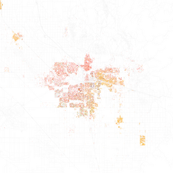
Map of racial distribution in Bakersfield, 2010 U.S. Census. Each dot is 25 people: ⬤ White ⬤ Black ⬤ Asian ⬤ Hispanic ⬤ Other

経済、教育、およびインフラ

地域の経済を支えているのは、行政サービスや教育、医療分野です。最大の雇用主はカーン郡政府であり、次いでカーン高校学区やBakersfield City School Districtなどの教育機関、そしてDignity Healthなどの医療機関が続いています。

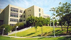
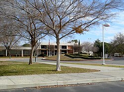
教育面では、カリフォルニア州立大学ベーカーズフィールド校(CSUB)やベーカーズフィールド・カレッジといった高等教育機関が充実しており、地域の知的拠点となっています。
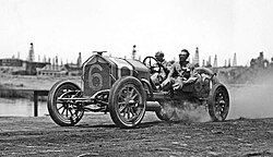
Harvey Herrick and his mechanician in Bakersfield during the 1911 Tevis Cup
CSUB's Walter Stiern Library
Bakersfield College

交通インフラとしては、州道178号線などの主要道路に加え、アムトラックの駅やメドウズ・フィールド空港が整備されており、広域的なアクセスを確保しています。
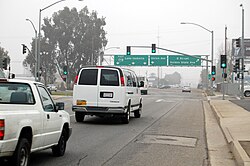
California State Route 178 at M Street near downtown Bakersfield on a foggy day
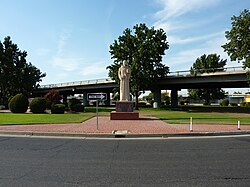
Garces Circle
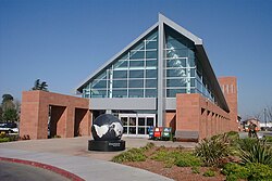
Amtrak station
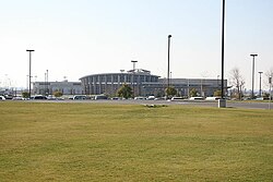
Meadows Field

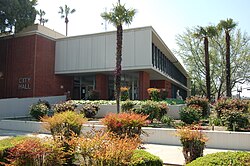
また、市役所は行政の中心として、市長室や市議会議場を擁しています。

City Hall is the seat of government for the city. Both the mayor's office and city council chambers are located inside.

文化・芸術とレクリエーション

音楽面では、カントリーミュージックの独自のスタイルである「ベーカーズフィールド・サウンド」で知られ、音楽文化が深く根付いています。また、スポーツ施設も充実しており、ディグニティ・ヘルス・アリーナではマイナーリーグのホッケー試合などが開催されています。
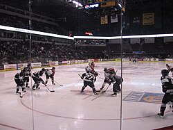
A minor league hockey game being played at Bakersfield's Dignity Health Arena

文化的なランドマークとしては、カーン郡博物館やベーカーズフィールド・カリフォルニアン新聞社ビル(NRHP登録)などが有名です。また、歴史的な図書館であるベーカー・ストリート分館も地域の文化遺産として大切にされています。
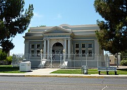
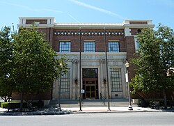
The Baker Street Branch Library, part of the Kern County Library system, is among the Bakersfield structures listed on the NRHP.
The Bakersfield Californian Building is also listed on the NRHP.

さらに、この街は国際的な交流にも積極的で、日本の和歌山県を含む世界各国の都市と姉妹都市提携を結んでいます。

最後に、地域の地理的状況を把握するためのカーン郡の地図を以下に示します。
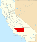
Kern County map

都市概要まとめ

ベーカーズフィールド基本データ
項目 詳細
正式名称 Bakersfield (ベーカーズフィールド)
州・郡 カリフォルニア州 / カーン郡
人口 (2020) 403,455人
主要産業 政府機関、教育、医療、農業
代表的な建築 フォックス・シアター、トラクストン・タワー
姉妹都市 (日本) 和歌山市

Frequently Asked Questions

ベーカーズフィールドという名前の由来は何ですか?

1863年にこの地域を訪れたトーマス・ベーカーという人物にちなんで名付けられました。

この街の音楽的な特徴は何ですか?

「ナッシュビル・ウェスト」という愛称を持つ通り、カントリーミュージックが盛んで、独自の「ベーカーズフィールド・サウンド」という音楽スタイルが発展しました。

どのような気候の地域ですか?

夏は非常に暑く、冬は比較的穏やかな気候です。特に夏季の最高気温は40度を超えることがあり、年間を通じて日照時間が非常に長いのが特徴です。

主要な雇用先はどこですか?

カーン郡政府が最大の雇用主であり、それに続いて地域の教育学区やDignity Health、Adventist Healthなどの医療機関が多くの雇用を創出しています。

歴史的に価値のある建物はありますか?

フォックス・シアターや第一バプテスト教会、ベーカー・ストリート分館図書館、ベーカーズフィールド・カリフォルニアン新聞社ビルなどが国家歴史登録財(NRHP)に指定されています。

References

  1. Mean maxima and minima (i.e., the highest and lowest temperature readings during an entire month or year) calculated based on data at the said location from 1991 to 2020.
  2. Official records for Bakersfield kept at Santa Fe Railway Station (at 14th and F Streets) from 1893 to September 1937, and since October 1937. For more information, see Threadex
  3. From 15% sample

📸 フォトギャラリー

Yowlumne territory at the time of the arrival of the Spanish
Spanish priest Francisco Garcés arrived in the Bakersfield area in 1776.
Bakersfield is named after Thomas Baker, who came to the area in 1863.
An aerial view of Bakersfield in 1925
The First Baptist Church, built in 1931 in a Spanish Colonial Revival style is listed on the National Register of Historic Places.
The historic Spanish Baroque Revival style Fox Theater, built in 1930
Truxtun Tower, also referred to as the Bank of America Building, is the tallest in downtown and the second-tallest building in Bakersfield.
Map of racial distribution in Bakersfield, 2010 U.S. Census. Each dot is 25 people: ⬤ White ⬤ Black ⬤ Asian ⬤ Hispanic ⬤ Other
The Fox Theater
A minor league hockey game being played at Bakersfield's Dignity Health Arena
Harvey Herrick and his mechanician in Bakersfield during the 1911 Tevis Cup
City Hall is the seat of government for the city. Both the mayor's office and city council chambers are located inside.
CSUB's Walter Stiern Library
Bakersfield College
The Baker Street Branch Library, part of the Kern County Library system, is among the Bakersfield structures listed on the NRHP.
The Bakersfield Californian Building is also listed on the NRHP.
California State Route 178 at M Street near downtown Bakersfield on a foggy day
Garces Circle
The old Southern Pacific Railroad station, currently the crew change depot for north and southbound Union Pacific Railroad trains. Old Town Kern is located primarily around Baker Street, near the former town of Sumner. It competed to be the commercial downtown, eventually losing to the present location west of Old Town.
Amtrak station
Meadows Field
Kern County map