西アジアに位置するアナトリア(小アジア)は、ヨーロッパとアジアを結ぶ戦略的な半島です。ギリシャ語で「日の出」を意味するその名の通り、東方の象徴として古くから多様な文化や民族が交差してきました。現在は主にトルコ共和国の領土となっており、国土の約97%を占めるこの地域は、険しい山脈から乾燥した高原、そして温暖な海岸線まで、極めて多様な自然環境を備えています。
主要な事実(Key Facts)
- 地理的定義: トルコの大部分を占める半島で、面積は約537,886平方キロメートルに及びます。
- 気候の多様性: 海岸沿いの地中海性気候から、内陸部の乾燥した高原地帯まで幅広く分布しています。
- 歴史的役割: ヒッタイト、ギリシャ、ローマ、ビザンツ、そしてトルコ系民族など、数多くの帝国が興亡した文明の十字路です。
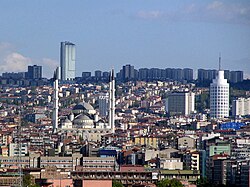
- 人口中心地: 最大の都市は首都アンカラであり、人口は約580万人を超えます。
地理的特性と自然環境
アナトリアの地形は、北部の黒海沿岸に走るポンティコス山脈と、南部の地中海沿岸の山々によって、中央の広大な高原地帯が囲まれているのが特徴です。この構造により、地域ごとに全く異なる気候帯が存在します。
内陸部の中央高原は非常に乾燥しており、厳しい気候条件にあります。一方で、南部の「トルコのリビエラ」と呼ばれる地域では、温暖な地中海性気候が広がり、観光地としても知られています。
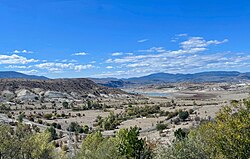
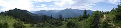
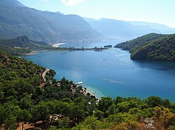
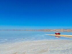
また、内陸には塩分濃度の高いトゥズ湖などの特徴的な水辺が存在し、地域の生態系に影響を与えています。
地質学的な視点では、約2万年前の最終氷期極大期には、アナトリアはヨーロッパ大陸と地続きでした。しかし、紀元前5,600年頃に氷床が融解して海面が約120メートル上昇したことで、トルコ海峡が形成され、マルマラ海や黒海が地中海とつながり、現在の半島形状となりました。
![Europe during the Last Glacial Maximum, c. 20,000 years ago. Anatolia was connected to the European mainland until c. 5,600 BCE,[8][9][10] when the melting ice sheets caused the sea level in the Mediterranean to rise around 120 m (390 ft),[9][10] triggering the formation of the Turkish Straits.[8][9][10] As a result, two former lakes (the Sea of Marmara and the Black Sea)[8] were connected to the Mediterranean Sea, which separated Anatolia from Europe.](/images/0c/3a/0c3a43a34ef3cca3945a6876e6c008ad62d9eae75dddd4f285cf2d7910af47d2.png)
歴史的変遷:先史時代から近代まで
古代文明の興隆
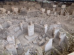
アナトリアは人類史上極めて重要な遺跡を擁しています。紀元前9,600年頃にまで遡るギョベクリ・テペの聖域は、定住以前の社会における組織的な建築活動を示しています。
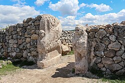
その後、ハッティ人やフルリ人が活動し、紀元前2千年紀には強力なヒッタイト帝国が台頭しました。彼らはルウィア人やパライ人とともにこの地を支配し、ハットゥシャなどの都市を築きました。
古典期と地中海世界の統合
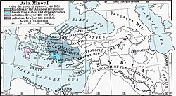
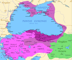
紀元前1千年紀以降、エーゲ海沿岸にはイオニア人やドーリア人などのギリシャ系植民都市が点在し、ギリシャ文化が浸透しました。その後、アレクサンドロス大王の征服を経てヘレニズム時代に入り、さらにローマ帝国の支配下へと移行します。ローマ時代には「東方教区」や「東方総督府」として、トラキアからエジプトまでを含む広大な行政単位の一部となりました。
![Roman Empire in 117 CE at its greatest extent, at the time of Trajan's death. vassal states[94]](/images/64/a6/64a61f1f1be24f93e400d64d252a530f86b5b0ad5d86ac92c87740545818d2e5.png)
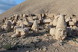
紀元前1世紀には、コムマゲネ王国がネムルト山に壮大な聖域を築くなど、独自の文化融合が見られました。
中世の激動とトルコ化の進展
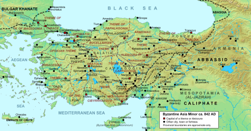
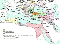
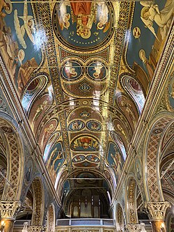
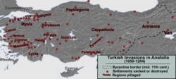
ビザンツ帝国(東ローマ帝国)時代、アナトリアは帝国の経済的・軍事的な基盤となりましたが、11世紀後半からセルジューク朝の侵攻を受けます。これにより、地域的な「トルコ化」が始まりました。その後、モンゴル帝国の影響を経て、14世紀にはオスマン帝国が台頭し、この地を拠点に世界帝国へと成長しました。
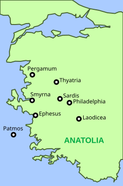
キリスト教の歴史においても重要であり、アジアの七つの教会などの拠点が存在しました。
近代における民族構成の変化
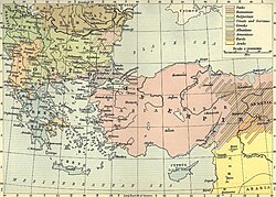
20世紀初頭まで、アナトリアは多民族・多宗教が共生する地域でした。しかし、第一次世界大戦前後、ナショナリズムの高まりとともに、アルメニア人、ギリシャ人、アッシリア人などのキリスト教徒に対する大規模な迫害や強制追放が行われました。1923年のギリシャ・トルコ間の人口交換を経て、古くからの先住コミュニティの多くが失われ、現在のトルコ共和国へと移行しました。
アナトリアの概要まとめ
| 項目 | 詳細内容 |
|---|---|
| 位置 | 西アジア(トルコ共和国の大部分) |
| 面積 | 約537,886 km² |
| 主要都市 | アンカラ(最大都市) |
| 主要言語 | トルコ語(主流)、クルド語、アラビア語、アルメニア語など |
| 主要地形 | 中央高原、ポンティコス山脈、地中海・エーゲ海沿岸 |
Frequently Asked Questions
「アナトリア」という名前の由来は何ですか?
ギリシャ語の「Anatolḗ(アナトレ)」に由来し、「日の出」や「東方」を意味しています。もともとはエーゲ海東岸の植民地や、より広い意味での東方地域を指していました。
地理的にアナトリアはどこまでを指しますか?
定義により異なりますが、一般的にはトルコ共和国のアジア側部分を指します。具体的には、イスケデルン湾から黒海に至る境界線で区切られる半島地域のことです。
この地域の気候にどのような特徴がありますか?
非常に多様です。沿岸部は温暖で雨の多い地中海性気候ですが、内陸の中央高原地帯は乾燥しており、夏は暑く冬は非常に寒い大陸性気候の傾向があります。
歴史的にどのような民族が住んでいましたか?
ヒッタイト、ルウィア、ギリシャ、ローマ、アルメニア、アッシリア、そしてトルコ系民族など、極めて多様な民族が時代ごとに支配権を握り、共生していました。
アナトリアが半島になったのはなぜですか?
氷河時代の終わり、氷床の融解によって海面が上昇したためです。紀元前5,600年頃に地中海の水位が上がり、陸地だった部分が海(トルコ海峡)となり、ヨーロッパから切り離されました。
References
- Additional alternative names include Asian/Asiatic Turkey, the Anatolian Peninsula, and the Anatolian Plateau.
📸 フォトギャラリー